Вы здесь
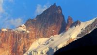
Glaciers of Karategin ridge.


Traveling in mountains of Pamir.
“I found out that there is no better way to find out if you like a person or are disgusted than to go on a trip with him”
Mark Twain.
The nature of Tajikistan.
South of the Zeravshan Range, parallel to the Sorbog River, the Karategin Range extends. It does not have a clear center line and is repeatedly cut by the deep valleys of the right tributaries of the Surkhob - Vakhsh river.
The northern slopes of this ridge are almost entirely covered by glaciers; on the southern slope of the ridge there are much less glaciers. In total, there are 166 glaciers on the Karategin ridge with a total area of 59.4 square kilometers.
The size of all glaciers is less than 3 square kilometers. 8 glaciers with a total area of 1.0 square kilometers are in the Kabudkrym mountains south of the Karategin ridge (Rototaev. 1979; Shchetinnikov. 1981. Catalog of glaciers. 1969 - 1982).
The total area of glaciation of the Karategin ridge is about 100 square kilometers.
The largest glaciers of the Karategin ridge.
The Obi-Kamarou glacier, with a length of 3.4 kilometers, an area of 1.9 square kilometers, located at an altitude of 3,000 to 4,020 meters above sea level, belongs to the Obiya-Kamarou River Basin, Nazar-Alyak.
The Fiturak Glacier, with a length of 3.3 kilometers, an area of 5.6 square kilometers, is located at an altitude of 3520 to 4320 meters above sea level, belongs to the Nazar-Alyak river basin.
The Ugolny Glacier, with a length of 2.5 kilometers, an area of 2.0 square kilometers, is located at an altitude of 3800 to 4100 meters above sea level, belongs to the Nazar-Ailyak River Basin.
The Shchikor Khan Glacier, with a length of 1.6 kilometers, an area of 0.5 square kilometers, located at an altitude of 3850 to 4350 meters above sea level, belongs to the Ob-Komarou River Basin.
Authority:
"Glaciers." L.D. Dolgushin, G.B. Osipova. Series "Nature of the world." Moscow, the publishing house "Thought". 1989.


