


![]()
Вы здесь
Pamir Highway.
Pamir Highway Tours in Tajikistan.
“The roads are tangled in the steppes of a foreign country.
I can’t afford the way: my legs are weakened.
Thanks at least for telling you
They come to this land, treating all the anxieties”
Babur.
Traveling on the roads of Tajikistan.
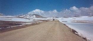
The famous alpine road with a length of more than 700 kilometers called the Pamir Highway begins in Khorog, runs along the border with Afghanistan and China, ending in the city of Osh in Kyrgyzstan. Several passes with a height of more than 4000 meters, rare gas stations, the almost complete absence of car services.
Perhaps this is the highest in some places asphalt road of such length in the world. Currently, this road is the only vital artery that connects the Pamirs to the outside world. Most of the road passes through the territory of Tajikistan, connecting the capital of the state of Dushanbe with the main city of Gorno-Badakhshan - Khorog by road.
Distinguish the Eastern Pamir Highway (Osh - Khorog) and the Western Pamir Highway (Khorog - Dushanbe). This road delivers goods of social (food, consumer goods, fuel, etc.) and industrial purposes. On the section from Osh to Khorog, the road passes through three main mountain passes: Taldyk 3,615 meters above sea level, Kyzyl-Art 4,280 meters above sea level and Akbaytal 4,655 meters above sea level, which is one of the highest mountain roads.
The Pamir is a storehouse of interweaving and geographical discoveries, “Ridge of the World”, as it is commonly called this mountainous region. The land here is worth its weight in gold, so the grown wheat is measured not with bags, but with skullcaps.
Alpine villages here are so isolated from each other that they speak different languages. If you start your way to the Pamir by car along the Pamir Highway (one of the most difficult roads in the world) from the fun and vibrant city of Osh, located in southern Kyrgyzstan, in the eastern direction of the Ferghana Valley, passing the low Chigirchik Pass and the Gulcha River Valley, travelers will find themselves on pass Taldyk 3650 meters above sea level, which leads to a long and tiring serpentine for drivers.
Descent from it leads to the village of Sarytash in the Alai Valley. Countless herds of sheep move this way to the Alai Valley in the spring, and back in the fall. Sarytash is a typical Kyrgyz highland village with houses of simple, unpretentious architecture.
If we continue from Sarytash along the Pamir Highway to the south, to the pass through the 3aalai ridge with the name Kyzylart, which means “red translated” from Kyrgyz, then, having climbed it, you will already be in the Pamirs, or in Mountain Badakhshan, whose workers are in Soviet times greeted all those who arrived at the pass with the inscription “The height of the pass is 4280 meters” cast in metal.
From the pass, the road goes down to the Markansu River Valley, which has eastward flow to China. In the summer, its channel in the upper reaches completely dries up. No vegetation. A caravan trail has been walking through the valley since ancient times.
In the Markansu Valley, remains of bonfires from sites dating from the 8th-9th centuries were discovered. They burned juniper and willow in bonfires, which indicates that these species were growing in the Markansu Valley at that time, therefore, the valley itself was much lower at that time.
Accordingly, it is possible to estimate the growth rate of height - about 5 - 7 cm per year. Were discovered here and tools of primitive man. If you look into the distant past, you can imagine the Pamirs as a wooded area with rivers and lakes, where many animals and birds were found - a real earthly paradise, which, perhaps, became the cradle of civilization.
Now the Markansu Valley is the most severe place on the plateau of the Eastern Pamirs. Even in the summer, the nights are always freezing. In the afternoon a strong wind rises; sudden dust and snow storms are possible.
According to eyewitnesses, in ancient times, piles of bones and mummified corpses of pack animals that remained from caravans that once passed lay along the ancient trail. Through the low watershed, the Pamir Highway goes to Lake Karakul, over which the Zaalaysky Ridge stands in the distance.
From the Karakul Lake, the Eastern Pamir Highway overlooks the expanses of the Eastern Pamir through the highest pass Ak-Baital 4655 meters above sea level. From the village of Murgab, the Pamir Highway goes through the expanses of the Eastern Pamirs with wide and flat valleys of the Murgab and Alichur rivers and goes through the Koytezek pass 4271 m high into the valley of the Gunt River, at the confluence of which the capital of Gorno-Badakhshan, the city of Khorog, is located.
The Osh-Khorog section with a length of 728 km was built in 1931 - 1934. Another way to the Pamirs is from Dushanbe, the capital of Tajikistan. The western part of the Pamir Highway, starting in Dushanbe, goes around the western end of the Peter Great ridge and leads south from the Obihingou River Valley through the Khaburab Pass 3270 meters above sea level to the Panj River Valley.
The border of Tajikistan with Afghanistan runs along it. The Western Pamir differs from the Eastern one in the sharp rugged relief with high ridges and glaciers. Stormy rivers flowing from glaciers have a predominant runoff from east to west to the Pyanj River, enveloping the Pamir from the south and west.
The Pamir Highway goes to Khorog along the Panj, from where there are branches to the Shahdara River basin, as well as further along the Pyanj River towards the Garm-Chashma resort and Ishkashim village in the South-Western Pamir.
Legends still tell about the construction in 1940 of the last section of the Pamir Highway connecting the city of Khorog with the city of Dushanbe (Stalinobad). The work was carried out in difficult conditions, among the high cliffs, some of its sections were previously impassable stone corridors with sheer walls, at the bottom of which rivers raged.
Construction was designed for 5 years. But as a result of the unprecedented enthusiasm of all the Tajik people, the 567 km long Pamir Highway named after Stalin was built in just 3 months. This highway, always considered very difficult, is now becoming extremely dangerous.
Blurred by mudflows, it begins to resemble old ravines. To drive along it, you need not only strong nerves, but also a lot of experience in emergency driving. Accidents on this road occur constantly. Nowadays, movement along it is extremely insignificant, but more recently, some 10 to 12 years ago, cars here moved in a continuous column.
Authorship:
Books: “Fan Mountains”, authors A.S. Mukhin, V.F. Gusev. "Nature of Tajikistan" publishing house "Thought", 1982. Pavel Luknitsky. “Traveling in the Pamirs”, Young Guard, 1955.