


![]()
Вы здесь
Nature of Hissar-Alai.
Tours in Pamir-Alai mountains.
“The traveler is usually extremely poorly aware of the country in which he is. He sees only the facade of the building. Almost everything inside is unknown to him.”
Voltaire.
Features of travel across Uzbekistan.
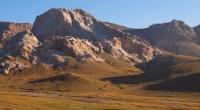
To the south of the Ferghana basin - and the eastern part of the Kyzylkum desert, there is a vast mountain region of the Pamir-Alai, consisting of three heterogeneous parts: the Gissar-Alai system, the South-Western Pamir-Alai and the Pamir Highlands.
The northern of these parts - the Hissar-Alai system - will now be considered as the Hissar-Alai mountain system, which belongs to the zone of Hercynian folding. The history of its geological development is similar to the geological history of the southern part of the Tien-Shan, and therefore geologists often attribute this system to the Tien-Shan, calling it the Southern Tien-Shan.
This point of view also penetrated into geographical literature, but in geography the idea presented by us about the division of the mountains of the east and southeast of Central Asia into mountain systems was more firmly established (Gvozdetsky, 1959).
The Gissar-Alai system extends, in the latitudinal direction, somewhat departs to the north in the western part. It stretches through the territory of Uzbekistan (in the west), Tajikistan (in the middle) and Kyrgyzstan (in the east).
The main northern ridges of the mountain system are the Turkestan and Alai ridges, bordering the Ferghana basin from the south. Both ridges are asymmetric in the transverse profile: their southern slopes are steep, the northern ones are elongated, accompanied by advanced spurs and ridges: the Kichik-Alai ridge, that is, the Small Alai, in the east and others.
From the line of the Alai and Turkestan ranges in the area of the Matchinsky mountain junction (the height of the Turkestan ridge here is up to 5621 meters at sea level), the Zeravshan ridge departs, which stretches west to the south of the Zerafshan river.
A little east of the junction with the Zeravshan ridge, the Alai ridge rises to 5539 meters at sea level, the height of the Zeravshan ridge in the middle part - 5489 meters at sea level - Chimtarg peak. Alay ¬, Turkestan and Zeravshan ranges are represented by numerous glaciers.
For them, as well as for the tallest advanced ridges (for example, Kichik-Alai), a typical alpine relief with mountain ice forms, jagged ridges, and sharp peaks is characteristic. An exception are the western parts of the Turkestan and Zeravshan ranges, medium-high and mostly flat-topped.
Here, due to the lower height, ancient alignment surfaces have been preserved. In the westernmost spurs of Gissaro-Alai, the Nuratau ridge and others, ancient alignment surfaces are also traced, the ridges raised due to tectonic movements and dissected by gorges, naturally younger than the aligned surfaces themselves.
From the high icy ridge of the Zeravshan ridge on the south side is the powerful Gissar ridge, also high and with glaciers on the ridge. The ridges of the Gissar-Alai system are composed of sedimentary and metamorphic Paleozoic rocks with the inclusion of large intrusive bodies of granites and diorites.
At the northern foothills of the Turkestan and Alai ridge ridges, Kichik-Alai and others, strongly dissected loess foothills, the “Adyrs,” are developed. The modern relief of the ridges is the result of the latest uplifts occurring in the Neogene and Quaternary.
Studies by N.A. Gvozdetsky, in the northern advanced ridges of the Alai ridge, the western part of Turkestan and in the extreme western spurs of the entire system showed that the concept of S. S. Schulz is applicable to the ridges of Gissar-Alai, as well as to the Tien-Shan (1948), that the formation of a mountainous relief is largely associated with tectonic deformations of an ancient leveled surface through the formation of wide and gentle folds - “folds of terrain of large radius”.
The movements along the longitudinal discontinuities are also undeniable. By a system of deep faults, the Hercynian structures of Gisaro-Alai are separated from the folded structures of the Pamir region of the Alpine folding region (Cenozoic folding of Tethys).
Earthquakes of the Surkhob valley are associated with these faults. The author of these lines got acquainted with the fresh traces of the catastrophic earthquake of 1949. During it, a deadly stony village that descended from the Darayhaus gorge was buried under the ancient Tajik city of Khait, which stood on a removal cone at the mouth of this gorge, and cliffs and ravines and weatherings buried the villages opening towards the Yasman valley.
In the Paleozoic limestones of Gissar-Alai, karst phenomena are developed, mainly caves, Kan-i-Gut cave with huge halls in the northern front ridge of the Turkestan ridge, caves in the front ridge of the Alai ridge and in the Osh mountains of the southeastern part of the Ferghana basin.
In the western part of the Zeravshan ridge, southwest of Urgut, on the Kirktau plateau, a typically pronounced karst landscape with funnels is observed, similar to the landscape of the Crimea. Here was discovered the fourth deepest in Central Asia, a depth of 950 meters karst abyss - Kiev.
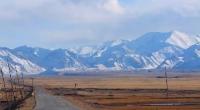
The climate of Gissaro-Alai is characterized by a change with height of thermal conditions, uneven distribution of precipitation and moisture. In the foothills and in the low mountains, winters are relatively short and mild, summers are long with high air temperatures.
The average July temperatures at the foot of the mountains are higher than 24 ° (Osh) and even 28 ° (Dushanbe). Precipitation falls more than in neighboring deserts (350 - 700 mm per year). At altitudes of 1500 - 3500 meters above sea level, the climate has characteristic mountain features, it is much cooler and much more moist.
Due to the peculiarities of atmospheric circulation, precipitation in the largest amount falls on the western, southwestern and southern slopes. Here, on the windward slopes, their annual number reaches 1000 - 2000 mm (however, evaporation is very large on the southern slopes, which often makes them relatively arid and devoid of dense vegetation), and on the sloped slopes it even drops in places in the middle mountains less than 200 mm per year.
The maximum precipitation at the foot of the mountains is spring, and higher is spring-summer. Rains in the mountains stop much later than on the neighboring plains, drought begins only in the second half of summer and does not last long, only August and September are sharply arid.
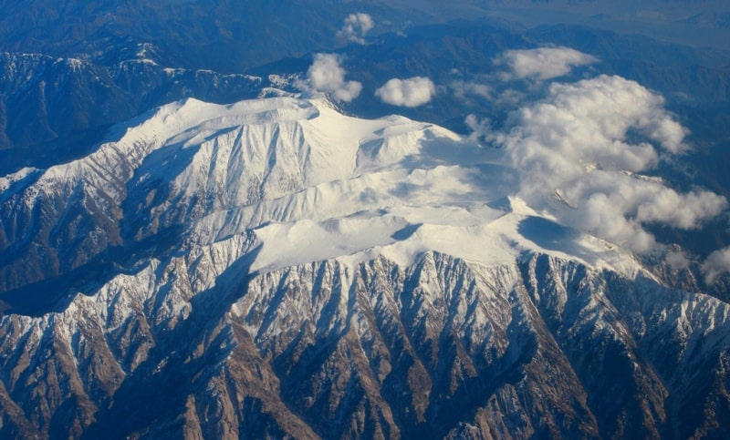
In the nival-glacial zone, the annual rainfall in the west reaches 2500 mm (Kotlyakov, 1977). The snow line on the Turkestan ridge has a height of about 3600 meters above sea level, in the east and south-east direction it rises to 4300 meters above sea level.
The area of glaciation is about 2300 square kilometers, the number of glaciers is 3859. The largest glacier - Zerafshansky - reaches 28 kilometers in length. The Gissaro-Alai rivers have mixed feeding with prevalence of glaciers and snow.
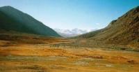
The share of glaciers is especially large near the headwaters of Zeravshan (Matcha River). Mountain lakes are famous for their picturesqueness, especially Iskanderkul Lake on the northern slope of the Hissar Range, which is related to the Zeravshan basin.
This wastewater dam lake, dammed by the final moraine of an ancient glacier. Picturesque Marguzor lakes, also in the basin of the Zeravshan river. In the mountains of the Gissar-Alai system, the high-altitude zonality of landscapes is clearly manifested.
Another important factor in landscape differentiation is the influence of slope exposure. The impact of the exposure is clearly visible on the example of the Turkestan ridge. On its northern slope (as well as on the northern slope of the Alai Range), beautiful juniper forests grow, the southern slope is extremely poor in vegetation.
The third factor in landscape differentiation is the intensification of the continental climate to the east, which modifies the spectrum of altitudinal zonality of landscape landscapes. In general, it is much like that in the south of the Western Tien-Shan.
The most significant difference is the absence of forests from the Tien Shan spruce; only juniper grows from conifers. The lower zone (500 - 900 - 1000 meters above sea level) is formed by subtropical semi-sheets of foothill plains and adyrs with ephemeral and wormwood and ephemeral vegetation on ordinary (typical) and dark gray soils.
Wormwood and ephemeral semi-deserts on dark gray soils and dark gray dry-steep soils are also common in the valleys of the internal part of the mountain system located at an altitude of 1000 - 1500 meters above sea level.
The next zone (900 - 1000 - 1800 meters above sea level) - subtropical steppes of loess foothills and middle riy. Large cereals and ephemeral vegetation dominate here on dark and gray dry steppe soils (upper gray soils). Within the zone, wheatgrass, motley, shrubby and steppe belts can be distinguished.
Among the shrubbery in the west, the exochordium dominates, and to the east - the wild rose. Under shrubbery thickets, dark and gray steppe soils are replaced by brown soils, which also pass into the next mid-mountain (1800 - 2600 - 2800 meters above sea level) zone - forest, meadow and steppe.
Its lower zone is characterized by meadow steppes, shrubbery (almonds below, exochordas in the west and wild rose to the east), broad-leaved forests of walnuts, maple, and others. Broad-leaved forests are mostly found on the Gissar Range, that is, in the southern part of the western half of the mountain system.
Only in the west walnut forests are widespread, maple penetrates into the middle part of Gissar-Alai. Above, in the upper zone of the forest, meadow and steppe zones, on the stony slopes, juniper dominates, which in the west also mixes with maple and echzochords. In the east, woods are mainly represented by junipers.
Mountain brown and brown soils are eroded under the juniper. The belt with juniper forests and woodlands occupies a large vertical space. The ridges of high ridges belong to the mountain and meadow zones (2500 - 2700 - 3500 - 3700 meters above sea level) with subalpine, alpine and subnival belts and to the nival and glacial zones crowning the spectrum.
In the foothills and advanced ridges of the Turkestan and Alai ridges, which form the southern border of the Fergana Basin, there is an important mining region. Polymetallic and mercury deposits are being developed here, sulfur, coal and lignite, and oil are mined.
Ores of tungsten, mercury, antimony, coal deposits are also in the Zeravshan basin. Limestones of advanced ridges and loesslike loam of foothills serve as raw materials for cement production. There are many other building materials.
The hydropower resources of Gissar-Alai are still used to a small extent. Dushanbe is supplied with energy by hydropower plants built on the Varzob River (Varzob and Nizhnevarzob Hydroelectric Power Plants), flowing from the southern slope of the Gissar Range.
Juniper forests are not subject to development because of their enormous soil protection and water conservation value. The pasture resources of the mountain meadows and steppes of the Gissar-Alai, as well as the ephemeroid vegetation of the Adyrs (spring pastures) are great and important.
On irrigated and non-irrigated land masses of foothills and low mountains, field cultivation is developed, there are many irrigated fields of cotton, orchards and vineyards abundantly bear fruit. Under the fruit nurseries and vineyards, new areas are being developed in the foothills of the Hissar ridge.
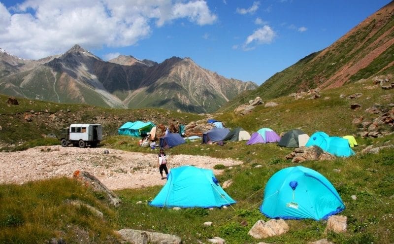
Many mountain ranges, for example, on the Turkestan ridge, in the Zaaminsu river basin, near Iskanderkul Lake, are excellent places for recreation and tourism.
Authority:
Series Nature is the world. "The mountains". N A. Gvozdetsky, Yu.N. Golubchikov. Moscow "Thought". 1987.
Photos by
Alexander Petrov.