


![]()
Вы здесь
Ridge of Chatkal.
Tourist travel in Kyrgyzstan.
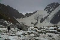
“Chatkal ridge in its highest part reaches an average height of 4200 - 4500 m, its individual peaks protrude strongly above the ridge line, the main peaks have a height of at least 5000 meters. The snow line lies above 4000 m, and due to the steepness of the slopes, even the highest peaks are almost snowless. Snow fields and glaciers lie on high plateaus, which are a characteristic feature of the ridge. The predominant rock on the crest is dense limestone, followed by limestone conglomerates. The shape of the peaks is unusually bizarre, which makes them very difficult and interesting objects for climbing. "The slopes of the ridge are dissected by a series of deep gorges, so narrow that glaciers that, undoubtedly, are located in their upper reaches are not visible."
E.S. Levin.
Travel on Chatkal ridge in Kyrgyzstan.
The Chatkal Range is located in the Western Tien-Shan, in Kyrgyzstan and Uzbekistan. The length of the ridge is about 200 kilometers, adjacent to the Talas Alatau. The height of the ridge is up to 4503 meters above sea level, the Atoynoksky ridge branches out to the southeast, with a length of over 60 kilometers and a height of up to 3897 meters above sea level and is a continuation of the Ferghana ridge.
Located in the southwestern part of Kyrgyzstan, the Chatkal Range is the highest in the Western Tien-Shan. In the northeastern part of the ridge, whose average height is about 4,000 meters above sea level, there are peaks reaching heights of 4,500 to 5,000 meters above sea level.
This highest part of the ridge is characterized by snow cover and the presence of glaciers, its length is about 100 kilometers. Chatkal foothills begin a few tens of kilometers east of Tashkent. In the region of the peak of 4062 meters above sea level, in the central part of the Chatkal ridge there is a complex mountain junction.
The Kuramin Range, with a length of about 170 kilometers and a height of up to 3,769 meters above sea level, goes south. The Sargardon spur, with a length of about 30 kilometers and a height of up to 3762 meters above sea level, leaves to the north-west.
The Kumbel spur, with a length of about 30 kilometers and a height of up to 3800 meters above sea level, leaves to the northeast. At the junction of the Kuramin ridge, the Angren Plateau is located, the average height of which is from 2500 to 3000 meters above sea level.
To the north of the Kyzylnur massif, up to 3267 meters above sea level, the Bolshoi Chimgan spur, up to 3309 meters above sea level, departs. The northern slopes descending into the Chatkal river valley are steep and short, with a vertical drop of 2,000 to 3,500 meters above sea level at a distance of 15 to 20 kilometers.
The southeastern slopes facing the Ferghana Valley are gentle and long, stretching up to 50 kilometers, are strongly dissected by tributaries of the Syr Darya River, with a vertical drop of 1000 to 3500 meters above sea level.
The total glaciation area of the Chatkal ridge is about 40 square kilometers. The height of the snow line on the northern slopes is from 3700 to 3800 meters above sea level, on the southern - about 4000 meters above sea level.
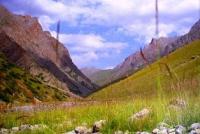
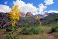
The Chatkal river valley is covered with mountain steppes, alternating with subalpine and alpine meadows, deciduous forests are found. On the southeastern slopes are wild fruit forests and walnut forests. Chatkal ridge serves as a watershed of two large river basins, its north-western slopes give rise to the Chatkal River, which is called Chirchik in its lower reaches, and its tributaries.
The southeastern slopes facing the Ferghana Valley feed mountain streams flowing into the Naryn and Syr Darya rivers. The rivers originating from the southeastern slopes, almost devoid of snow cover, are relatively shallow, in the summer they are almost completely dismantled for irrigation of collective farm fields.
The Chatkal Range has a decisive influence on the water regime of the Chirchik River, which feeds mainly on the waters of Chatkal. Extremely dry climate and the absence of rain in the summer months make mountain flows of glacial and snow origin the main source of water supply for the Tashkent region and a large hydropower and industrial center on the Chirchik River.
At the same time, the Chatkal mountains have a favorable effect on the climate of the north-eastern part of Fergana, delaying moist south-west winds and contributing to rainfall. In the southwestern part of Chatkal ridge, Chatkal reserve is located. In the north-eastern part, around the Sary-Chelek lake, there is the Sary-Chelek reserve, on the southern slope is the Orto-Tokoi reservoir in the Issyk-Kul region of Kyrgyzstan.
In the Chatkal ridge, in the upper reaches of the Chatkal valley, there is the settlement of Kulbes-Kan, X - XII centuries, on the southern slope near the village of Ala-Buka, the mausoleum of Shah-Fazil of the XII century). At the head of the Kara-Suu River, there are pillars of weathering Karo-Dzhigach.
Authority:
The book "Soviet Encyclopedia". Mountaineering regions of Kyrgyzstan, guidebook, author Vladimir Komissarov. G. Bishkek, 2010. http://vladsc.narod.ru/library/enc_tur/ch.htm#ch0