


![]()
Вы здесь
Glacier of Golubin in Ala-Archa gorge.
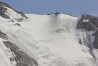
Photo tours and adventures in Ala-Archa canyon.
“Everything in excess is opposed to nature”
Hippocrates.
Guided Natural History Tours in Kurgyzstan.
Golubin Glacier is located in center of glaciation of northern slope of Kyrgyz Ala-Too in upper reaches of Ala-Archa gorge, belongs to Ala-Archa river basin, between glaciers: Tuyuk glacier in east and Manas glacier in Chui region in west.
Balance observations have been carried out since 1960 on the Golubin Glacier, which is 4.5 kilometers long and 6.2 square kilometers in area. It is a Hanging Valley Glacier with an average slope of 9 °. The highest point of the glacier is 4350 m. a. s. l., the firn basin is separated from the tongue by an icefall.
The tongue is clean, descends to 3250 m. a. s. l., the height of the food limit is 3870 meters above sea level. 1960-1982 on the tongue of the glacier, an average of 690 mm fell, and in the firn area - 840 mm of precipitation per year. For the same period, the average annual accumulation was 75.8 gram per square centimeter, ablation is 77.2 g / cm2, and the mass balance is 1.4 g / cm2 per year.
The total mass balance for 23 years was -31.7 g / cm2 (Aizin. 1985). A general retreat of a number of glaciers of the Kyrgyz ridge is observed. So, from 1917 to 1961, the Golubin glacier retreated by almost 1 kilometer, the Sovetkina glacier in the Alamedin river basin - by 360 meters.
The end of the Tushinsky glacier retreated 600 meters from 1906 to 1960, but by 1964 it had advanced 34 meters. In recent years, signs of an advance have been noted on other glaciers as well.
Geographic coordinates of Golubin glacier: N42°27'12 E74°29'48
Authority:
"Glaciers." L.D. Dolgushin, G.B. Osipova. Series "Nature of the world." Moscow, the publishing house "Thought". 1989.
Photos by:
Alexander Petrov.