


![]()
Вы здесь
Geography of Alai mountains.

Tours in the Alai Valley.
“...The view from the pass made us stop: a panorama of gigantic snow mountains opened before us. These mountains, however, were not all visible from the pass. The nearest ridges partially covered them. Meanwhile, I wanted to see as much as possible; before us was a place barely known by the name of Alai, and what lay behind it was unknown to anyone..."
A.P. Fedchenko.
Trip to Alai Valley.
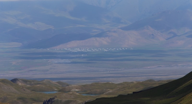
Alai valley was green with lush grass. June defeated the snow. The wild white desert turned into a ceremonial jailau - a rich, spacious pasture. An army of rams, yaks, horses, waiting for the snow to melt in the lower valleys of Kichik-Alai (“Small Alai”) entered here and broke the mountain silence.
We move ford Kizyl-su. Its name means “Red Water”, and the water in Kizyl-su is really red, because it is saturated with the red clays of the upper reaches of the Alai Dolima that are washed out by it. One and a half hundred kilometers from here, outside the Alai valley, where Tajiks live, they call the river in their own way - Surkhob, which is the same thing: "Red Water".
Even lower, in the middle of Tajikistan, this river, already coffee-brown, noisy and full of water, is called the Vakhsh River, famous for the construction of a powerful hydroelectric station and canal that irrigates tens of thousands of hectares of desert land - dozens of cotton-growing collective farms will appear on it.
Leaving mountains forever, spreading widely on the subtropical lowlands of southern Tajikistan, coming close to Afghanistan, Vakhsh merges into Panj, which in that place is called Amu-Darya. Only here, in the Alai valley, the Kizyl-su-Surkh-ob-Vakhsh river, you can still wade.
Immediately beyond the river, passing the tract Sarytash ("Yellow Stone"), where you can see the destroyed discount and several yurts set up by nomadic Kirghiz, we become a camp. * The station and the Vakhsh Canal named after Stalin, which irrigated about one hundred thousand hectares of land, went into operation in September 1933.
Alai Valley, or, as it is simply called, Alai, has an average height of 3 052 meters above sea level. The word "Alai" in the Jagatai-Turkish language, as defined by Professor A. A. Semenov, means a herd, flock, crowd, as well as a regiment, formation, detachment or battalion.
There are other explanations for this word. I have already said that they translate it with the word "paradise" - the pastures are so plentiful and juicy here. And they say that "al ah!" means “keep the month!”, that is, hurry up, the summer months are short in this highland valley!
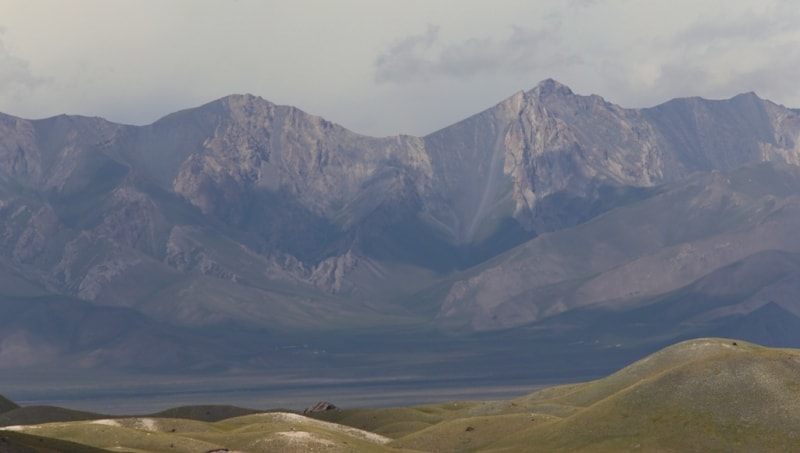
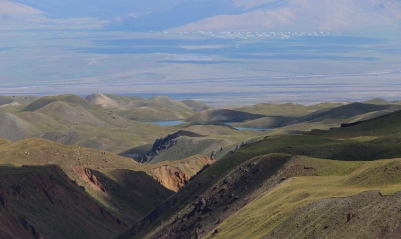
Alai is one of the most remarkable high mountain valleys of Central Asia. It is located approximately one hundred and fifty kilometers south of the Ferghana Valley, from which it is separated by a powerful Alai Range, which occupies all the space between the valleys with its branchy spurs.
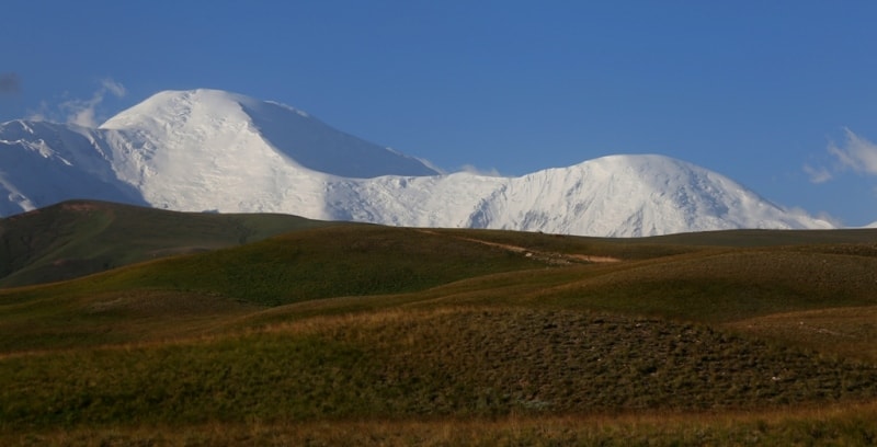
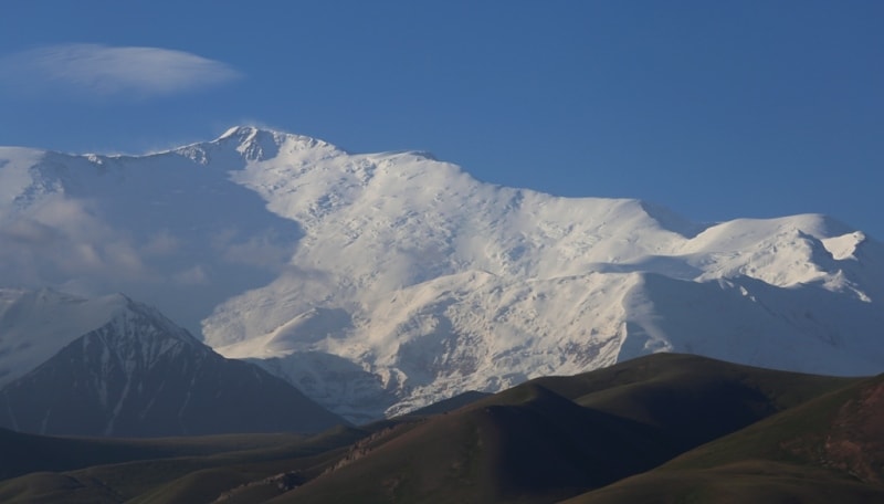
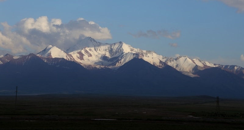
From the Alai Valley to the north, to the regional center of the Kyrgyz SSR of the city of Osh, about two hundred kilometers. The Alai Valley is a deep and wide depression, a tectonic depression sandwiched between the Alai and Zaalai ridges, which rise along the edges of the valley with high, sharply defined ridges.
The Zaalai ridge is covered with deep eternal snows and winter and summer, the Alai ridge in the summertime is almost completely free of snow - its height is much less. The length of the Alai Valley is one hundred thirty-three kilometers.
The width on the meridian of the tract Sarytash reaches almost twenty-two kilometers, and in the western part it narrows to eight.
Passing from the Ferghana Valley to Alai is possible only through the passes, along paths accessible only to the rider or pedestrian. Of these passes, the most famous are: Shart-Davan, Kalmak-Ashu, Archat-Davan, Koy-Dzhuly, Jeep-bike, Saryk-Mogol, Kindyk, Tuz-Ashu, Tengiz-Bai.
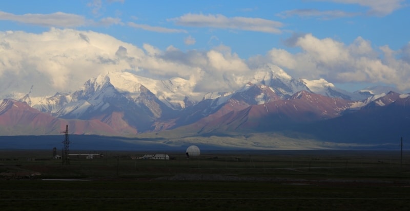
The most famous pass through the Alayokiy ridge is Taldyk pass (3651, and according to other sources - 3680 meters). Since 1932, the Osh-Khorog highway has been passing through it. The vast array of the Zaalaysky ridge is even less accessible and far from all has been studied in detail.
Until 1932, only two passes were known in it - Kizyl-Art (4,444 meters high), through which a road was laid in the Pamir that year, replacing the old wheel road created in 1891-1892 by the Russian Pamir detachment, and Ters-Agar - in the western part of the ridge, leading to the Altyn-Mazar tract, from where you can get: up the Muksu river to the tongue of the Fedchenko glacier; moving down the river - to Karategin and further to central Tajikistan.
Along the rivers Kaindy and Balyand-Kiik from Altyn Mazar there are trails to the Eastern Pamir. In the east, the Alai Valley (or, as it is called here, Bash Alai, that is, the “Head of the Alai”) begins at the very borders of China, where the gentle Tau-Murun ridge passes.
Gradually declining to the west, along the Alai valley, the red-water river Kizyl-su runs from Tau-Murun. At the western end of the Alai valley, where Kizyl-su enters the hills, the ancient Kyrgyz fortress Daraut-Kurgan was long known. The district center created here in recent years has turned into a large comfortable village.
The landscape of the eastern part of the valley is typical of the alpine steppe. Here, on the intermountain plateau, the climate is harsh and cruel. Crops are impossible here, only grasses are dense and plentiful: succulent alpine grasses, excellent pasture for livestock - formerly Kyrgyz nomads, nowadays - wealthy collective farms of Kyrgyzstan, Uzbekistan and Tajikistan; in summer, huge flocks and herds that belong to even the remote collective farms of Ishkashim, Vakhan, Shugnan gather on the magnificent pasture pastures of Alai.
The climate of the valley is subject to a gradual decrease from east to west. In the west, there are many Kyrgyz villages, the climate is much milder, cereals are sown there - rye and barley, there have always been summers, winterings. From there it is already possible not to go down for the winter or to side gorges protected from violent winds.
The western part of the valley is characterized by a landscape of mountain semi-desert. But there is still a third landscape in the Alai Valley, it is observed everywhere in it - this is a special landscape of deposits of ancient ancient glaciation.
In an era remote from us, the entire Alai valley was covered with an ice stream - a gigantic ice armor fettered it all from top to bottom.
Descending from the crests of the Zaalaysky ridge, the lateral glaciers stretched, bending, for fifty kilometers each. All of them closed at the bottom into one powerful massif, which slowly crawled along the foot of the ridge along the valley, following its smooth slope from east to west.
This ice armor weighed billions of tons, and moving between two ridges - Alai and Zaalaysky, he plowed a bed, which deepened under its exorbitant weight as the crushed rocks were carried to the west. Nevertheless, this bed remained skewed, tilted to the north, because the Zaalai ridge was higher than the Alai, because there were almost no glaciers on the southern slope of the latter, while the northern slope of the Zaalai ridge was completely covered by ice flows.
Descending from the steep slopes to the north and gradually, due to their own gravity, turning along the slope of the valley to the west, they carried on themselves the huge rocks clouded by them. A stone mess cluttered the left side of the valley, further increasing its slope.
Therefore, all the water generated from the gradual melting of glaciers rolled down to the right side of the valley and flowed along the foot of the Alai Range - the Kizyl-Su River - the only river that collected all the melt water from two giant parallel ridges between which the valley stretched.
Only where the Zaalai ridge was cut from top to bottom by the Muk-su River, flowing from another colossal glacial system - the Fedchenko Glacier system, the waters of two rivers merged. Gradually, the Alai “Foot Glacier” was melting, the side glaciers feeding it were retreating, leaving behind a huge pile of moraine piles.
The “Glacier of the Foot” was dying slowly, it seemed to be struggling for its existence for a long time, it was either very close to melting, it was again gaining strength, increasing in size. The periods of this titanic struggle - the periods of offensives and retreats - did not pass without a trace.
Her evidence was moraine deposits and longitudinal spurs in the valley. Moraine deposits have survived to our days in all their freshness, it can be judged by how many times the glaciation repeated, how many times it disappeared. The gorges of the ranges and the valley itself tell about this to those people who know how to peer into the eyes of the researcher in their original and instructive forms.
Finally, the "Foot Glacier" disappeared. But all that he carried on himself, everything that he crushed, crushed, threw, pushed together, - his giant moraine inheritance - remained in the form of gigantic rocky barriers blocking the valley, in the form of countless hills, mounds and incised into the glacial glaciers "Shoulders."
On the eroded sediments of the epoch of the first - integumentary - glaciation, everything that later glaciations left behind lies at rest. Scientists have four stages, but all of them were not so powerful, all were unable to recreate the ancient "Glacier of the Foot."
Ice was getting smaller and smaller on the slopes of the Zaalai ridge and in the Alai valley, the line of snow that fed the glaciers was rising higher - it was approaching the ridges of the ridge. And finally, the era of modern glaciation has come.
Its size and power can not be compared with the size and power of the ancient.
Glaciers descending along the northern slopes of the Zaalai ridge no longer reach the Alai valley. They crawl, filling with themselves the transverse gorges and valleys of the ridge - tight, deeply incised; they suddenly break off at a height, laying their short and wide tongues on the ledges formed by the ancient moraines.
They look like icy curved snakes hanging their flat heads over the Alai valley - all the more like snakes that their bodies are independent and separate, they have no lateral tributaries. They do not go down below four kilometers above sea level, not reaching the Alai Valley for half a kilometer by a plumb line, sometimes almost a kilometer.
True, among them there is a glacier of another type - a complex, branched, formed from a number of tributaries Korzhenevsky valley glacier, the largest of all the modern Zaalai glaciers; he descends below others, but he is an exception.
Authority:
"Traveling in the Pamirs." Pavel Luknitsky. Publisher of the Central Committee of the Komsomol, "Young Guard" 1955.
Photos by:
Alexander Petrov.