


![]()
Вы здесь
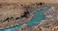
River Karadarya.
Rivers of the Ferghana Valley.
“Frankly, a traveler needs to be born, and one should go into the distance only in years of full strength”
Peter Kozlov.
Osh hiking with english-speaking guides.
Karadarya River (Kyrgyz. Kara-Darya, Uzbek. Qoradaryo, Khoradaryo) is a river that flows through territory of Osh region in Kyrgyzstan, in Andijan and Namangan regions in Uzbekistan. Karadarya River belongs to Syrdarya River Basin.
One of the largest rivers flowing into the Syr Darya. The length of Karadarya is 180 kilometers, along with the left component of Tar - 318 kilometers. The basin area is 30,100 square kilometers, Karadarya is fed by the waters of snows and glaciers.
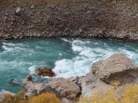
The average annual flow rate is 136 cubic meters per second, the highest flow rate observed at this point is 265 cubic meters per second (1969), the lowest flow rate at this point is 68.4 cubic meters per second (1975). 55% of annual runoff falls between March and July.
The river is most full in June, and the least full in winter. Water has a turbidity of 1 kilogram per cubic meter. In some winters, Karadarya freezes for a short time off the coast, and ice drift is observed. Karadarya is formed by the confluence of the Tar and Kara-Kuldzh rivers, which begin from the southeastern slope of Ferghana and the northern slope of the Alai Range.
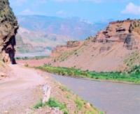
The beginning point of Karadarya is located at an altitude of about 1150 m. a. s. l., near the village of Kenesh, Osh Oblast, Kyrgyzstan. Karadarya flows in a general westerly direction. Up to the Andijan reservoir, Karadarya runs along a valley with a width of 0.5 to 4-5 kilometers.
Then the valley narrows sharply, forming the now flooded Kampyrravat gorge. Here, the river is blocked by a dam, forming the Andijan reservoir. Below Karadarya goes to the Ferghana Valley, passing to the lands of the Andijan region of Uzbekistan.
The border of Andijan and Namangan regions was drawn along the pre-estuary section of Karadarya. Outside the city, Balykchi merges with the Naryn River at an altitude of 396 m. a. s. l. Karadarya on the left and Naryn on the right form the Syr Darya River.
After reaching the lands of the Ferghana Valley, the waters of Karadarya are intensively used for irrigation. Its waters are fed by the large canals of Shahrihansay, Andijanisay and Pakhtaabad. From the river begins the Karadarya tract of the Great Ferghana Canal.
Karadarya has several large tributaries: (on the right) Zhazy, Kugart, Kara-Unkyur and Mailuu-Suu, (on the left) Kurshab, Ak-Buura, Aravan-Say.
Authority:
http://www.cawater-info.net/bk/water_land_resources_use/docs/rivers.html
Photos by
Alexander Petrov.