


![]()
Вы здесь
Gorge Ybykty - Kabyrga

Tours to Mangyshlak.
“If you want to get an idea of all types of deserts in the world, black rocky bare mountains, sparkling whiteness or pale pink, artsy“ stone desert cities ”with intricate giant towers, obelisks and castles ... if you want to see everything relief forms of sands and all types of salt marshes, to see classic examples of cuestas and chinks, to visit dry hollows, sinking 130 meters below the ocean level, to taste the hardness of takyrs and see the gloom of the rocky gammada ... you will not find a better place than Mangyshlak. In this country, in a small space, as in a reserved box, the whole arsenal of the most diverse manifestations of the nature of the deserts is collected..."
B.A Fedorovich, a prominent Russian researcher of the desert (1954, p. 273).
Best tours of Mangistau.
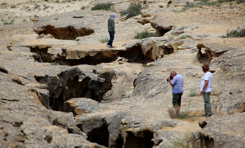
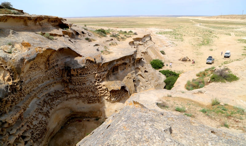
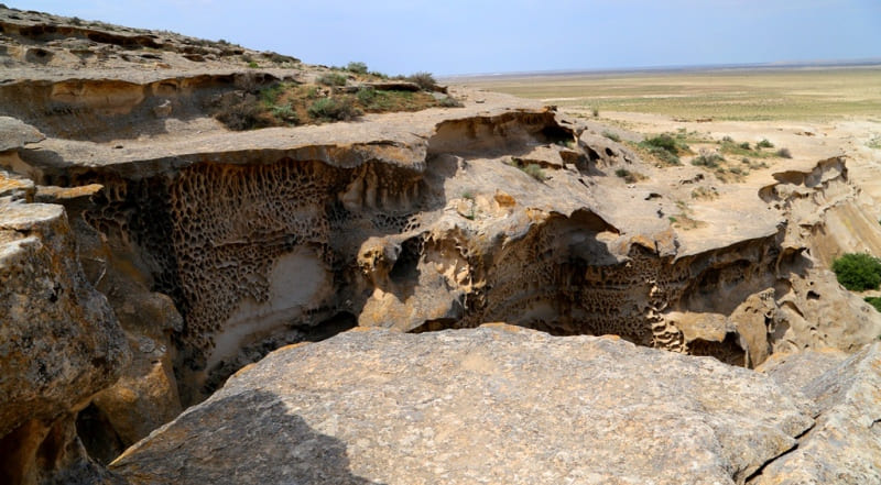
Gorge Ybykty - Kabyrga is located at an altitude of 58 meters above sea level, located in the southwestern part of the Kabyrga tract, in the central part of the Mangyshlak peninsula, 12.6 kilometers from the Karaman ata necropolis to the east and slightly to the north, 54.9 kilometers to the north - east of Aktau, 9 kilometers east of the small village of Emir and 5.4 kilometers south and slightly west of junction 15 in Tupkaragan district of Mangistau region.
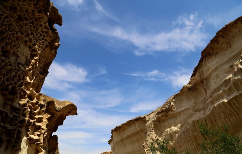
The length of the gorge is small, only 245 meters. Flood and rain streams of water rush into this narrow gorge from the northeast and, passing through the gorge, exit it in the western part. The gorge is very narrow.
At the beginning, in the western part, the width of the gorge reaches 10 meters, in the middle part, the upper part of the gorge reaches a width of 3 to 4 meters, and at the end, in the southeastern part, the width is 1 meter.
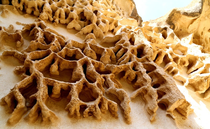
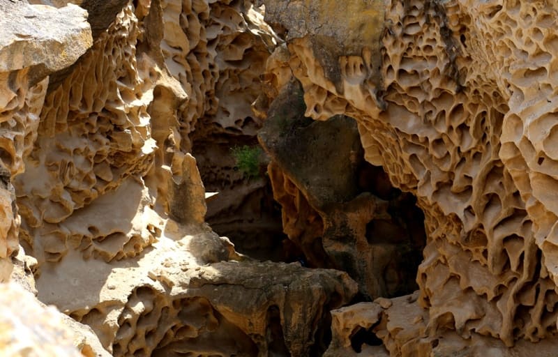
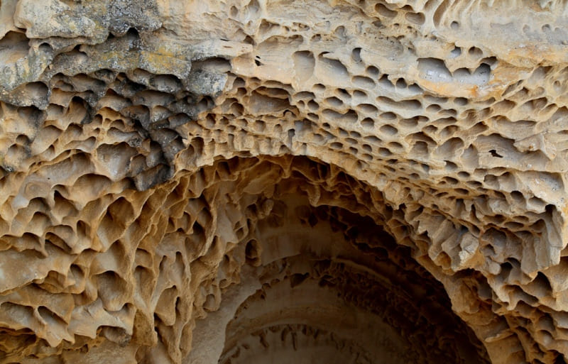
The bottom of the channel of the gorge dries out for a long time after water flows, this is due to the fact that the sun's rays do not get there at all, and the blowing of the gorge is very low. The Kabyrga tract keeps unique tafoni in the labyrinths of canyons, which were formed on the vertical surfaces of rocks and look like clusters of holes as a result of weathering.
The etymology of the word tafoni is unclear. Tafoni can come from the Greek word "taphos", crypt, grave, in Sicily and Corsica, this word means - "window, hole", or from the Italian "tafonare", meaning drilling. The earliest known publication of the term tafoni was in 1882.
On Mangyshlak, tafoni are found in the Kapamsay canyon, in the vicinity of the necropolis and the Shakpak-ata underground mosque. What were once fissures in the rock are now thin but strong walls of mineral deposits.
Since the calcium content in the fractures turned out to be much higher, the process of rock weathering occurs unevenly, weakly cemented pockets are destroyed faster than their walls. The result is a complex, lacy structure that often resembles a honeycomb.
Often, tafoni are formed in a less durable layer of sandstone located between two other layers. Recognized sub-categories of tafoni include honeycomb, stony, alveolar (less than 2 cm), lateral, basal, nest, and relict tafoni.
Tafoni usually develop in siliceous or coarse-grained sandstones or coarse crystalline (granites) rocks. They have also been found in lacustrine silts, tuffs, and conglomerates. They can be found in all types of climates, but are most productive in salt-rich environments such as deserts and coastal areas.
Common factors in the environment they are in are high salt concentrations and frequent or occasional desiccation conditions. There are many explanations for the origin of tafoni. These include marine forcing, wind erosion, mechanical weathering due to transient temperature fluctuations, chemical weathering and saline weathering.
Since the 1970s, most scientists have argued for salt weathering as the main explanation for the formation of tafoni. The origin of tafoni is now believed to be the result of a complex interplay of physical and chemical weathering processes that include salt weathering, cyclical moisture, and drying.
Geographic coordinates of Gorge Ybykty - Kabyrga: N43°56'02.46" E51°43'27.62"
Authority and photos by:
Alexander Petrov.