


![]()
Вы здесь
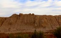
Ancient settlement of Kuraily-asar.
Travel to Kazakhstan.
"A brilliant story is rarely completely true."
S. Johnson.
Sights of Kazakhstan.
The Eastern Kum-kala settlement (Kum-kala II) is located in the Karmakshy district of the Kyzylorda region, 14.5 kilometers north-west of the Turbagabet village and 49.4 kilometers south-west of the Zhosaly village.
The Kuraily-asar settlement is located 4.2 kilometers east of the Bazar-asar settlement. The settlement does not have regular contours, only the northern undeveloped third of the settlement approaches a rectangle in plan.
The entrance gate was located between two flanking towers, on the eastern side of the fortress. Along the edges of the fortress walls, corner towers can be traced, oriented to the cardinal points, and noticeably protruding beyond the boundaries of the fortress walls.
Between the corner towers, every 25-30 meters there were smaller towers, also protruding beyond the walls. The ruins of the ancient settlement Zhalpa-asar are located 4.2 kilometers southeast of the Kuraily-asar settlement.
Geographic coordinates of the Kuraily-asar settlement: N45 ° 06'34.09 "E63 ° 45'15.78"
Authority:
https://sketchfab.com/3d-models/079--3abd29f9f2014039bd65a01b5745a47b
Photos by
Alexander Petrov.