


![]()
Вы здесь
Burial ground Tagisken.


Tourist routes of Kyzylorda region.
"The less a man needs, the closer he is to the gods"
Socrates.
Guidebook to monuments of Kyzylorda region.
The Tagisken burial ground is located on the left bank of the drying up channel of the Zhanadarya in the Karmakshy district of the Kyzylorda region, 74.1 kilometers southeast of the village named after Kokembaev and 62.6 kilometers south-west of the village of Akkyr, in the vicinity of the Tegisken hill with a height of 110.2 meters above sea level.
Tagisken (sometimes the name Tugisken is used) is a burial ground on the plateau of the same name near the ancient channel of the Syr Darya - Inkardarya, in the Kyzylorda region. Belongs to the Late Bronze Age. Consists of two complexes - north and south.
Discovered in 1959 by the Khorezm expedition of the USSR Academy of Sciences, it was also investigated by it in 1960 - 1963. In the southern group, the Saka burial mounds dating back to the 7th-6th centuries are concentrated. BC. and the northern group, where the Late Bronze burial structures are located - adobe mausoleums dating back to the IInd - Ist millennium BC.
Northern Tagisken - the necropolis of the tribal leaders of the IX - VIII centuries. BC e. with burials in adobe bricks mausoleums. The burial structures of the relatives and close associates of the leader are attached to the mausoleums.
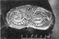
In the burials, gold and bronze earrings, carnelian beads, bronze arrowheads, and earthenware were found. In addition to stucco vessels, there are also those made on a potter's wheel, with polished and carved geometric patterns.
The material culture traces the traditions of the local cultures of the Late Bronze Age and links with the higher culture of the south of Central Asia. Southern Tagisken is a burial mound of the Saka tribes of the VIIth - Vth centuries. B.C.
Burials were carried out in pits, some of the bodies were cremated. The graves contained horse harness sets, bronze arrowheads and mirrors, stone altars, long swords in wooden scabbards, molded earthenware, etc.
Gold plaques and plates, as well as bronze items of horse attire, are made in the Scythian animal style. In material culture, connections with the Savromats of the southern Urals and the Sakas of the more northern steppes of Kazakhstan are noted.
The Tagisken burial ground is of particular interest, since it gives us two complexes of different times, but at the same time chronologically related to each other. First, it is a Late Bronze Age necropolis dating from the IXth - VIIIth centuries. BC e., with possible small deviations in both directions.
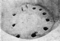
Here, in large mausoleums, built of rectangular mud bricks, wood and reeds, the layout of which was based on a circle, the leaders of the tribe rested. Rectangular brick fences were attached to the mausoleums, where the relatives and confidants of the deceased were buried.
In the mausoleums, the ritual of cremations was performed. The extremely rich grave goods, from which mainly dishes have come down to our time, since the bulk of things were plundered in antiquity, demonstrates the presence of two components in the culture of the population who buried their dead here.
On the one hand, this is a local component, analogies to which we find in the Dandybaev-Begazin complexes of Central Kazakhstan, and in which the Andronovo jet is clearly visible. On the other hand, we find here dishes made on a potter's wheel. Its shape and surface finish lead us south, into the area of the spread of agricultural crops.
To this it should be added that the method of building mausoleums from adobe bricks could also be brought here only from the south, where it was widely used in construction since ancient times, and, as you know, rectangular standards prevailed.
The origin of this second component is not yet entirely clear to us. Here, on the Tagisken plateau, south of the mausoleums, there is a Saki burial mound. This southern Tagnsken group, in turn, is divided by a small hollow, about 100 meters wide, into two complexes.
The first of them, the closest to the mausoleums, contains 9 mounds, of which 8 have been excavated by us. The second, southernmost complex contains 27 burial mounds, of which we excavated 26. In general, the Saka burial ground dates from the VIIth - Vth centuries. BC e., and the mounds of the Vth century. BC e. grouped in the southernmost part of it, and the more ancient ones are located at the northern end, closer to the ancient mausoleums.
In total, 38 Saka mounds were excavated at Tagisken (4 mounds are located on the territory of an ancient necropolis), and at Uygarak - 50. Uygarak kurgans, located 30 km east of Tagisken, date back mainly to the VIIth - VIth centuries. BC e. and give material similar to Tagisken.
An analysis of the structures and rituals of the Saka burials of Tagisken with the involvement of relevant materials from the more ancient Tagisken complex will not only give us the opportunity to trace the history of the tribes that inhabited the southern part of the Sydarya delta for quite a long time, but also outline possible ways of the formation of the culture of the Saka tribes in this territory.
Burials of the 6th, and often the VIIth - VIth centuries. BC e. on South Tagisken are represented by two types.
The bulk of the burial consists of ground burials in sub-rectangular burial pits with an area of 2.5 - 3 x 2 - 2.5 meters, a depth of 2 meters, oriented in most cases along the east - west or east - north - east - west - south - west.
Geographic coordinates of the Tegisken burial ground (northern): N44 ° 15'55.31 "E63 ° 39'47.29"
Geographic coordinates of the Tegisken burial ground (southern): N44 ° 15'19.59 "E63 ° 39'33.83"
Authority and phptps:
https://swordmaster.org/2015/01/17/saki-iz-nizovev-syr-dari-po-materialam-tagiskena.html
Tolstov S. P., Itina M. A. “Saki from the lower reaches of the Syr Darya” (based on materials from Tagisken). Soviet archeology. No. 2. M., 1966.