Вы здесь
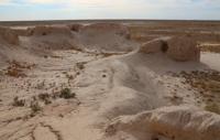
Ancient settlement Tokseit-kala.

Excursion tours across Kazakhstan.
"History is a novel that was, a novel is a history that could have been"
Goncourt.
Tours along the Great Silk Road.
The Tokseit-kala settlement is located in the Syrdarya district of the Kyzylorda region, 28.8 kilometers southwest of the Inkardarya village and 24.7 kilometers southeast of the Satbay village. The site of the settlement is square (90 x 90 meters) and is oriented to the cardinal points.
The monument from the northeastern part adjoins the bed of the Inkardarya river, where it bends. In the same part of the settlement there is a fortified house - a citadel (measuring 30 x 30 meters), the height of the walls is 0.5 meters.
The lifting material from the city of Tokseit-kala is similar and identical to the ceramic complex of Syrlytam-kala and Zangar-kala.
Geographic coordinates of the Tokseit-kala ancient settlement: N44 ° 28'10.07 "E64 ° 32'54.07"
Authority:
A.A. Tazhekeyev, R.T. Darmenov. "Bulletin of KazNU". 2012. Almaty
ttps://articlekz.com/article/7260
Photos by
Alexandr Petrov.


