


![]()
Вы здесь
Medieval settlement Oxus.

Stay in Turkestan region.
“Guz cities are numerous. They stretch one after another to the north and east ”78. The largest of the Oguz cities were Jend, Yangikent (Zhankent), Barchynkent, Hora, Erkebay, Kuigenkala, Kumkala"
Al-Idrisi.
Information about monuments of Turkestan region.
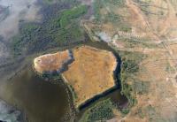
The medieval settlement of Oxus is located 3.7 kilometers from the left (eastern) bank of the Syrdarya river in the west Zhamansuat valley, 9.8 kilometers north and slightly west of the village of Mayakum and 20.2 kilometers south-east of the village of Kolkudyk in the Otyrar district of the Turkestan region.
In the historical literature, the Oxus settlement is identified with the medieval city of Vesij, known as the birthplace of the outstanding scientist Abu-Nasr al-Farabi. In the XIII century, the city apparently had a different name - Zernuk.
It was located at the crossing over the Syr Darya. In the middle of the 13th century, the city of Zernuk was mentioned in the description of the journey of the Armenian king Getum. An interesting etymology of the name Zernuk is given among the terms denoting various kinds of chigiri - water-lifting structures.
Investigations of irrigation systems have revealed several chigirny and developed chigir irrigation in the area of the settlement, which is an additional argument in favor of localizing Zernuk on the site of the Oxus settlement.
The Oxus settlement and the agricultural settlements located around it were supplied with water from the Ak-Aryk main canal, the source of which was located 7 kilometers southeast of the Oxus on the Syrdarya.
The settlement is a two-tiered mound. The citadel is in the form of a hillock with a height of 1.35 meters, with sides: north-east - 90 meters, north-west -75 meters, south-east - 180 meters and south-west - 150 meters, located in the north-east part.
The lower part - shahristan has the dimensions of the sides. north 165 meters, east 200 meters, south-south-east 150 meters, south-west 195 meters and west 180 meters. The height of the shahristan hillock is 3 - 5 meters.
Along the perimeter, the shakhristan was surrounded by a wall with towers at the corners and perimeter every 30 - 40 meters. The remains of the towers are traced in the form of a hill 1.5 meters high. There is a moat around the settlement, the depth of which is currently 2 - 3 meters.
Inside the settlement there are 2 entrances located in the eastern and southwestern walls. An unfortified rabad adjoins the central ruins from the south and west, through which the main canal runs. Rabad area is about 20 hectares.
In 1900, N.V. Rudnev. In 1947, the survey was carried out by YuKAE under the leadership of A.N. Bernshtam, in 1975 by the South Kazakhstan integrated archaeological expedition (K.A.Akishev, K.M. Baipakov).
On the basis of the lifting material collected by the expedition, the settlement was dated to the 1st - 16th centuries. AD Patskevich G.I. identifies the Oxus settlement with the city of Vesidzh - Zernukh.
Geographic coordinates of the medieval settlement of Oxus: N42 ° 57'05.55 "E68 ° 01'56.31"
Authority and photo:
http://otrarmuseum.kz/rus/oksizkalajurtru.php