


![]()
Вы здесь
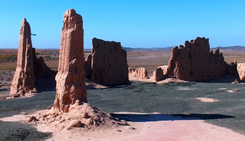
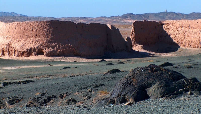
Dzhanpyk kala ancient settlement.
Tours Karakalpakstan.
“The Arabs say it is true, here I am with them:
It is not criminal to drink wine at the time of spring bloom;
To make friends with a young peri from Hallukh now -
So that she, like a Chin idol, caressed the eyes with beauty,
To enter with a languid gait into our intoxicated, cheerful circle,
To draw on glasses: "Are you, daredevil, a welcome friend?"
Bade Balkhi, translated by D. Vinogradov.
Drive from Nukus to Dzhanpyk kala.
Dzhanpyk Kala ancient settlement is located in southwest of Sultan-Uvais mountain range and in northwest of small mountain range Aktau, 564 meters from the right (northern) bank of Amu Darya River, 8.3 kilometers southeast of village of Karatau and 10.4 to east and slightly north of village of Kuyuk-Kupyr in northeastern part of Badai-Tugai nature reserve in Karauzyak district of Republic of Karakalpakstan.
The settlement dates back to the X - XI centuries, XIII - XIV centuries. AD The Dzhanpyk Kala settlement is one of the picturesque monuments of the right bank of the Amu Darya. Closely adjoins the northern part of the Lower Amudarya Biosphere Reserve.
The vast territory of the reserve is located to the south on the other side of the Kok Darya River. The distance from the city of Beruni on a straight road through the village of Aktau is 51 kilometers, along the main asphalt road it is 77 kilometers.
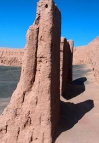
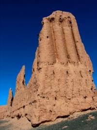
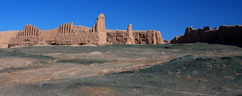
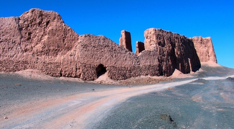
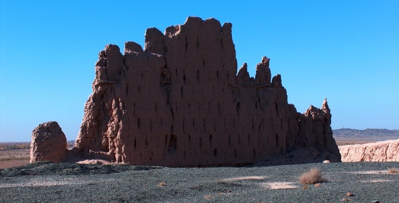
The Dzhanpyk Kala settlement is located 7.1 kilometers southeast of the Gyaur Kala fortress and is reached by the same route. The site of the settlement has a complex configuration. In the eastern part, the citadel has been preserved in the form of a rectangle of pakhsy walls.
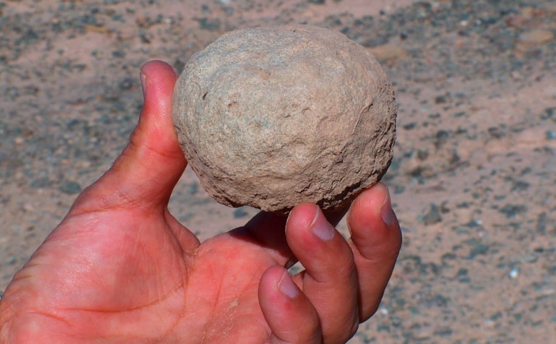
The walls are decorated with closed semi-columns and the tops end in pairs of stepped arches. Archaeological excavations made it possible to clarify the chronology of the settlement. The oldest pottery dates back to the IVth century BC. - Ist century A.D.
The date of the last settlement on the site is determined by coins of 1319-1320 and 1345-1346. During the excavations, numerous finds were discovered, previously brought from various countries of the East and West (China, Egypt, Russia, Europe, India).
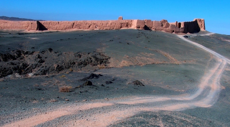
The castle mound served as a port town in the Middle Ages. On the outskirts of Dzhanpyk Kala, you can see the endless expanses of the Badai Tugai reserve. The largest researcher of the history of Khorezm S.P. Tolstov, who discovered dozens of unique ancient settlements in the lower reaches of the Amu Darya for European science in the 30s and 50s of the last century, considered the medieval fortress Dzhanpyk Kala at the foot of the Sultanuizdag ridge (popularly known as “Karatau”) to be the most beautiful and exotic archaeological monument in the region.
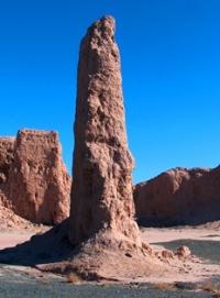
Closer to the river bank, on one of the peaks, a sharp spire of a high clay tower with clearly man-made, albeit crumbling, outlines is suddenly discovered. The watchtower, visible from the Nukus-Beruni highway, indicates the direction to the fortress, separated from the bank of the Amu Darya by the green stripe of the Badai-Tugai reserve - the kingdom of waterfowl, pheasants, wild cats, jackals and a refuge for noble Bukhara deer.
The fortress, standing right on the border of desert foothills and an impenetrable riparian forest, once closed a strategically important passage between waterless mountains and a navigable river, whose fertile silt served as the basis for the birth of centers of agricultural civilization two thousand years BC.
The first sedentary culture arose here on naturally irrigated coastal lands, developed in close contact with hunting and nomadic peoples - first from the Urals, then the Scythian tribes of the Saks and Massagets. Subsequently, the relationship between nomads and farmers was extremely complex and dynamic.
They fiercely feuded with each other, at the same time conducted a mutually beneficial exchange, and united to jointly repel the conquerors. According to archaeologists, the oldest remains of pottery in the vicinity of Dzhanpyk Kala can be dated around the IVth century BC, when Khorezm had already freed itself from the power of the Persian Achaemenid state and escaped the conquests of Alexander the Great.
This was the time when the most stable dynasty of local rulers from the legendary Afrig family established themselves on the right bank of the Amu Darya, maintaining relative independence from the great powers of antiquity until the early Middle Ages.
The construction of the powerful fortress walls of Dzhanpyk Kala that have survived to this day is dated by scientists from the 9th-13th centuries AD, when a wave had already spread throughout Central Asia Arab conquests. For the right-bank Khorezm, this was still the time of the Afrigs.
Kuteiba ibn Muslim, who conquered the fragmented principalities of Bukhara and Sogdiana in 709, following his favorite tactics, waited for an internal strife to break out in Khorezm, which was started in 712 by the rebellious son of the ruler Khurrzad.
Khurrzad, opposed the old aristocracy, relying on the poor, infected with sectarian sentiments, almost the same as it was in the Vth century, during the time of Mazdak in Sassanid Iran. After the first campaign of Kuteiba, the people revolted again and killed the ruler, and the Arabs had to return to put his faithful son, Askadjamuk II, on the throne, who recognized his vassal dependence on the Caliphate.
Only at the end of the 8th century did his grandson Shaushaffar adopt the Islamic name Abd Allah. When the dynasty of Arab governors of the Mamunids had already established themselves on the left bank of the Amu Darya, on the right bank, in ancient Kyat, the last of the Afrigs still ruled until the end of the Xth century.
It is to this period that the main fortifications of Dzhanpyk Kala seem to belong, in whose massive conical bastions and double walls a medieval fortress is easily recognizable. The remains of the high walls of the inner citadel, decorated with a semblance of antique columns, retain their affinity with the architecture of the famous palace and fortress structures of the thousand-year-old African empire, which preceded the fortress at the foot of Karatau by five to seven centuries.
The building material in the region has not changed during this time.
Like the gigantic Ayaz kala and Toprak kala in the vicinity of ancient Kyat (Kas), the relatively small fortress Dzhanpyk is made of pakhsa - large blocks of compacted clay. Only the foundations of the walls and the entrance arches are here and there reinforced with masonry from unhewn boulders, but even then, perhaps, not because of a change in building traditions, but because there was enough stone in the surrounding mountains.
At the end of the 11th century, the dynasty of the Great Khorezmshahs came to power in Khorezm, whose founder Kut bat-Din Mohammed I achieved de facto independence from the Seljuk sultans. His descendant Ala ad-Din Tekesh repelled the invasion of the Karakitai and almost seized the throne of the Baghdad caliphs.
His son Muhammad II owned a huge empire stretching from Kashgar to the Caucasus and the Persian Gulf. But this power was crushed by the invasion of the hordes of Genghis Khan. However, the latest archaeological finds within the walls of Janpyk Kala date back to around the forties of the XIV century.
This may indicate that the fortress and river port on the banks of the Amu Darya did not undergo final destruction under the Mongols, did not survive the subsequent period when the rulers of the Timurid empire competed for Khorezm with the khans of the Golden Horde.
It is also possible that Dzhanpyk kala was abandoned and desolate when the wayward river took its course far from its walls, giving rise to today's miracle of nature - a many kilometers strip of floodplain wilds of Badai-Tugai, whose protected status today protects the peace and secrets of this fabulous place.
Currently, the monument is a historical and archaeological site for cultural and tourist trips.
Geographic coordinates of settlement of Dzhanpyk-kala: N42°01'37 E60°19'36
Authority:
Dospanov October. “Improving the efficiency and sustainability of the functioning of the created Nizhne-Amudarya State Biosphere Reserve”. Nukus - Tashkent. 2013.
Photos by:
Alexander Petrov.