


![]()
Вы здесь
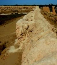
Fortification Ayaz kala №3.
Tours and excursions in Karakalpakstan.
“... under the name Kangyuy, which is identical with the Kangkha of the Avesta, Khorezm is hiding. The very term "kangha", associated with the Iranian (and all-European) basis of "kan", whence the Uzbek and Tajik "kan" - a channel, and the word "channel" itself can be translated as "the country of irrigation ditches" or "Country of streams", delta; it is characteristic that the Helmand delta in Seistan is called Miyan-i-Kang; in the south-west of Khorezm, the southernmost channel of the Sarykamysh ancient delta of the Amu Darya still bears the name of Kangadarya, and the adjacent hill is the name of Kangagyr. " , german mouthpiece! (strait, ditch), English glanders! etc. are associated with the same term. And the term "kang" then simply meant "river", "channel"
S. P. Tolstov. "In the footsteps of the ancient Khorezm civilization" M. - L - 1948. p. 146.
Bus excursions in Karakalpakstan.
Fortification Ayaz kala № 3 (fortress in the wind) is located on a natural hill, located in the southern part of the Ayazkol salt marsh and in the waste part of the Pashakhaikum sands, 20.1 kilometers to the north and slightly east of the village of Bustan, 19.4 kilometers to the north. east of the Shark-Yulduzi village, 18.8 kilometers north-west of the Dzhambaskala village and 41.9 kilometers north-east of the city of Beruni in the Ellikala region of the Republic of Karakalpakstan.
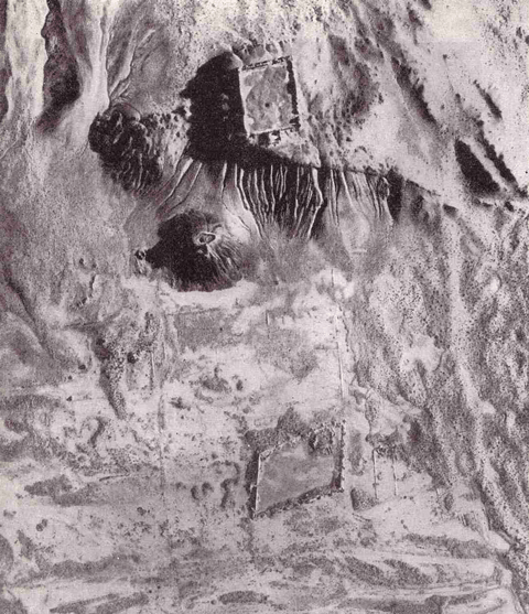
It was first investigated in 1939 - 1940 by the Khorezm archaeological expedition led by S.P. Tolstov. Three stand out among the large group of settlements. The first of them is the fortification of Ayaz Kala No. 3, with minarets and labyrinths, fenced off by a powerful wall.
Remains of a spacious palace have been preserved inside the fortification. Archaeologist S.P. Tolstov outlined in his book “In the footsteps of the ancient Khorezm civilization. Part 1. " (1948): “Folk legend connects this fortress with the name of the hero - the slave Ayaz, who sought the hand of the princess who lived in the Kyrk-kyz fortress with her forty friends.
The image of the brave and wise slave-hero Ayaz is one of the ancient images of the Central Asian Turkic folklore. A Kazakh legend recorded in the Lower Syrdarya connects this image with legendary events that predetermined the formation of the Aral Sea, the disappearance of the Ustyurt channel of the Amu Darya and the emergence of ancient Khorezm.
According to this legend, in the past there was no Aral, and the Syr Darya and Amu Darya rivers, joining together, flowed through Lauzan, Kunya-Urgench and Aybugir to the Caspian Sea. On the site of the Aral Sea, the Adag people lived, ruled by the cruel and treacherous Fasyl Khan, and the Baisyn people lived on the territory along the Uzboy, headed by Ayaz Khan, a former slave who, thanks to his wisdom and justice, became the ruler of the state.
For the terrible crimes of Fasyl Khan, who dishonored the daughter of one saint, through the prayer of the latter, water flooded the entire kingdom of Fasyl. At this place, the Aral Sea was formed, into which both great rivers began to flow.
Their connected ancient channel dried up, and the people of Baysyn, led by Ayaz Khan, moved to Khorezm and formed a kingdom, which began to be called Urgench. The Adagians and all their cities perished under water, and traces of their buildings can still be seen on clear days at the bottom of the Aral Sea...".
The Ayaz-Kala settlement is a unique historical monument - the ruins of an ancient fortress from the times of the Kushan kingdom. The fortification was built in the III-II centuries BC during the heyday of the Kushan culture.
The fortress played the role of a military fortification, guarding the borders of the kingdom. The place chosen for the construction of the fortress still amazes with its detailed thoughtfulness. The structure is located on the flat top of a 60-meter hill.
The double walls of the Ayaz Kala fortress, built of adobe bricks, are oriented to the four cardinal directions. The outer wall that has survived to this day is 10 meters high and about 2.5 meters thick. The entrance to the fortress, located on the south side, is protected by a labyrinth.
The entrance also has its own peculiarity - it was built with the expectation that the southerly wind ruling in these parts would take out debris and dust from the settlement. This is where the name of the Ayaz-kala fortress came from - “Fortress in the wind”.
Geographic coordinates of Ayaz kala fortification No.3: N42 ° 00'19.84 "E61 ° 01'50.21"
Authority:
Dospanov October. “Improving the efficiency and sustainability of the functioning of the created Nizhne-Amudarya State Biosphere Reserve”. Nukus - Tashkent. 2013.