


![]()
Вы здесь
Ancient settlement of Shurcha.
Travel to Karakalpakstan.
“Today you have no power over tomorrow,
Your plans will scatter sleep tomorrow!
You live today if you are not insane.
You are not eternal, like everything in this earthly world "
Omar Khayyam.
Tours to Western Uzbekistan.
The ancient settlement of Shurcha is located on the site of a occupied modern Muslim cemetery in the northeastern part of Nukus, 2.1 kilometers east and slightly south of the airport, 2 kilometers southeast of Lake Komsomolskoye in the Republic of Karakalpakstan.
The ancient settlement of Shurcha dates back to the IVth - IIIrd centuries BC. BC, on the site of the Shurcha settlement, Nukus is now located. The settlement area covers an area of about 4 hectares. On the northwestern outskirts of the city, traces of powerful fortress walls are visible, forming the shape of a square rampart with a length of 50 - 60 meters.
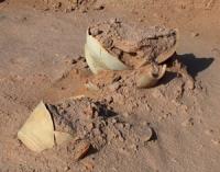
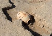
The monument has been repeatedly visited by archaeological researchers. Analysis of archaeological materials makes it possible to establish the stages of its development. The most ancient stage of settlement falls on the early antique period of the history of Khorezm (IV - III centuries BC).
In the IV century BC, on the northern outskirts of the Khorezm state, a number of border fortresses appeared, such as Tok Kala, Gyaur Kala, Ayaz Kala, Burly Kala and others, which guarded the agricultural oasis from the invasion of nomads.
The settlement of Shurcha, in all likelihood, owed its existence to such fortresses, in which the population was hiding from the raids of nomadic pastoralists. No materials from the 1st century were found on the site. BC e. - Ist century AD e., which indicates a break in habitation.
But numerous finds of ceramics of the IInd - IVth centuries A.D. e. talk about the revival of life during this period. Archaeologists associate the end of life at the Shurcha settlement, not with a change in the hydrographic regime of the Amu Darya, as some researchers suggest, but with the military invasion of the nomadic Hun tribes.
Geographic coordinates of the Shurcha ancient settlement: N42 ° 28'47.66 "E59 ° 38'41.44"
Authority:
http://nukus.moymir.uz/history.html
Photos by
Alexander Petrov.