Вы здесь
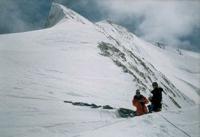
Peak Odinnadsati. Saryjaz ridge.

Peaks in Bayankol gorge.
“The dawn is freezing in the cold sky.
A gray ridge floated away into frost and darkness.
We go forward, and the wind erases the trail.
White around... The wind erases the trail. "
Srym Kuderin. "Along the Glacier".
Summits of Sarydzhaz ridge.
The two-headed peak of Odinnadsati consists of: the eastern peak, 5600 meters above sea level and the western peak, 5437 meters above sea level, located in the eastern part of the main ridge of the Sarydzhaz ridge in the Narynkol district of the Almaty region.
The summit is located between Bayankol Peak 5790 meters above sea level in the east and slightly to the south and Semenov Peak 5816 meters above sea level in the southwest. Peak Odinnadsati is completely snowy and ice-covered, on the southern and southeastern slopes facing the North Inylchek glacier there are rocky outcrops.
Bayankol Central glacier with a length of 4.8 kilometers descends from the northern slope of Eleven Peak. To the south, a little west of the summit of Odinnadsati, descends the narrow, ruptured and swollen glacier of Eleven.
The length of the glacier is 3.5 kilometers, at an altitude of 4165 meters above sea level, it connects with the starboard side of the North Inylchek glacier. The summit is named in memory of eleven Kazakhstani climbers who died in 1955 on the slopes of Pobeda Peak.
In August 1955, two expeditions at once began to storm Pobeda Peak: the Alma-Ata Directorate of the Turkestan Military District, under the leadership of V. Shipilov and the Uzbek Committee of Physical Culture and Sports under the direction of E. Nagel).
The Alma-Ata team climbed to a height of 6930 meters above sea level, but fell under a snow hurricane, out of 12 climbers, only Ural Usenov survived.
Geographic coordinates of Peak Odinnadsati East: N42 ° 17'19.27 "E80 ° 11'01.34"
Geographic coordinates of Peak Odinnadsati West: N42 ° 17'17.81 "E80 ° 10'57.40"
Authority:
Alexander Petrov.
Photos by
Sergei Mikhalkov, Almaty city


