


![]()
Вы здесь
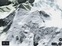
Peak Shater Vostochny.
Mountain routes of Kazakhstan.
“Easy, fast style and a small team - that's what I love about climbing. Why? This is a sportier and more fair game between the climber and the mountain. I respect, but I do not like to attack the peaks with big teams..."
Simone Moreau.
Climbing routes in Meridian Ridge.
The snow-ice summit Shater Vostochny is located at an altitude of 6637 meters above sea level, located in the easternmost part of the Tengri Tau ridge in the Narynkol district of the Almaty region. In the main ridge of the Tengri Tau ridge, at a distance of 6 kilometers to the east and slightly north of the Khan-Tengri summit, there is a summit under the general name of Shatry.
In turn, the peak loses its individuality and is divided into two independent peaks - the Zapadnyi and Shaters Vostochny. Shater Vostochny is located to the dominant peak in the ridge - Khan-Tengri peak, 6.4 kilometers (in a straight line) to the west and slightly to the south.
The distance from the top of the Western Tent to the top of the Shater Vostochny is 1.8 kilometers. From the summit with steep avalanche-prone slopes in the shape of a tent, an almost vertical rock wall breaks off to the west, ending at an altitude of 5692 meters above sea level on the Razorvanny glacier, which is located under the eastern slopes of Khan-Tengri peak.
In the lower part, the glacier is the right tributary of the Demchenko glacier. From the Vostochny Shater summit to the south and a little to the east, the main ridge of the Meridional ridge continues, in which, after 3.5 kilometers, there is the peak of Richard Sorge with a height of 6210 meters above sea level.
From the summit to the southeast flows the sources of the Demchenko glacier, which at an altitude of 4399 meters above sea level merges with the South Inylchek glacier, the sources of which are located on the northern slopes of the Voennyi topografov peak.
The classical route of the summit is rated 5B, 6A by the category of difficulty. The state border between the Republic of Kazakhstan and the Republic of China passes through the top from the south to the north-east.
From the northern slopes of the peak located in Kazakhstan, the headwaters of the Northern Inylchek glacier with a length of 42 kilometers and 11 kilometers across the territory of Kazakhstan begin.
First ascent to Shater peak.
In 1968, the first ascent to Shater Peak was made by a Kazakh team led by G. Kireev.
In 1968, the first traverse of the Shaer peaks - Khan-Tengri - was completed. This traverse of the 6th category of difficulty, made by the team of the CS DSO Spartak under the leadership of B.A. Toporkova. The teams took first place and gold medals in the class of traverses in the Championship of the Soviet Union.
Geographic coordinates of Shater Vostochny peak: N42 ° 13'10.10 "E80 ° 14'58.15"
Authority and photos by
Alexander Petrov.