


![]()
Вы здесь
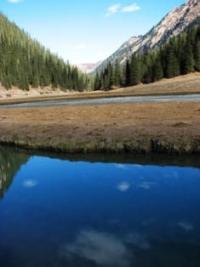
Karakol gorge in Terskey Ala-Too.

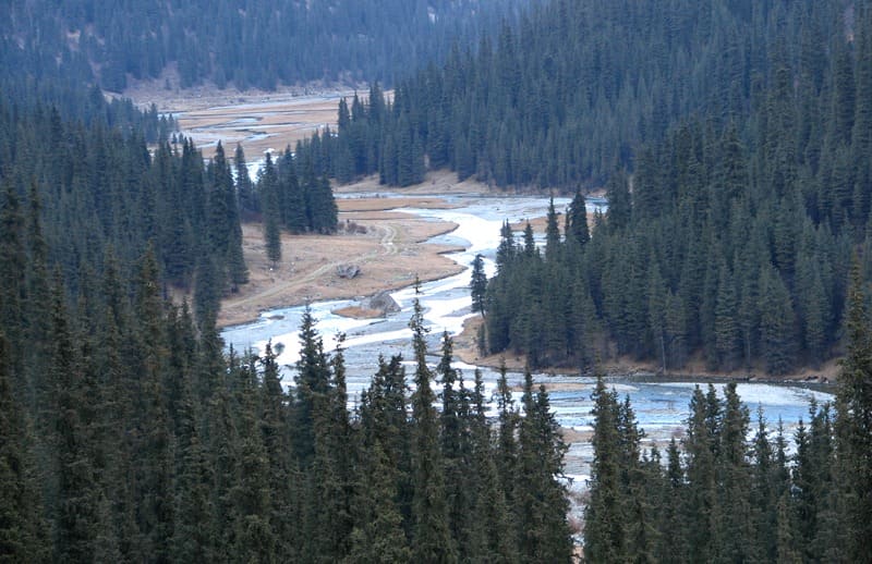
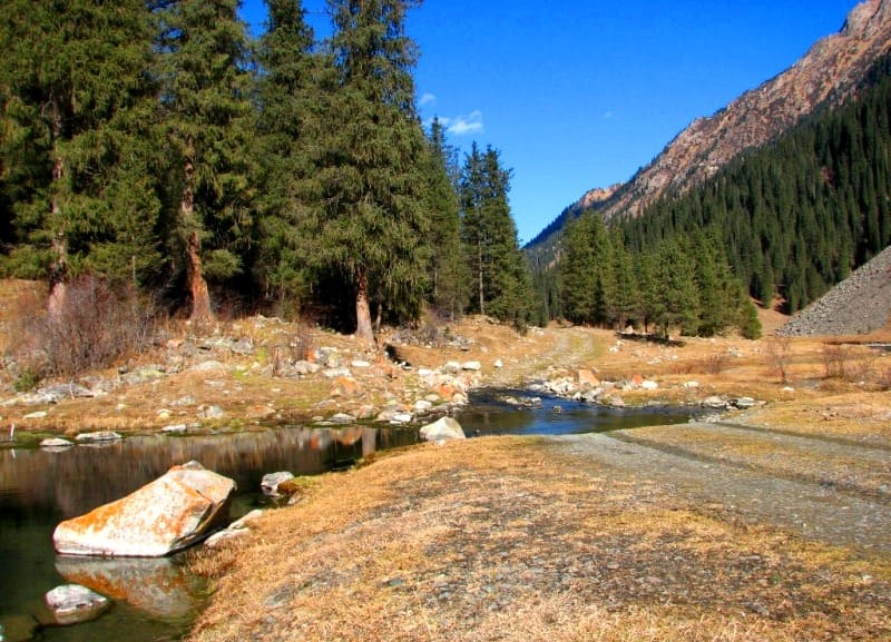
Traveling through gorges in Terskey Ala-Too mountains.
“The life of the Kyrgyz people is full of happiness today,
So, spring enters the song of the poet with a smile ...
Why doesn't he sing this wonderful land -
As if she fell in love with her own son"
Ilyas Dzhansugurov. "In the Kyrgyz Alatau". 1936.
Gorges in Terskey Ala-Too ridge.
Karakol gorge is located on northern slope of Terskey Ala-Too ridge, in Ak-Suu district of Issyk-Kul region. It stretches for more than 40 kilometers from south to north along course of Karakol River.
The width of the gorge on the river floods in the vicinity of the former camp of tourists and climbers, 700 meters higher from the mouth of the Ala-Kel River, reaches 415 meters. The absolute height of the bottom of the Karakol gorge is 2300 - 2700 m. a. s. l.
The upper part of the gorge is a trough valley, there are large glaciers, the middle and lower parts are narrow, “V-shaped gorges. On the slopes of the mountains there are large tracts of spruce forests. Meadow-steppe, tall-grass, meadow landscapes prevail.
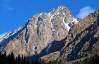
At the exit of the river from the mountains is the city of Karakol (formerly Przhevalsk). The most explored and often visited by climbers are the Karakol and Jety-Oguz gorges. The highest peaks of the Terskey Ala-Too ridge are located here: Dzhigit 5170 m. a. s. l., Karakol 5216 m. a. s. l., Oguz-Bashi 5120 m. a. s. l., Przhevalsky 4283 m. a. s. l.
In addition to the already named peaks, the most famous peaks: Zhukov 4450 m. a. s. l., Telman 4460 m. a. s. l.l, Dimitrov 4450 m. a. s. l., Fucik 4219 m. a. s. l., Gastello 4350 m. a. s. l. and others, where the most interesting routes to the highest walls.
More than 150 routes have been covered here, from the simplest to the most difficult. Routes are usually rocky or combined, less often ice-snow or snow. Elevations up to 1500 meters. The gorge is located south of the eastern end of Lake Issyk-Kul.
The climate in the gorge is much milder than in the Central Tien Shan. The lower absolute heights and the proximity of the Issyk-Kul lake have an effect. There is a lot of precipitation - up to 2000 mm per year. The maximum part of them falls in spring and early summer, but in July - August snowfalls and thunderstorms are frequent.
The most stable weather is in September, but in the mountains at this time it becomes much colder than in summer. The best time for climbing is July-September. The history of the development of the area by climbers. The first ascents were made back in 1927 by a group led by a dental technician from the city of Karakol Grechishkin. In the post-war period, due to the ease of access and the availability of excellent climbing facilities, the area became the site of numerous expeditions for climbers from all over the Soviet Union.
Many routes have been climbed here in the framework of mountaineering championships of various ranks. In the seventies and eighties of the last century, there was a sports mountaineering camp "Ala-Too" located at an altitude of 2545 meters above sea level.
It is possible to get here by car from the city of Karakol. Objects of tourist interest are also: a complex of cascades-waterfalls located in juniper thickets in the Kurgan-Tor gorge, the powerful On-Tor waterfall, cut in two by a rock ledge, located in the gorge of the On-Tor river (left tributary of the Karakol), a cascade of Sharkyratma waterfalls - in the gorge of the right tributary of the Kel-Tor river of the same name (the right tributary of the Karakol River) and numerous moraine lakes.
On the western slope of the Karakol gorge there is a beautiful moraine lake Ala-Kel at an altitude of 3532 m. a. s. l. In 1997, a national park was formed on the territory of the Karakol river valley in order to preserve the unique natural complexes.
The territory of the park is 8450 hectares. More than 700 species of plants, 23 species of mammals, 150 species of birds are represented in the park. There are excursion hiking, horse and car routes developed in the national park. On the slopes of the Karakol gorge, sea buckthorn, barberry, wild rose, mountain flowers and, of course, dense meadow grass grow.
With increasing height, they are replaced by spruce and juniper forests, and subalpine and alpine landscapes complete the composition.
The fauna of the gorge is also interesting: ibex, roe deer, lynx, wild boar, snow leopards, wolves, bears, golden eagles live here.
This is how B.I. describes Karakol gorge. Rukavishnikov in book "Lake Issyk-Kul and Terskey Alatau ridge":
“From Przhevalsk by car you can drive along the foothills of 9 kilometers to the forestry enterprise, further 8 kilometers along the Karakol gorge there is a timber road, which can only be driven by a truck (preferably with two driving axles).
You can get a car for a trip in cash at one of the Przewalsk truck depots.
A few kilometers from the forestry enterprise, in some places along the ravines and ravines on the slopes, a few spruces appear, the road passes three bridges across Karakol and a collective farm dairy farm on the left bank (about a dozen tents).
From here you can leave one by one, two people to Przhevalsk in milk transport vehicles. A timber road ends 7 - 8 kilometers from the forestry enterprise. The gorge becomes picturesque; a spruce forest almost completely covers both slopes, and after a few kilometers around the bend a rocky ridge with a snow ridge separating the headwaters of Karakol is shown in front.
At 10 kilometers from the forestry, the trail crosses two meadows, along which the river freely flows in several branches; the tributary At-Dzhailyau flows into the left (Turkic “Horse pasture”). In an hour's walk from the beginning of the timber road (12 kilometers from the forestry enterprise), a large stone blockage crosses Karakol; for 400 meters, the river rushes about in foam and splashes among the debris of rocks, forming many cascades.
4 kilometers after the blockage, the trail goes to a swampy long meadow (2450 m. a. s. l.) with yurts and tents of shepherds (13 kilometers from the forestry enterprise). The narrow Ayutor gorge (Türkic “Bear tract”) goes to the west, and a masonry has been thrown across the Ayutor at the very edge of the glade.
To the east, the wooded gorge Kurgaktor rises steeply (along it you can climb to Lake Alakul), right in front, 3 kilometers away, the wide gorge Karakol closes the watershed ridge between the sources of Karakol - Kultor and Ontor. In the upper reaches of the short (about 4 kilometers) left gorge, Ayutor, there are two glaciers flowing down from the ridge separating the Karakol and Dzhetyoguz river basins.
Above the left orographic glacier South Ayutor is the Ashutor pass, 3850 meters above sea level, 1B category of difficulty), in the upper reaches of the same glacier, 1 km to the south - the Prizyvnikov pass, 4002 m. a. s. l., 2A category of difficulty), and also in 1 kilometer to the south-east in the same watershed ridge above the Gastello glacier - Mendeleevets pass with a height of 3950 m. a. s. l., 2B category of difficulty).
The Gastello glacier is separated from the South Ashutor glacier by a two-kilometer ridge extending from the Ayutor peak, 4382 m. a. s. l. in the watershed ridge. In 0.5 - 1 kilometers to the east of the Ashutor pass there is a spectacular group of rocky peaks - Issyk-Kul feathers 4275 m. a. s. l.
The three-kilometer stretch of Karakol between the confluence of the Kurgaktor and Ayutor and the confluence of the Kultor and Ontor is very picturesque. The park landscape of the spruce forest is well expressed here: the bottom of the gorge and the lower part of the slopes (especially the left one, along which the trail runs) are covered with forest alternating with sunny glades.
A 600 - 700-meter rock wall rises to the right above the gorge. The left slope is 1/3 - 1/4 of the height covered with a spruce forest, and above the forest, rocks begin, however, among the rocks, up to the ridge, serrated like a saw, they run up in groups, or spruce alone.
The beautiful subalpine meadow along the river is usually heavily poisoned by sheep. 3 kilometers above the confluence of the Kurgaktor and Ayutor, the gorge narrows sharply: here, among the spruce forest, the sources of Karakol merge, at an altitude of 2500 m. a. s. l.: the right one is Kultor (at its source is the Dzhigit peak) and the left Ontor (at its source is the Karakol peak)."

Authority:
“Discovery Central Asia” Travel magazine. Author Sergey Dudashvili. Free application. Issyk-Kul. Naryn "encyclopedia, Frunze, 1991.
B.I. Rukavishnikov. "Lake Issyk-Kul and the Terskey Alatau ridge". Moscow, "Physical culture and sport", 1970.
Photos by:
Alexander Petrov.