


![]()
Вы здесь
Buddhist temple at Kayalyk settlement.
Archaeological Buddhist temples in Kazakhstan.
“They were placed from east to west, and on the north side there was a room protruding like a choir, and sometimes, if the house is quadrangular, this room is in the middle of the house. On the northern side they make a recess in the place of the choir, there they place a chest, long and wide, like a table, and behind this chest to the south they place the main idol, which I saw in Karakorum, the same size as they paint St. Christopher.
On this chest, which resembles a table, they place lamps and sacrifices... In the same way, idolaters, like us, have large bells...” Having then entered the mentioned idol, I found idol priests there. It is on the first day that they open their temples, and the priests put on their vestments and offer incense. They raise the lamps and offer up the sacrifices of the people, consisting of bread and fruits.”
Guillaume de Rubruck, Flemish Franciscan monk, “Journey to the Eastern Countries.”
Buddhist temples on Great Silk Road.
The Buddhist temple at the Kayalyk settlement is located at an altitude of 623 meters above sea level, located in the northwestern part of the settlement and the village of Koyalyk, in the Sarkand district of the Zhetysu region.
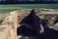
The second important excavation object at the Antonovka site was a Buddhist temple. Before the excavation, the Buddhist temple of Kayalyk looked like a square and rounded mound in plan. It concealed the remains of a building measuring 30 - 35 meters at the base and up to 5 meters in height.
Excavations carried out at this site suggested that it was a Buddhist temple, with a layout typical for this kind of structure. Before the excavations began, it was a slumped hill up to 3 meters high with a square base, oriented at the corners to the cardinal directions.
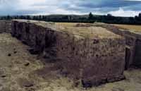
A building made of adobe and burnt brick was discovered, rectangular in plan (16 x 18.5 meters), consisting of a square hall and bypass corridors. In the existence of the temple, two construction horizons can be traced, while the planning composition did not change.
There is an external entrance to the corridor, an internal entrance to the central room, a central (altar) room (hall); a four-way bypass corridor that has a dead end in the southeastern part, dividing the northeastern side of the bypass corridor; corner towers.
The central room has a square plan with sides: southwestern and northeastern - 7.5 meters, northwestern 7.4 meters, southeastern 1.3 meters, and a depth of 4.12 meters from the day surface level was recorded Numerous remains of the roof, burned during the fire and collapsed down, were found.
The following elements are distinguished as part of the temple premises: the central entrance; internal entrance to the central room, hall cella; a bypass corridor that has a dead end in the southeastern part, separating the northeast and southeast sides of the bypass corridor.
The walls of the building were erected from two types of grayish-yellowish mud brick: square 36 × 36 × 8 cm and rectangular 36 × 18 × 8 cm, laid using a combined masonry technique - spoon and poke, “tied”, as well as rows of brick , placed on an edge with a slope.
In the lower part, along the entire perimeter of the walls, two rows of baked bricks measuring 26.5 × 26.5 × 5 cm can be traced, laid on 10 rows of horizontal adobe masonry. The height of the walls reaches about 3.5 meters.
The entrance to the building in the form of openings in the outer wall and the wall of the central hall was located from the southwest. The entrance to the sanctuary is decorated with two wide pylons that stood on stone blocks.
The dimensions of the building along the outer contour of the walls are 16.2 × 18 meters. Its center is a square hall-sanctuary (cella), surrounded on four sides by corridors, however, they are not all through: the southeastern corridor is isolated from the rest by a wall.
The width of the corridors is from 2.5 to 2.8 meters. On the outside corners of the building there were semicircular, protruding towers, preserved only in their lower part, up to a height of 1 meter. Along the entire perimeter, the walls and towers in their lower part were lined with a double row of baked bricks (26.5 × 26.5 × 5 cm), placed vertically.
The largest concentration of wooden roof structures was located in the central part of the hall. Four burnt wooden columns (with a diameter of 0.12 to 0.2 meters) and one surviving one with a height of 0.5 meters were in a vertical state.
These are the remains of wooden columns on which the floor beams of the hall rested. The bypass corridor can be divided into four parts: southeast; southwestern (having exits); northwestern and northeastern (separated by a dead-end wall from the northeastern part).
At a depth of 3 meters from the level of the day surface, adjacent to the inner wall, a wooden beam 5.7 meters long and 0.2 meters in diameter is laid horizontally along it from the southern corner of the inner wall.
It was the support and connecting fastening of four wooden posts. The distance between the posts is from two to one meter. The overlap is similar in other sections of the corridor. During the excavations, a complex of ceramics was collected - these are fragments of khums and jugs, fragments of irrigation bowls, characteristic of the XIIth - XIIIth centuries.
Iron products are represented by a series of pins and nails of various sizes, locking butts on the door and an iron dagger. Analogies to the construction, first of all, its planning scheme, can be traced in the planigraphy of the Buddhist temples of the Chui Valley.
These are the first and second temples of Ak-Beshim and the temple of the Krasnaya Rechka settlement. Their layout is the same: a central hall surrounded by a bypass corridor. However, these temples date back to the 13th - 9th centuries, while Antonovsky dates back to the end of the XIth - first half of the XIIIth centuries and has analogies in the architecture of the Tangut capital - Khara Khoto.
In particular, in the construction of the walls of the Buddhist temple of Khara-Khoto, as well as in Kayalyk, the technique of combined laying of mud bricks was used flat and on an edge with an inclination.
Geographic coordinates of Buddhist temple at Kayalyk settlement (Antonovskoye): N45°40'07.32" E80°15'10.41"
Authority and photos by
https://www.archeology.kz/ru/453-muzejefikacija.html
http://su.gumilev-center.ru/gorod-kayalyk-v-zhetysuu-semireche-perekrestok-religijj/