


![]()
Вы здесь
Kaylyk ancient settlement.
Central Asia on Silk Road Tour Kazakhstan.
“And this plain is all beautifully irrigated by waters flowing from the mountains, which all flow into the mentioned sea (meaning Lake Balkhash, author’s note). There were many towns on the above-mentioned plain, but for the most part they were destroyed by the Tatars, who wanted to have pastures there. We found there a large city called Kailak, in which there was a bazaar, and many merchants visited it. We rested in it for 12 days, waiting for one secretary, Batu, who was supposed to be our guide’s companion in arranging affairs at the court of Mangu.”
Guillaume de Rubruck, Flemish Franciscan monk, “Journey to the Eastern Countries.”
Kazakhstan Tours and Travels.
The settlement Kayalykk (Koyalyk, Antonovka) is located at an altitude of 625 meters above sea level, located on the eastern outskirts of the village of Koylyk (formerly Antonovka) on the right bank of the Ashchybulak River, 39 kilometers northeast of the village of Sarkand, 34.3 kilometers south- west of the village of Kabanbay Batyr in the Sarkand district of the Zhetysu region.
The Antonovskoe settlement is known in sources of the XIth – early XIIIth centuries as the town of Kayalyk (Kailak) - the capital of the Karluk Dzhabgus, an independent possession of the Karluk Turks in the Karakhanid Khaganate.
The most complete description of the city is given by the Franciscan monk Guillaume Rubruk, who headed the embassy of the French king Louis IX, sent to the Mongol Khan Mongke with the aim of concluding an alliance and gaining support in the crusades against the onslaught of Muslims.
The town was busy in the XIth - XIIIth centuries. The “Ili” branch of the Silk Road, which crossed the entire Ili Valley from southwest to northeast and led through the Dzungarian Gate and Beshbalyk to inland China.
Kayilyk corresponds to the ancient settlement in the village of Antonovka. The town is also mentioned in earlier written sources. It was the capital of the Karluk Dzhabgu state and was called Kayalyk. Rubruk, as in the case of Iki-Oguz, somewhat distorted the name of the town.
Rubruk stayed in Kailak for 12 days and during this time he was able to explore the city’s bazaars and other attractions. It is known that Arslan Khan, the ruler of Kayalyk, at the end of the XIIth - beginning of the XIIIth centuries “voluntarily” submitted to Genghis Khan and, together with his army, participated in the Mongol campaigns to the west (1219).
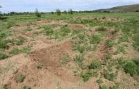
The most striking monument not only in the Dzhungar region, but in the entire northeastern Semirechye is the largest settlement, which is located on the eastern outskirts of the modern village of Antonovka, which has now been renamed Koilyk.
Part of its area has already been built up with modern houses and occupied by gardens and vegetable gardens. However, the territory of the medieval settlement is very well defined by the quadrangle of walls. From the mountains approaching the village from the south, the panorama of the settlement is clearly visible.
The yellow square of the walls stands out clearly against the greenery of the gardens. In the middle of the north-eastern wall there is one of the entrances, and near it, from the inside, a flat rectangular mound rises against the wall.
In the eastern part of the settlement there are many hills, in the location of which a certain system can be traced. These are the town estates. The surface of the settlement is literally “strewn” with fragments of pottery, jelly slag, and burnt bricks.
There are many fragments of vessels covered with a bright shiny glaze. All this prompted archaeologists to conduct excavations at the site, which made it possible to establish the beginning of the life of the city. The city arose in the VIIIth century. A characteristic set of finds dates back to this time.
Original belt pendants with a heart-shaped slot and S-shaped cheekpieces for bits were made in the 8th - 10th centuries. The same time dates back to clay red engobed jugs, decorated with stamp impressions in the form of a “lattice in a circle” and “wheels with spokes,” jugs with molded balls on the handles, and bowls.
An excavation at the top of the “citadel” revealed the remains of a building from the XIIth – early XIIIth centuries. A crushed cauldron and jug on the floor, a garbage pit - badrab, filled with household waste mixed with ash, the remains of a town house.
Archaeological research of the settlement began in 1964, when, under the leadership of K.M. Baipakov, then a number of pits were laid here and the plan of the settlement was taken, after which scientific work was not carried out here for many years.
They were resumed only in 1998 as part of the South Kazakhstan Complex Archaeological Expedition, during which an object identified as a “Buddhist temple” was excavated, and a residential estate on the citadel of the settlement was also explored.
In 1999 - 2000 Work was carried out on the so-called “rich man’s estate”, located in the south-eastern part of the settlement. In 2001, a hammam-type bathhouse made of baked brick was opened, and a mausoleum erected on the territory of the settlement during the period of abandonment was also examined.
In 2002 - 2003 The work focused on the study of stratigraphy, the creation of a digital three-dimensional topographical basis of the monument, as well as conservation and monitoring activities carried out at the “Buddhist temple”.
The field seasons of 2004 and 2005 were marked by the opening of a pillar-type Friday mosque, a “Manichean” temple, mausoleums, the facades of which were decorated with magnificent carved terracotta, as well as a khanqah located near the mausoleums.
The complex of buildings, of a public nature, provided unique material during the research of 2006 - 2007. Open monuments make it possible to begin powerful archaeological and museological research. The research carried out made it possible to describe the ancient monument as a city with a tripartite structure characteristic of most medieval monuments in Kazakhstan.
The site's plan has the shape of an irregular quadrangle, oriented with its corners to the cardinal points, surrounded by walls. The northeastern wall has a length of about 1200 meters, the southwestern one is 750 meters, and on its southwestern side the settlement is closely adjacent to the mountains.
Approximately every 30 - 45 meters on the wall there are towers with a round shape in plan. Not far from the western corner, there is a mound, square in shape, measuring 70 x 80 meters and 4.5 meters high. Entrances were located in the northwestern, northeastern and southeastern sides.
Inside, the entire vast territory of the fort is covered with numerous mounds and depressions - traces of former buildings. Clay walls, built using the method of strip filling, floated to a width of 11 - 13 meters, with a preserved height of up to 2 - 2.5 meters, border the quadrangular buildings of Shakhristan and, apparently, parts of Rabad, with a total area of 90 hectares.
The city occupied a vast territory, had fortress walls, a unique layout and even a heating system for residential premises. It had Buddhist temples, Muslim mosques and, judging by Rubruk's description, Christian churches.
It was established that the city’s territory was protected from enemy attacks by a 4-meter fortress wall adjacent to the foot of the mountains. Based on archaeological data, it can be assumed that Koylyk (otherwise known as Kayalyk) was an important political, economic and cultural center of the Karluks on the Great Silk Road.
In 2013, the Ministry of Culture and Information of the Republic of Kazakhstan included the Koylyk Settlement among the candidates for inclusion in the list of historical and cultural monuments of the UNESCO World Heritage Site.
Medieval estates of the XIIIth – XIVth centuries. Southern part of Kayalyk settlement.
“Rich estates” of the townspeople of the XIIIth century, heated by a system of chimneys and a bathhouse, were also discovered at the settlement. Estates are a one-time structure with thick external walls and a complex of internal premises.
Up to 15 rooms are allocated. The exposed building structures of the house are attributed to the late residential development of the XIIIth century. A complex heating system was detected. In all likelihood, warm air came from several local small-sized ovens and tandoors located in different parts and was distributed through distribution ducts - ducts.
Kanas are located along the walls and suf. They are interconnected and intersect at right angles. A large number of imported products were discovered.
Buddhist temple XIII – XIV centuries. at Kayalyk settlement. Northwestern part of settlement.
Bath-hammam XIII – XIV centuries. at Kayalyk settlement. Southern part of settlement.
Structurally, the bathhouse is a rectangular structure, measuring 11.36 × 8.9 meters, consisting of eight internal rooms located around the central hall, as well as a vestibule-shaped entrance located in the eastern part.
Four rooms are connected by wide passages to the central hall, thus forming a cruciform layout. Three rooms are connected to the central hall by narrow passages cut into its corners. The northern outer part of the structure, “L”-shaped, bounded on the southern and western sides by the walls of the building, was apparently occupied by an ivan.
Zhuma mosque XIII – XIV centuries. at Kayalyk settlement. Southern part of settlement.
The mosque is a quadrangular structure with dimensions of 32.6 × 26.7 meters along its internal contours, elongated from southwest to northeast. The entrance, 190 cm wide, is located in the center of the northwestern wall, on the opposite side there is a mihrab.
The interior space is divided by eight rows of 52 stone column bases forming nine naves. The pitch of the columns (the distance between the axes of the bases of the columns) is 3.5 - 3.7 meters. The bases of the columns are made of medium-sized pebbles and are buried 10–15 cm in relation to the floor level.
A number of fragments of burnt bricks serving decorative functions were placed on a pebble base.
Mausoleums of XII – XIV centuries. at Kayalyk settlement. Western part of settlement.
Kayalyk mausoleums belong to domed mausoleums with a dedicated main facade (according to the definition of L. Mankovskaya and S. Khmelnitsky, “facade” mausoleums). Facade mausoleums are buildings with a main entrance facade designed like a portal, more richly decorated than other facades and sometimes rising above them like a peshtak portal.
These mausoleums are designed to be approached from one main side. The construction of rich mausoleums in the traditions of Muslim mosque architecture is clear evidence of a situation in which Islam failed to eradicate any customs or laws and therefore an attempt was made to give them an Islamic coloring, to sanctify them with the laws of Islam.
The size of the internal space of the western mausoleum is 9.3 × 8.9 meters. The façade probably had the shape of an arched niche in a rectangular frame. The portal of the western mausoleum was wider than the southern facade.
Faceted three-quarter columns have been preserved on both sides of the portal. The eastern mausoleum was attached to the western one, and the eastern wall of the western mausoleum became common, uniting these two structures.
The portal of the eastern mausoleum recedes 3.7 meters in the northern direction, while the internal space of the eastern mausoleum is 5.8 x 5.8 meters. This deepening of the facade clearly emphasizes its subordination to the western mausoleum. Structurally, the portal of the mausoleum is identical to the portal of the western mausoleum.
Khanaka XII – XIV centuries. at Kayalyk settlement. Western part of settlement.
All that remains of the structure are the bases of the walls with a fixed row of baked bricks (27 × 27 × 4 cm), already known from the excavations of the Buddhist temple of Kayalyk. The western part of the structure was destroyed by a country road and an irrigation canal.
Research has established the presence of eleven rooms. The total size of the structure is 19.7 × 19.7 – 25 × 26 meters. The eastern half of the structure, well preserved in plan, as well as two rooms in the western part, provide grounds for a graphic reconstruction of the main volume.
The building had a centric organization of the internal space, where the central cross-shaped hall was crowned on four sides by open rooms (5 × 6 meters). In the four corners of the rectangle of the internal space of the structure, three rooms were located: a square corner one (5 × 5.5 meters) and two rectangular ones (3.5 × 5.5 meters), adjacent to the square one on both sides.
The courtyard was covered with a roof, as evidenced by four massive, cubic stones - the base of the columns on which the ceiling was supported.
Manichaean temple XIII – XIV centuries. at Kayalyk settlement. Western part of settlement.
The dimensions of the structure are 15 × 11 meters, the central hall is 11.2 × 8.4 meters. Thick adobe walls, which were plastered and whitewashed, have been preserved to a height of 60 - 70 cm. The rectangular room with its long side is oriented along the east-west line.
The entrance to the room is located in the center of the eastern wall, it is a passage 0.9 m wide. In front of the entrance to the hall there is a wide external extension of the ivan type (as evidenced by the layout of large stones, the upper level of which coincides with the cleared floor level).
Sogdian quarter XIII – XIV centuries. at Kayalyk settlement. Western part of settlement.
Excavations on the territory of the quadrangular plan of the hillock at the north-eastern entrance revealed a group of rooms that form the houses of the quarter. As a result of the excavations, a residential building made of mud brick measuring 37–38 × 21–22 × 6–7 cm, built without a foundation on a leveled mound, was discovered.
The building measured 12 × 16 meters and included seven rooms. These were residential and outbuildings. The walls were plastered with clay and adobe and whitewashed with lime. The house had a heating system in the form of underground channels laid along the walls and souf.
The main entrance was located on the eastern side and was marked by an ivan. From the ivan one entered the central room, which united other rooms around itself - two residential ones in the south and two utility rooms in the northern part; in the western one there was one isolated room. The house was destroyed suddenly by fire.
In the northern second utility room, a female skeleton was found on the floor. All household items remained in their places. On the souf in the central room there was a cauldron of pea porridge. The baby's cradle was located near the entrance to the southern half, and only a potty remained from it.
The front door lay at the entrance inside the room. All of her accessories were found: a chain, a ring, a hook and loop, and even a lock. Based on the ceramic material collected in the house, we can say that the tragedy occurred in the XIIIth century.
Below, in the second construction horizon, a house was exposed. Its layout and purpose of the premises is as follows. It was built of mud brick measuring 40 – 42 × 21 – 22 × 9 – 10 cm, its walls were reinforced with a wooden frame made of beams.
The walls were covered with thick clay plaster, then alabaster plaster and whitewashed with red chalk whitewash. Thirteen rooms were recorded, grouped around one central one. The ceramics complex is represented by unglazed forms of tableware. In terms of technical skill, they find analogies among the forms of Sogdian dishes of the VIIIth - XIth centuries.
On one of the vessels a monogram with pseudo-inscriptions was scratched into the damp clay. It is inscribed in a square divided into four sectors diagonally.
Caravanserai X – XII centuries. at Kayalyk settlement. Western part of settlement.
The building is subquadrangular in plan, 30 × 30 meters. Archaeological research was carried out on the eastern side of the structure.
Mausoleums of the XVIIIth – XIXth centuries. Southern part of settlement.
Several mausoleums of ethnographic time in the topography of the settlement are readable in the form of sub-square mounds. Two of them have been excavated. The fortress wall at the Kayalyk settlement. It surrounds the ancient settlement and is preserved in separate fragments (segments).
Particularly expressive are two sections, located one on the left and the other on the right side of the Ashchi-Bulak River. The so-called right-bank fragment of the wall in the upper part is built up with houses and in one place was partially cut off for the construction of a hayloft - a clear ribbon system of plow filling can be read in the cut, and the height of the wall is more than 2.5 meters.
On the upper platform of the left bank fragment, a concrete frame of the store was erected in the 70s. The height of the wall in this part is about two meters. The third fragment, the best preserved, is located near the southern corner of Shakhristan; the height of the wall in this place ranges from 2 to 2.4 meters, with a width of 12 – 13 meters.
The outer defensive ditch, easily visible from the southwestern side of the wall, is full of water even in summer.
Geographic coordinates of Kayalyk settlement (Antonovskoye): N45°39'50.45" E80°15'36.80"
Note:
If you are using geographic coordinates for Google Earth or Google Maps navigation systems, you must remove the last two digits from geographic coordinates and " (hundredths of a second) and enter the result in the input line. Example: N51°44'09.67" E72°39'40.81" = N51°44'09 E72°39'40
Authority:
https://www.archeology.kz/ru/453-muzejefikacija.html
Photos by:
Alexander Petrov.