Вы здесь
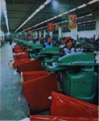
Alma-Ata knitting factory.

Excursions and tours around Almaty.
“If you have hands, you will find a shovel, and that means you will have money.”
Turkmen proverb.
Almaty manufacturing enterprises.
Alma-Ata knitting factory, a production association, of Ministry of Light Industry of Kazakh SSR was located on M. Mametova Street, 67, between Seifullin and Dzerzhinsky (now Nauryzbay Batyr) streets in Sovetsky district (now Almalinsky).
The company was created in 1975 on the basis of the knitwear company of the same name. The Alma-Ata knitting factory was organized on the basis of the Ivanteevsky knitting factory evacuated to Alma-Ata during the Great Patriotic War.
The divisions include the parent company, branches No. 1 in Almaty, No. 2 in the city of Talgar and No. 3 in the city of Tekeli.
During the Great Patriotic War it produced military uniforms. In Soviet times, it produced outer and underwear knitwear for adults and children (94 types of products). In Soviet times, the Alma-Ata Knitting Factory named after Dzerzhinsky was famous throughout the republic for its range of products for children and adults.
In 1982, goods worth 60,304 rubles were sold. The introduction of new technology and rationalization proposals during the 10th Five-Year Plan provided savings of about 4.3 million rubles. The capital-labor ratio increased during this period by 50.8%, the electrical supply by 12.6%, and labor productivity by 17.7%.
In 1982, 27.2% of the total volume of products were produced with the State Quality Mark. In 1969, Czechoslovakian equipment was installed at the Alma-Ata knitting factory named after F. Dzerzhinsky. In the 90s of the last century, the factory was privatized, removed from state ownership, then transformed into a joint-stock company and liquidated, and its workshops and other facilities were sold.
Now the building houses company offices, cafes, shops, gyms, beauty salons, etc.
Geographic coordinates of Almaty knitting factory: N43°16'01 E76°55'57
Note:
If you are using geographic coordinates for Google Earth or Google Maps navigation systems, you must remove the last two digits from geographic coordinates and " (hundredths of a second) and enter the result in the input line. Example: N51°44'09.67" E72°39'40.81" = N51°44'09 E72°39'40
Authority and photos by:
https://ru.wikipedia.org/wiki/%D0%90%D0%BB%D0%BC%D0%B0-


