


![]()
Вы здесь
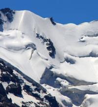
Walter Glacier in Pamirs.
Expedition tours in Pamir mountains.
“Walter and I had a great honor. Nikolai Vasilyevich named 2 glaciers descending from Stalin Peak after our names! The northwestern one, between Stalin and Moskvin Peak, is mine, the “Traube Glacier”. And the north-eastern one, between Stalin Peak and Vorobyov Peak, is the “Walter Glacier”. For me this is a great joy and quite undeserved. Still, although the glaciers are small, they descend from the greatest peak of the USSR at 7495 meters! Last year we were the first to attend them, each in his own way. Yes, I never dreamed of getting into geography. These glaciers flow into the A.V. glacier. Moskvina. Very steep and almost impassable due to the seracs and icefalls.”
From the diaries of Peter Traube. 1933.
Glaciers on northern slope of Pamir firn plateau.
Upper limit of Walter glacier is located at an altitude of: 6685 meters (Khokhlova peak) above sea level, 6841 meters (Izvestia peak) above sea level, 6641 meters (Clara Zetkin peak) above sea level, end of glacier is located at an altitude of 3889 meters above sea level, is located on the northeastern slope of the Pamir firn plateau, on northern slope of Peter Great ridge, in Lakhsh region of Republic of Tajikistan.
The sources of the Walter Glacier lie between Vorobyov Peak and part of the Academy of Sciences ridge from Clara Zetkin Peak to a peak 6701 meters above sea level. Next, the glacier turns north, receiving small landslide ice along the way from the edge of the Pamir firn plateau and its wall.
The Walter Glacier originates from the northeastern slopes of the Pamir firn plateau, located in turn on the northern slopes of the Peter the Great ridge. After the “Borodkin Rib”, a large tributary is added to the Walter glacier, formed by the ice of the northeastern slopes of Kirov Peak.
This tributary was named the Traube glacier in 1933 (in the “Catalog of Glaciers of the USSR”, it is not distinguished as an independent one). The length of the Walter Glacier is 13.4 kilometers, its area reaches 17.21 square kilometers, and the perimeter of the glacier is 29.16 kilometers.
A 2.1-kilometer-long river flows from the glacier, which, merging with tributaries from the Moskvin and Traube glaciers, belongs to the Fortambek glacier basin. At an altitude of 4456 meters above sea level, the Walter Glacier merges with the Traube Glacier. 630 meters east of the confluence of the Moskvina and Walter and Traube glaciers, from July to the end of August there is a mountaineering camp in the Moskvina glade (Suloev glade).
Geographic coordinates of Walter Glacier: N38°59'06 E72°00'55
Authority:
Alexander Petrov.
"Fortambek and its peaks." G. Kalinin. Tashkent, Uzbekistan, 1983.
Photos by:
Alexander Petrov.