


![]()
Вы здесь
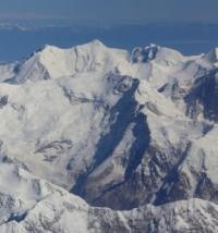
Ailanysh Yuzhny Glacier.
Glaciers in upper reaches of Jety-Oguz Gorge.
“Turning around in a situation where there seems to be nothing particularly dangerous is sometimes a heroic act. Such feats are only for you. Do them. Turn back, but get the opportunity to come back here again. No mountain is worth a single nail on your little finger!”
Nikolay Totmyanin.
Walk to Ailanysh Yuzhny Glacier from Jety-Oguz Gorge.
Upper boundary of Ailanysh Yuzhny Glacier is located at an altitude of 4,323 meters above sea level, end of glacier is at an altitude of 3,444 meters above sea level, located in upper reaches of Ailanysh Gorge, on northern slope of Terskey Ala-Too Range in Jety-Oguz District of Issyk-Kul Region.
The glacier gives rise to the Ailanysh River, 9 kilometers long, which is a right tributary of the Jety-Oguz River. The area of the glacier is 2.22 square kilometers, the perimeter of the glacier reaches 8.09 kilometers. The length of the glacier is 2.7 kilometers.
The end of the glacier is located at an altitude of 3444 meters above sea level. The ridge of the Jety-Oguz and Karakol spur, stretching from the southeast to the northwest with a length of 900 meters, separates the Ailanysh South glacier from the Uyuktor East glacier with a length of 4 kilometers belonging to the Karakol River basin.
The latitudinal ridge separates the Ailanysh South glacier from the Ailanysh North glacier.
Geographic coordinates of Ailanysh South glacier: N42 ° 10'54 E78 ° 25'44
Authority and photos by:
Alexander Petrov.