


![]()
Вы здесь
Kent Mountain Forest.


Tours in Kent Mountains.
"In the Kent Volost, 50 miles from the Kyzyl-Kench tract, the remains of a fortress remain, known to the Kyrgyz as 'Ture-Kashkan,' meaning 'the chief has fled.' A huge hollow stone with an artificial filling remains from this fortress dating back to the sixth century. Fired brick tiles with inscriptions have also been found there many times."
N. Ya. Konshin. "From Pavlodar to Karkaralinsk." 1901.
Travel in Kent Mountains.
Kent mountain forest ranges from 965 meters above sea level (located in western part of mountains, in Ortashokay valley) to 1,469 meters (Mount Tursen) in southeastern part of range, 24 kilometers east of Karkaraly mountain range, part of Karkaraly Nature Park in district of same name in eastern Karaganda region.
Kent Mountains are one of the unique natural and historical regions of Saryarka, a Kazakh upland area. They are located east of the Karkaraly range. They extend 47 kilometers from southwest to northeast, reaching their greatest width in the central part, reaching 31 kilometers.
To the north, the mountains are bounded by the Sarybulak River valley and the Burkutty Mountains. To the east, the mountains are further bounded by the south-extending Sarybulak Valley, which merges with the Muzdybay River valley. To the south, the Kent Mountains are backed by the Korgantas and Koyandybulak massifs and the valleys of the Akkiyak and Uzen rivers.
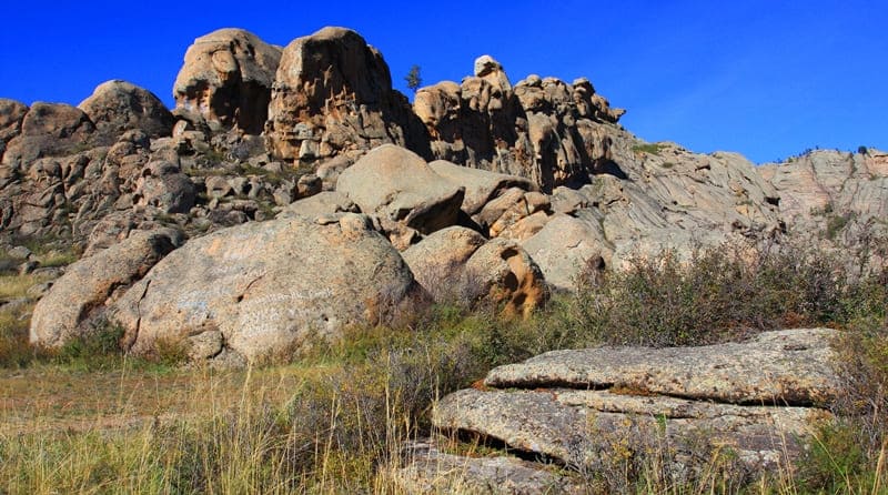
To the west, the two Kent and Karkaraly mountain ranges are separated by the wide valley of the Taldy River. These cliffs have stood here for millennia. The indomitable steppe wind, like a patient sculptor, sculpted scenes known only to it. Year after year, century after century, the wind carved out grottoes, caves, and crevices.
The wind has shaped the Kent Mountains into bizarre shapes you won't see anywhere else. The highest point of the Kent Mountains is Mount Tursen, 1,469 meters above sea level, an island massif that rises like an impenetrable granite wall above the surrounding steppe in the southeastern part.
The next highest point is considered to be two mountains of equal height – Kent in the south and Zhamantau in the north, both 1,398 meters above sea level. Numerous mountain rivers and streams flow down the mountains. Their valleys lead into the interior of a vast granite island, where the traveler is treated to majestic scenes of pristine nature, with boulders, ridges, rubble, and the most bizarre sculptures of eroding granite and granitoids.
The Sarybulak, Muzdybay, Akkiyak, Uzen, Karagash, Kadyr, Bakbay, Kyzylkennysh, and Kyzylashchi rivers flow through the gorges, offering a rich variety of hydrographic features. Amazing stone sculptures adorn the granite bastions of Kent, including the Aulietas (Holy Stone) valley, 1,194 meters above sea level, revered by the Kazakhs, who come to it for ritual ceremonies.
The summit of Aulietas is flat, and dozens of small lakes with bitter, reddish water are nestled in the granite. The flat tops of the granite ridges are dotted with dozens of lake basins, which serve as watering holes for the remaining argali sheep.
History of exploration and first mentions of Kent Mountains.
The Kent Mountains are a relatively young mountain range. During the Paleozoic era, 250 - 300 million years ago, a sea foamed in the place where the mountains now are, accumulating solid sediments, limestone, crystalline schists, and quartzites at the bottom.
The waters receded only 1.2 - 2 million years ago, when the ancient Paleozoic shield was breached by granite. This resulted in the block uplift of the areas that became the Kent Mountains. The first information about the Kent Mountains appeared in the XVIIIth century, when Russian military expeditions and explorers passed through these areas.
In their records, they noted the unusual combination of forested areas and rocky mountains amidst the vast steppe. A.I. Levshin (1797 - 1879), one of the founders of the Imperial Russian Geographical Society, was called "the Herodotus of the Kazakh people" by Kazakhstan's first geographer, Shokan Valikhanov. (Levshin, A.I., Description of the Kirghiz-Cossack or Kirghiz-Kaisak Hordes and Steppes, St. Petersburg, 1832, in 3 volumes).
Later, geologists and ethnographers worked here, documenting the rich flora, the presence of rare granite rocks, and traces of ancient settlements. Archaeological excavations in the XXth century confirmed that the Kent Mountains have long been a habitat for people.
Saka-era burial mounds, remains of ancient mines, and settlements have been found here. The massif's uniqueness allows it to be considered not only a natural but also a historical and cultural monument.
Archaeology of Kent Mountains.
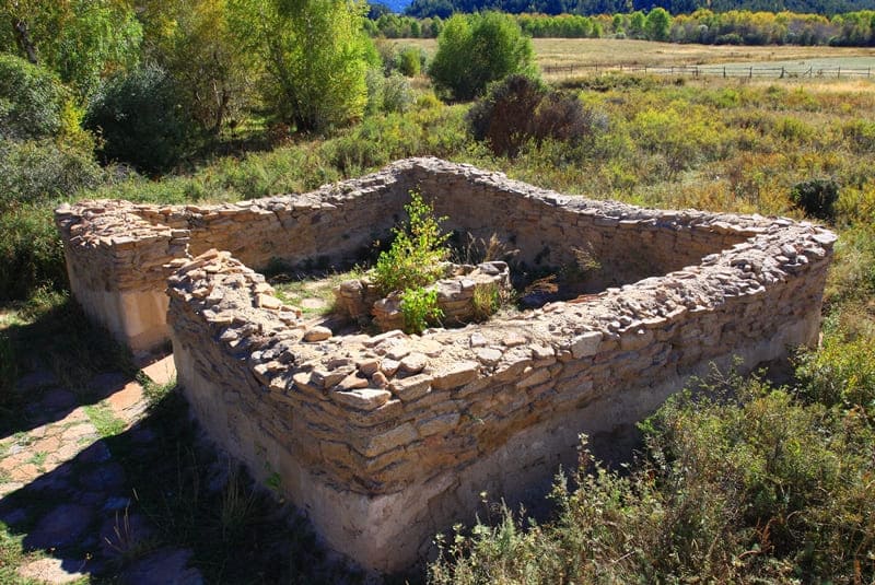
The Kent Mountains have attracted people since ancient times, as evidenced by numerous archaeological sites. Paleolithic tools, Mesolithic and Neolithic sites, and Bronze Age settlements and burial grounds have been found here. Numerous stone mounds date back to the Early Iron Age in the Kent Mountains.
The medieval era is represented by burial mounds and enclosures with stone sculptures. The famous Kyzylkent Palace dates back to the late Middle Ages. In one of the spacious gorges of Kzylkenesh lie the ruins of the legendary Kyzylkent Palace, or more precisely, a XVIIth-century Buddhist temple built by the Dzungars during their rule in Saryarka.
The burials are typical of the Great Steppe – low mounds with stone enclosures. Sometimes these mounds are 30-40 meters in diameter, and the enclosures are made of menhirs, but here the mounds are small. Nearby is the Damalaktas sanctuary, a pre-Islamic temple, the Bronze Age settlement of Kent, and Alat, burial ground Tasyrbay.
Legend of Kent Mountains.
According to legend, a large settlement once stood in these parts – Kent. Its inhabitants were renowned for their industriousness and friendship. But one day, a nomadic army attacked the region. To protect his people, an old shaman appealed to the mountain spirits.
They heard his prayers and raised stone walls, protecting the settlement from enemies. Thus, the mountain range was born, and its name preserved the memory of that very settlement – Kent. Locals still believe that if you climb Mount Tursen and make a wish concerning your family and home, the mountain spirits will surely hear you and help you.
Nature and Features of Kent Mountain Range.
Kent Mountains are an isolated granite massif surrounded by steppes. Their natural features make the range a unique "oasis" amidst the Kazakh plains.
Terrain: Rocky ridges alternate with forest clearings, gorges, and picturesque gorges.
Flora: Pine and birch forests grow on the slopes, and rare plant species listed in the Red Book are found.
Fauna: Roe deer, foxes, and hares inhabit this area, while eagles and golden eagles soar in the sky.
Climate: Milder than the steppe, thanks to the forests and rock formations, which retain moisture.
Travel information for visiting Kent Mountains.
Today, the Kent Mountains are a popular destination for ecotourism and ethnographic routes.
How to get there:
From the town of Karkaraly, it's about 24 km along a scenic road. You can get there by car or with a tour group.
Best time to visit: May - September, when the forests are especially green and hiking and picnicking are possible.
What to see: Ortashokai ravine, Mount Tursen (1,469 meters above sea level), picturesque gorges and rock outcrops, ancient burial mounds, and traces of ancient mines.
Tips for visiting Kent Mountains.
Bring comfortable shoes and plenty of water;
Overnight camping is possible, but it's best to coordinate your route with the national park administration;
For history buffs, there are excursions to archaeological sites.
Significance of Kent Mountains.
Kent mountain forest is not only a natural gem of the Karaganda region but also a place where nature is closely intertwined with history and legend. It attracts tourists with its beauty, archaeologists with its rich past, and locals with its symbol of strength and protection.
Geographical coordinates of Kent Mountains are: N49°10'48 E75°54'22


Authority photos by:
Alexander Petrov.