


![]()
You are here
Geology and relief of Kazakh small hills.
Educational tours around Kazakh hills.
“Geologically, the territory of the K. m. is part of the Ural-Mongolian geosynclinal belt. It is composed of highly dislocated metamorphic shales, quartzites, sandstones and limestones of the Paleozoic, in places covered by Meso-Cenozoic sediments; up to 60% of the area is occupied by intrusive (granites, diorites, porphyrites) and effusive rocks.”
N. A. Gvozdetsky.
Natural parks in Kazakh hills.
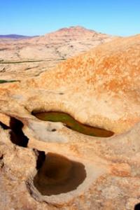
Kazakh folded country is characterized by a general elevation of the territory with an altitude range from 200 to 1500 m. a. s. l., the predominant part of the surface lies at altitudes of 400-1000 m. a. s. l., the second feature is monolithicity, relatively weak development of large internal depressions.
In this regard, there are significant differences between the western and eastern parts of the country. In the western part, two high-mountain massifs stand out - the Kokchetav Upland (947 m. a. s. l.) and Ulytau (1133 m. a. s. l.), separated by the vast Tengiz-Kurgaldzhin depression with a flat, flat topography.
The Sarysu-Tengiz watershed separates it from the Dzhezkazgan depression. In general, the western part of the country is predominantly an elevated plain with an average altitude of 300-500 m. a. s. l. n the eastern part of the Kazakh folded country, such differentiation between uplands and depressions is not observed.
In general, the surface here is distinguished by high altitudes (500-1000 m. a. s. l.) and a more dissected relief; it has the form of an arched rise, in the center of which are the Kyzyltas Mountains with the highest point of the Kazakh small hills - Mount Aksoran (1565 m. a. s. l.), the Kent Mountains (1469 m. a. s. l.), the Karkaraly Mountains (1403 m. a. s. l.), and-hers.
To the east, towards Tarbagatai, the Chingiztau ridge stretches (1305 m. a. s. l.). The mountain ranges are surrounded by a strip of small hills, passing along the outskirts into elevated undulating plains. The relief features of the territory are determined by the history of formation and geological structure.
The Kazakh folded country represents the Kazakh shield of the young Epipaleozoic Ural-Siberian platform. The geological structure of the shield is quite complex. Remains of Proterozoic structures are preserved here, and Caledonian and Hercynian structures are numerous.
Folded structures of the Kazakh shield of different ages and even of the same age are oriented in different directions. This, in combination with the more ancient massifs present here, creates a general mosaic structure of the territory. During the Archean and Early Proterozoic, a folded foundation of deeply metamorphosed rocks was formed on the territory of the Kazakh hillocks: gneisses, crystalline schists, marbles, amphibolites, granitoids.
On its eroded surface, starting from the Upper Proterozoic, sedimentary and sedimentary-volcanogenic strata close to platform ones accumulated. Consequently, at the end of the Proterozoic there existed an ancient platform with a two-tier structure (protoplatform).
The rocks that formed it reach the ancient surface in the Kokchetav massif and the core of the Ulytau anticlinorium. The protoplatform was broken by a series of faults of different ages. In the near-fault zones, tectonic movements were activated: subsidence, accumulation of sedimentary and sedimentary-volcanogenic strata, folding.
This is how the folded structures of the upper tier were formed. In the western part of the Kazakh hillocks, these structures were created by Salair and Early Caledonian folding. Already in the Devonian, the formation of two large superimposed depressions began here - Dzhezkazgan and Tengiz.
In the depressions and upper Paleozoic, carbonate, coal-bearing and salt-bearing sediments accumulated, i.e. the formation of a sedimentary cover began. The structures of the eastern part of the Kazakh small hills are created mainly by Hercynian folding. Only in the Chiegiz-Tarbagatai anticlinorium did the Late Caledonian folding appear.
To the southwest of it is the Dzungarian-Balkhash zone of the Early Hercynian consolidation, and to the north-east is the Irtysh-Zaisan Late Hercynian folded zone. During the Caledonian and Hercynian cycles, intense magmatic activity occurred in the area.
It is associated with an abundance of volcanic deposits and intrusions of various compositions with a sharp predominance of acidic ones, as well as the metamorphization of Paleozoic deposits and a wealth of various ore minerals. Folding was accompanied by the formation of faults, thrusts, normal faults and reverse faults.
Based on satellite imagery, a lot of linear and ring structures have been identified on the territory of the Kazakh folded country. Linear structures correspond to faults of various scales. Some of them, obviously. Corresponds to a system of arc faults, others emphasize the isometric shape of various geological objects: destroyed ancient volcanoes, depressions, etc.
In the Proterozoic and early Paleozoic, part of the vast Ural-Tian-Shan geosynclinal region was located on the territory of the Kazakh small hills. At the end of the Lower Paleozoic, as a result of the manifestation of the Caledonian folding in the west of the territory of the Kazakh small hills, a rigid folded block was formed, while in its eastern part the geosynclinal regime was preserved.
Only towards the end of the Paleozoic, as a result of the Hercynian orogeny, the eastern part also turned into a folded mountain range. Since that time, the entire Kazakh small hills acquired a platform regime and entered the continental period of development.
Both Caledonian and Hercynian folding were accompanied by the formation of concepts, depressions, bends, faults, along which thrusts and reverse faults occurred. At the same time, volcanic activity developed, causing strong metamorphism of Paleozoic deposits.
In the post-Hercynian time, the Kazakh small hills entered the platform stage of development, during which it maintained a steady tendency to rise. Throughout the Mesozoic and Paleogene, the territory of the shield remained elevated land and retained a continental development regime, under the conditions of which the formation of denudation relief took place.
The humid, warm climate contributed to a significant intensity of denudation processes. The area became a peneplain with residual hills. A thick weathering crust was formed. Continental river and lake-swamp, and in places coal-bearing sediments accumulated in relief depressions.
In the Paleogene, during the period of maximum marine transgression, the margins of the shield and the depressions open to the marginal parts (Tengiz and Dzhezkazgan) were briefly filled with sea waters. n Neogene-Quaternary time, an uplift of the territory occurred, but its amplitude was different in different places.
The abrasion plains of the Paleogene sea along the
There were uplifts and relative subsidences of certain parts of the territory, which led to a rejuvenation of the relief in the most elevated areas. The result of neotectonic movements was the emergence of island mountains. In the western part of the shield, movements were of an inherited nature, so ancient tectonic structures are quite clearly expressed in the relief.
In depressions that lagged behind in uplift, the leveling surface was covered by continental Neogene-Quaternary sediments. In the eastern part of the Kazakh folded country, which is directly adjacent to areas of active mountain building, along with inherited structures (Chingiztau), superimposed structures (Karkaraly, Bayanaul uplifts, Balkhash-Alakol depression, etc.) are also common.
Thus, the main features of the modern relief of the Kazakh folded country were created as a result of long-term peneplization and recent tectonic movements, which were caused by the emergence of large unevenness of the relief and led to an increase in its dissection.
The main types of morphostructures are basement denudation plains, small hills and denudation-tectonic lowlands and hills forming several main geomorphological levels. The lowlands cannot be regarded simply as a denuded mountainous country. They correspond to areas of vast recent uplifts - formed by neotectonics slopes.
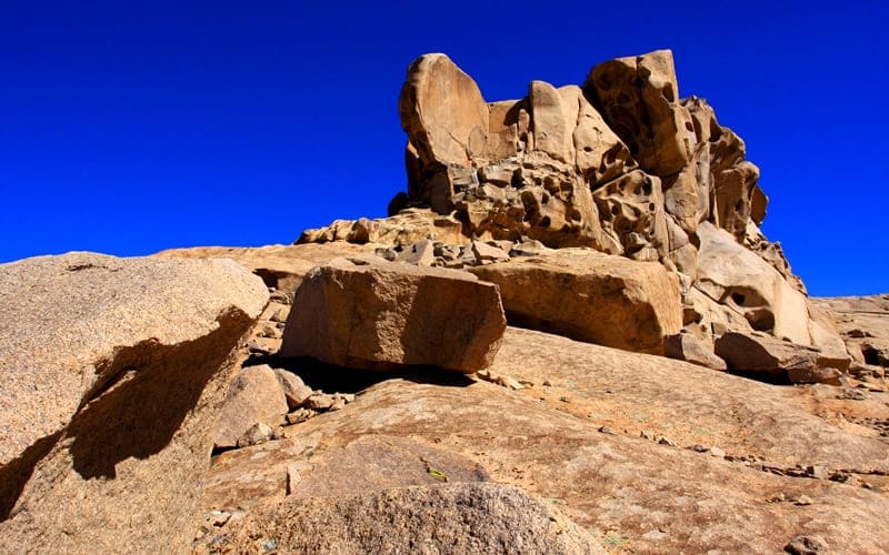
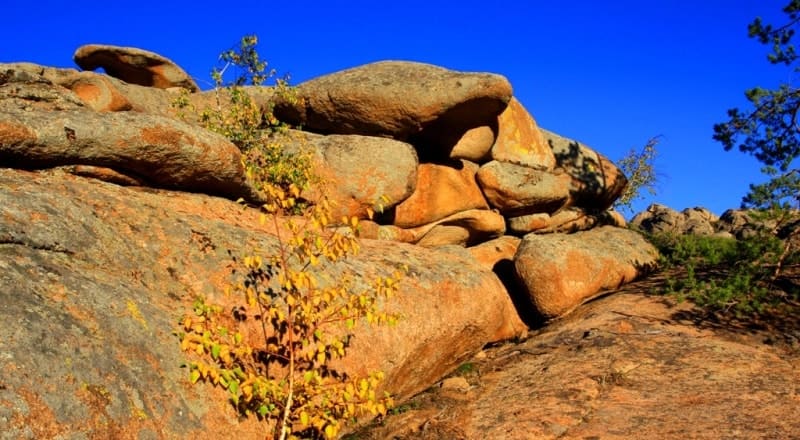
Quartzites define the sharp rocky forms of the hills. In the area of development, Paleozoic rocks (sandstones, shales, limestones) are dislocated; hilly-ridge small hills predominate. The chains of hills and depressions between them are oriented along the strike of the folds.
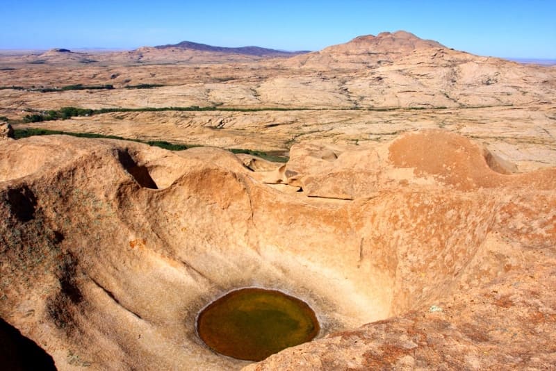
In areas of granite intrusions, the hills are complicated by rounded blocks and protrusions. Based on their hypsometric position and origin, several types of small hills are distinguished. First of all, a distinction is made between watershed and riverine small hills.
The watershed small hills usually occupy a higher hypsometric position than the basement plains (500-650 meters). The riverine small hills are a densely but shallowly rugged relief formed by a cluster of low hills of similar height. sually it lies below the denudation interfluves, due to the dismemberment of the marginal part of which it was formed.
The highest hypsometric level is occupied by the tier of hills (500-700 meters), low mountains and middle mountains. It is confined to areas of extensive recent uplifts. Compared to small hills, this relief is distinguished by a greater depth of dissection; respectively, 100-200, 250-500 and 300-600 meters above sea level, the slopes have a steepness of 15-200, are often rocky, and are distinguished by an abundance of weakly turfed screes.
The apical surfaces are quite varied. Sometimes these are narrow rocky ridges (Kent, Chingiztau), but often rounded and dome-shaped peaks. In the area of the Karkaraly Mountains, almost flat surface peaks are clearly visible - the remains of an ancient peneplain.
Thanks to them, mountain uplifts take on the appearance of a plateau, separated by erosional incisions. The characteristic forms of relief of the Kazakh small hills are ancient and modern river valleys. The ancient valleys, only partially used by the modern river network, are especially striking for their significant size and wide distribution.
The bottoms of modern river valleys are represented by a floodplain and two terraces above the floodplain, forming the lowest hypsometric level, but only on the outskirts of the small hills does it drop slightly below 200 meters.
Authority:
N. A. Gvozdetsky, N. I. Mikhailov “Physical Geography of the USSR”, Asian part, Third edition, corrected and expanded, Moscow “Thought” 1978.
Photos by:
Alexander Petrov.