


![]()
Вы здесь
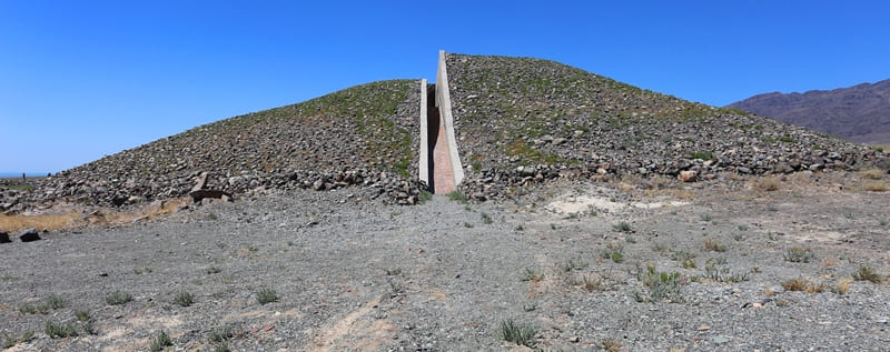
Third Besshatyr burial mound.

Excursion to Third Besshatyr burial mound.
"The discovery of settlements indicates that local tribes had permanent wintering sites and spent the cold season in warm dugout dwellings. It is quite likely that as early as the Saka and certainly during the Wusun period, a pastoral-nomadic system with alternating grazing of livestock on seasonal pastures developed in the Semirechye region."
K. A. Akishev, G. A. Kushabaev. "The Ancient Culture of the Sakas and Wusuns of the Ili River Valley." 1963.
Saka Culture of Ili River Valley.
Third Besshatyr burial mound is located at an altitude of 679 m. a. s. l.. m., is located in western part of Besshatyr burial ground, 4.4 kilometers from right bank of Ili River delta, 27.5 kilometers east and slightly north of Cordon No. 1, 50.8 kilometers southwest of village of Basshy, 3.5 kilometers southeast of beginning of Shylbyr Gorge, within Altyn-Emel Nature Park, in Kerbulak District of Zhetysu Region.
The third Besshatyr burial mound is located in the northwestern part of the burial ground and is the second largest mound after the Bolshoi Mound. The diameter from north to south is 73 m, from west to east - 75 m, and the height is 11.5 m. The top of the mound is flat (20 m in diameter), destroyed by a large 3 m deep looter's crater.
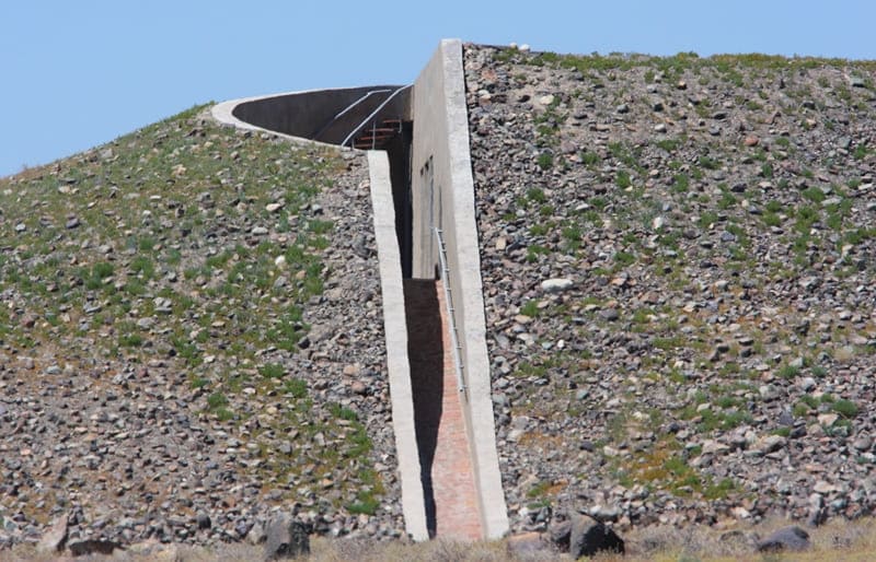
The base of the mound is lined with large broken stones, giving the impression that the mound rests on a foundation. On the southern side of the mound, there is a depression (3 m wide) descending from top to bottom and ending in a flat mound 12 m in diameter and up to 1 m high.
A similar depression is on the northwestern side. 4 m from the base of the mound runs a stone rampart 1.3-1.7 m wide. In some parts of the rampart, particularly the northern part, stonework remains, 50-60 cm high. The mound is surrounded by 40 fences composed of large boulders and menhirs.
The latter are always dug in from the inside (toward the mound). The fences are 50 meters from the rampart on the south, 17 meters on the north, 15 meters on the west, and 8 meters on the east. There is a 70-meter gap in the chain of fences on the western side, and a 55-meter gap on the northern side, resulting in only three fences on the northwestern side of the mound.
On the southeastern side of the mound, between the rampart and the chain of fences, are two separate fences. There are 42 of them in total. A drawing has been carved with a sharp tool on one of the boulders, part of the separate southern fence.
It depicts a mountain goat with large, curved horns, lying on its back. A wolf, with a long, drooping tail and erect ears, has clutched its throat. Excavations of the Third Kurgan were conducted in 1960. The mound's embankment was removed, three enclosures were excavated, and a 40-meter-long section of the stone rampart was cleared.
To determine its structure, the southern half of the mound was removed to its full height. The excavation revealed that the mound consists of 17 alternating layers of stone, earth, and rubble. In horizontal section, these layers appear as concentric rings 30-50 cm wide for the stone layers and 2 meters for the earth layers.
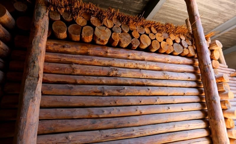
Inside the mound, in the center, was a mound of coarse rubble and stone, 4 meters high and 15 meters in diameter. As in other excavated Besshatyr kurgans, here, too, a log tomb once stood beneath the stone embankment. However, it was burned, likely to conceal the evidence of the looters' predatory excavations.
The mound contained underground passages dug into the bedrock. The entrance to the underground chamber began from a depression in the southern half of the embankment. The passages are up to 1.7 meters high and up to 1.3 meters wide.
Excavations of the stone rampart revealed that they are the remains of a collapsed stone wall erected around the embankment. The height of the wall's masonry after clearing is 70 cm. Judging by the number of stones that fell to the ground, the original height of the wall was 1-1.2 meters.
Geographical coordinates of third Besshatyr mound: N43°55'25 E78°12'27


Authority:
K. A. Akishev, G. A. Kushabaev.
"Ancient Culture of the Sakas and Wusuns of the Ili River Valley." Academy of Sciences of the Kazakh SSR. Ch. Ch. Valikhanov Institute of History, Archaeology, and Ethnography. Publishing house of the Academy of Sciences of the Kazakh SSR. Alma-Ata. 1963
Alexander Petrov.
Photos by:
Alexander Petrov.