


![]()
Вы здесь
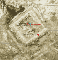
Aktam ancient settlement.
Ancient sites of ancient settlement in deserts of Kazakhstan.
"...Bakanas is recognized in Russian literature as the ancient bed of the Ili River. On maps and in literature, the area along Bakanas is depicted as solid sand, which is completely incorrect: the soil along Bakanas is loess, traces of ancient irrigation ditches are visible everywhere... 20-25 miles from Lake Balkhash are the ruins of Ak-tam (the Kazakhs extract burnt bricks there for their wintering), and various vessels were found."
Mukhamedzhan Tynyshpayev. 1926. Congress of the Society for the Study of Kazakhstan.
Travel across Almaty reion.
Aktam ancient settlement (translated from Kazakh Aktam - White Roof) is located at an altitude of 370 meters above sea level, located 84.7 kilometers southeast of the village of Karaoy, 44.6 kilometers southwest of the village of Bosingen, in 121.7 kilometers southwest of the village of Akzhar, in Balkhash district in Almaty region.
Aktam ancient settlement is located in the central part of the Saryesik-Atyrau sands, in the north-west of the Akdala valley. Aktam ancient settlement is located 81.3 kilometers to the south and a little east of the Karamergen settlement, from the Agashayak settlement - Aktam is 42.6 kilometers to the south and a little east.
The ancient settlement is located between the dry riverbeds Orta-Bakanas in the east and Shet-Bakanas in the east. Aktam ancient settlement is a square structure in plan, located from the southwest to the northeast on the cardinal points.
The length of the swollen fortification walls is: southern - 186, western - 184, eastern - 184, northern - 188 meters. The fortification area is 37410.63 square meters, the perimeter reaches 774.78 meters. Corner towers and entrances are quite well preserved on the settlement of Karamergen.
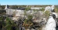
Aktam is the largest in terms of area among the settlements Agashayak and Karamergen located to the north. The ruins represent an elevated rectangular area surrounded by a sagging wall. All four corners are fortified with round towers protruding strongly outward, 10 - 12 meters in diameter and now retaining a height of up to 3 meters.
Long walls had 4 towers, 35 meters from one another, short ones - two towers each, covering the entrances to the town. Entrances are arranged in the form of L-shaped corridors. The inner part of the settlement is a flat area covered in places with takyrs and overgrown with saxaul.
On the western side of the settlement Aktam, one and a half kilometers from it, archaeologists discovered a main canal, withdrawn from the channel of Orta-Bakanas, 20 kilometers long. Even now, half covered with sand and overgrown with saxaul, it makes a strong impression. Its width is almost 5 meters, depth is 2 meters.
In the head part of the canal, the remains of an earthen dam about 20 meters long and up to 3 meters high have been preserved. Through this powerful structure, the water level in the Orta-Bakanas river was raised and its flow was ensured.
The canal was cleaned many times from silt sediments that clogged the path of water. Heaps of silt, dried into stones, now pile up on both banks of the dry channel. To some extent, the picture of maintaining the irrigation system in order can be recreated based on ethnographic observations of the late XIXth century.
True, these observations were made in another area, in the lower reaches of the Chu, but the closeness of the natural geographical conditions makes it possible to attribute them to the lower reaches of the Ili. “The Kazakhs who lived in the lower reaches of the Chu River,” reports the ethnographer L. Chormak, “were divided into several communities.
Each of them had its own main ditch - "togan", derived from the Chu River. Its length sometimes reached 25 kilometers, and the right to use water was conditional on participation in the work on conducting and maintaining the "togan" in order.
Such work was carried out by many people, so the entire population of the lower reaches of the Chu River divided the axis according to the number of main ditches into several communities living in their villages. Before the irrigation season, almost the entire population went out to clean the main canals.”
Hundreds of people in the lower reaches of the Ili River were once busy with irrigation work.
Geographical coordinates of Aktam settlement: N45°32'30 E75°46'32
Authority:
"Medieval cities of Kazakhstan on the Great Silk Road". K.M. Baipakov, Almaty, Gylym, 1998, 216 p.