


![]()
Вы здесь
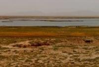
Chatyr-Kol lake.
High-mountain lakes Kyrgyz Tien-Shan.
“On the 18th (March 18, 1859, according to the old style, according to the new one - March 21), we reached a rather vast valley of the mountain lake Chadyrkul (Chatyr-Kul), surrounded on all sides by mountains and dressed in deep snow cover. Lake Chadyrkul is about 10 versts wide and about 20 long, it must have a high position, not less than 7000 feet of absolute height.»
Chokan Valikhanov.
Trip to Chatyr-Kol lake from Tahs-Rabat caravanserai.
Alpine lake Chatyr-Kol is located at an altitude of 3530.2 meters above sea level, located between the southwestern part of the Atbashi ridge and the northeastern part of the Torugart-Too ridge in the Atbashinsky district of the Naryn region.
The length of the lake from southwest to northeast is 22.5 kilometers, the largest width in the central part is 10.8 kilometers. The area of the water mirror is 160.1 square kilometers, the perimeter of the lake reaches 57.37 kilometers, the average volume of water is 8.5 cubic kilometers.
Lake Chatyr-Kol is located in the intermountain Chatyr-Kol lowland in the southwest of the sublatitudinal At-Bashi ridge and in the northeast of the Torugart-Too ridge. The length of the Torugart-Too ridge is 74 kilometers, the width is 14 kilometers, including the southern tip of the ridge located in the Republic of China.
The prevailing depths of the lake are 12 - 13 meters, in the western part up to 18 - 19 meters, in the eastern part - 8 meters. The bottom of the lake has a hilly-pit structure everywhere. 24 rivers, large and small, flow into the lake.
The largest of them are: Kekaygyr, 45 kilometers long, flowing into the lake from the east, Torugartsay, 13 kilometers long, flowing into the lake from the southeast, the Kara-Su river, 17 kilometers long, flowing into the lake from the south, Kara-Tai, 12 kilometers long, Tepshi river 12.5 kilometers long, flowing into the lake from the western side.
Of the 24 rivers flowing into the lake, only the Kekaygyr River has a permanent watercourse. In winter, river beds freeze to the bottom. The catchment area of the basin is about 1050 square kilometers, however, due to the arid climate, insignificant development of modern glaciation in the mountains, the river network is poorly developed.
The salinity of Lake Chatyr-Kol reaches 2%. The water is clean and transparent. The water temperature in summer is 10 C, at a depth. 0.6 m - up to 4.40 C. Freezes in October, opens at the end of April. The ice thickness is 0.25 - 1.5 m, in the southeastern part there are many mineral springs.
he relative height of the surrounding mountains is 300 - 900 meters above sea level. In the vicinity of the lake, mainly steppe landscapes prevail. The lake basin is characterized by the relief of a weakly dissected lacustrine-river accumulative plain.
The shores are mostly low, in the south and east they are mostly marshy and consist of 6 terraces. Only in the north, where the rocks of the Middle Paleozoic limestones come close to the water, the banks are high and look like abrasion ledges.
On March 18, 1859, when returning from Kashgar, the Kazakh traveler and explorer of Central Asia Chokan Valikhanov visited the Chatyr-Kol lake. While at the lake, the scientist heard many legends and legends.
The dimensions of the lake by Valikhanov are given approximately: about 10 versts in width and about 20 versts in length, not less than 7000 feet (2100 meters) absolute height. Before him, a lake called Sengerkul was depicted on the left bank of the Karadarya.
The name now used and the actual location of the lake became known thanks to the descriptions of Valikhanov. Valikhanov's data on the size of the lake differ little from reality. Valikhanov also points to the high position of the lake, "writes the Kyrgyz scientist-geographer S. Umurzakov.
Chokan was the first foreign traveler to visit this beautiful lake. From there, through the valleys of the Atbash and Uzgen rivers, Valikhanov's caravan reached the Kokand fortification Kurtka, located on the right bank of the Naryn River.
Then I followed in a northeastern direction, up the Naryn, and on April 6, in the Dzhetymcheku region, I crossed the large caravan road leading through the Zaukin passage to the Issyk-Kul valley.
Geographic coordinates of Chatyr-Kol lake: N40 ° 36'50 E75 ° 17'42

Authority:
Alexader Petrov.
Book «The Soviet encyclopedia», «Soviet Union Kirghizia», publishing house "Idea", Moscow, 1970.
Photos by:
Alexander Petrov.