


![]()
Вы здесь
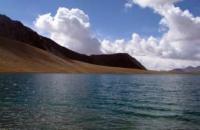
Lake Ekurgen-Kel.
Jeep tours over lakes of Kyrgyzstan.
«A lake is the landscape's most beautiful and expressive feature. It is earth's eye; looking into which the beholder measures the depth of his own nature»
Henry David Thoreau.
Walk in Barskoon and Dzhety-Oguz gorges.
Lake Ekurgen-Kel is located at an altitude of 3628.5 m. a. s. l. in an intermountain depression, on southern slope of Sook ridge, located 6.2 kilometers southwest of Sook pass located at an altitude of 4021 meters above sea level, 5.6 kilometers southeast of Sarytor pass, 4050 m. a. s. l., in Jetyoguz district of Issyk-Kul region.
The length of the lake from southwest to northeast is 1.5 kilometers, the width in the northeastern part reaches 930 meters, the maximum depth of the lake is 20 meters. The area of the lake is 1.03 square kilometers, the perimeter of the lake is 4.22 kilometers.
The Sarytor river flows into the southwestern part of the lake, which originates on the southern slope of the Sarytor pass located at an altitude of 4050 meters above sea level in the Sook ridge. For 4 kilometers from the pass to the confluence with Lake Ekurgen-Kel, the river is called Sarytor.
A river called Ekurgen flows out of the southwestern part of the lake. An unnamed river with a length of 3.9 kilometers flows into the southeastern part of the lake. The sources of this river are located in the main ridge of the Sook range at an altitude of 4465 m. a. s. l.
800 meters before it flows into the lake, at an altitude of 3682 m. a. s. l., the river receives a tributary 4.8 kilometers long on the left. The second tributary originates in the main ridge of the Sook Range at an altitude of 4522 m. a. s. l. When flowing into the lake, these tributaries form a swampy delta.
The transparency of the water in the lake reaches 8-12 meters. In the lake in a small amount in the lake there is fish, mountain osman. The relief of the bottom is represented by stone and gravel screes, smoothly turning into the bottom of the lake.
Geographic coordinates of Lake Ekurgen-Kel: N41°43'48 E77°43'40
Authority:
Alexander Petrov.
Photos by:
www.dive.kg