


![]()
Вы здесь
Nature of Dzhungarskiy Ala-Tau.
Tours and walks Dzhungarskiy Ala-Tau in Kazakhstan.
“Nature is an infinite sphere whose center is everywhere”
Ralph Waldo Emerson.
Private Tour in Kazakhstan.
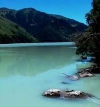
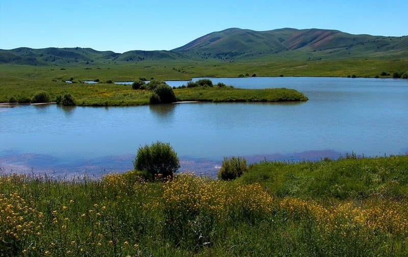
Dzungarian Alatau Mountains stretch from southwest to northeast along the state border of the Republic of Kazakhstan and the Republic of China, between the Ili River and Alakol Lake, and are located on the territory of Almaty and East Kazakhstan regions.
On the east it is delimited with Zhungar Gates from the ridges of Barlyk and Maily located on the territory of China, on the south it is separated from Tien Shan by the Valley of Ili River. Total length of Zhungar Alatau is about 400 km.
Like Saur and Tarbagatai ridges, Zhungar Alatau occupies the intermediate position between Tien Shan, the typical Central Asian mountain system, and the mountains in the south of Siberia.
The system of Zhungar Alatau consists of several parallel high chains; the major of them is Severny ridge, the longest. It stretches in the north accompanied from the northern side by small and short front ridges.
South-western branch of Severny ridge is Karatau ridge. Deep tectonic depression occupied by Koksu River separates the southern group of ridges from Severny Ridge: Toksanbai, Bedzhintau and Tyshkantau, which join with the branches of the Chinese ridge Boro-Horo.
Toksambai and Bedzhintau ridges are connected to the main northern chain by means of the bridge that serves for water separation between the upper courses of Koksu and Borotal rivers.
Jungar Alatau is situated in the eastern part of Kazakhstan, it stretches from west-south to east-north along the state borders of the USSR and China, between the river Ili and Alakol lake.
On the east it delimits by Jungarian gates from ridges Barlyk and Maili which are situated in the territory of China, in the south by the valley of the river Ili from Tien-Shan. Like the ridges Saur and Tarbagatai Jungar Alatau occupies an intermediate place between Tien-Shan.
Here are spreaded such bushes as archa, Tien-Shan fir-tree. Suslov S.P. (1954) noticed the most dominated kinds of plants- the Altai-Siberian in Jungar Alatau. Jungar Alatau mountain system consists of some high ranges; the longest of them stretches in the north.
To the south from the main range situated Toksanbai, Bedzhyntau and Tyshkantau ridges, which connected with spurs of China ridge Boro-Horo. Toksanbai and Bedzhyntau ridges are connected with the main northern range-dam, which is the watershed between the uppers of Koksu and Bortala rivers.
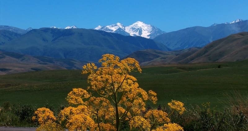
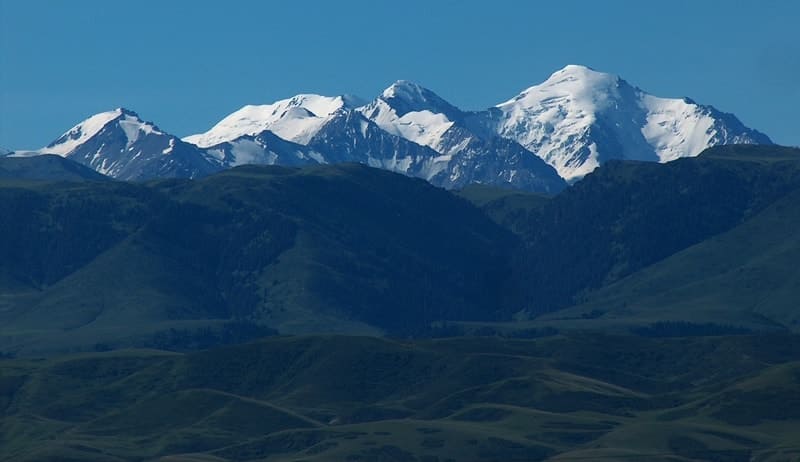
The height of the main ridges of Jungar Alatau is above 4000 meters above sea level, the northern range’s height is 4442 meters above sea level (Besbaskan). The ridges have snowy peaks and glaciers with the length to 8km.
To the west, south-west and north-west of high snow ranges there are many spurs. Jungar anticlinori is the base of the mountain system, which contains in it’s nucleus the stratums Paleozoic, rifei and proterozoi which sometimes found a fan-shaped structure.
Jungar Alatau is like a raising arch, complicated with bursts which escorted the neogen-quarternary rising of mountains. In bursts appeared some spurs. To the relief are typical high plateaus, which are situated on the different levels.
These plateaus give it graded features. In high mountains here are plateaus, which are higher the Kolesnik (1933), Udichev (1940). An ancient surfaces of the leveling, which were risen to the height of 3000 – 4000 meters above sea level shows about the rising of the mountain.
The snowy line in Jungar Alatau is situated on the height of 3200 – 3800 meters above sea level (on the northern side lower, on the southern higher). The area of freeze is about 1000sqkm.
The number of glaciers is 1369. At a height of 2600 – 2800 meters above sea level is permafrost. The lower parts of mountainsides are covered by desert (in the south ), semi-desert and stepped plants.
Mountain steppes are mainly feather-grass and in the south here are tipchak. In high zone from 1500 to 2400m on the northern mountainside spreaded meadow -forest plants. Here are spreaded sparse growth of trees from Tien-Shan fir-tree; also here are area of thick fir-trees.
To the Tien-Shan fir-tree mixed Siberian fir-tree. Under the meadow here is-mountain-meadow black soil, under the forest-dark-colored forest soils. Lower of fir-tree zone spreaded bushes. In the upper mountainside spreaded mountain-meadow plants.
In lower parts of Alpian area-grassed. Fauna of Jungar Alatau is like in Tien-Shan. Jungar Alatau is divided into two physic-geographical provinces: Jungar Alatau, in which included the main part of mountain system, and Western-Jungar which occupies western and southern mountainsides.
In Jungar Alatau located polymetallic (Tekeli deposit), cupric and iron-stones also ferrous and non-ferrous metals. In foothills of Jungar Alatau spreaded field-crop cultivation and gardening.
On the mountain pasture is developed stock-breeding and cattle-breeding. Average height of Zhungar Alatau is 3580 meters above sea level. Main ridges of Zhungar Alatau rise above 4000 meters above sea level, the northern, main chain rises up to 4560 meters above sea level (Semenov-Tien-Shansky Mountain in the heads of Bolshoi and Malyi Baskan Rivers). Average height of Toksambai and Tyshkantau ridges is 3770 meters above sea level, the highest point of the former is 4062 meters above sea level, and of the latter is 4359 meters above sea level.
Significantly exceeding the level of the snow line, ridges have snow tops and glaciers up to 8 km. There are a lot of branches that go to the west, south-west and north-west from the high snow chains. Along the skirts of Balkhash Valley there rise south-western ridges of Zhungar Alatau.
Western ridges of Zhungar Alatau are mountains of Chulak, Matai, Kalkany and their under-mountain valleys. This is one of the most picturesque places in Kazakhstan. Here one can still meet ibex, mountain beavers – wild sheep, and here the delicate desert gazelle (dzheiran) is breeding.
Previously destroyed in the northern deserts koulans were brought here from Barsakelmes peninsula. Besides, this territory is amazingly rich with ancient monuments: in the mountains there are many rock paintings that require world protection, in the under-mountain valley there are many burial mounds and ritual constructions made of enormous stones.
The Zhungar Alatau - often written in the Russian spelling as Dzhungarskiy Alatau- stretches over 300 kilometres from southwest to northeast along the border with China. Its highest summit, Semyonov Tienshanskiy 4622 meters above sea level, is metres high and situated to the south of Sarkand directly on the Chinese frontier.
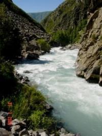
Almost the entire area is a border district (requiring an entry permit) and therefore hardly developed and little-explored by tourists. Nevertheless, this sparsely occupied mountain region with its glaciers, forbidding summits, untamed streams, remote valleys, hoi springs and clean air has huge tourism potential for mountain climbing, rafting, trekking, photo safaris and silent communication with nature at its most impressive.
As with other remote areas, visitors stand a very good chance of meeting nomads and their herds who have preserved much of their traditional lifestyle. A particularly interesting attraction the valley offers is its relatively large population of Tien-Shan brown bears. In spring, accompanied by a gamekeeper, you can venture into the wilderness with a good chance of observing one of the hungry bears through binoculars, recently woken from hibernation and looking for food.
For fishermen, the osman, a capricious, predatory fish that usually only bites during the second half of the day, lives in the crystal-clear streams of this region. The passes and glaciers in this area arc no less fascinating than those in the Zailiyskiy Alatau, even though climbing up to the glaciers Tronova, Ayuksayskiy, Sapozhnikova and Altynsarina requires good mountaineering expertise.And remember: you are in a border area and must be in possession of a valid entry permit.
Geographic coordinates of Dzungarian Alatau mountains: N45°04'06.16" E80°16'31.92"


Authority:
The guidebook across Kazakhstan. Authors Dagmar Schreiber and Jeremy Tredinnick. Publishing house "Odyssey".2010. "Zhetysu is the Land of tourism”. A Tourist Guide-book. Almaty. 2003. 68 p. and the material for this page is taken from the printed edition.
Photos by
Alexander Petrov.