


![]()
Вы здесь
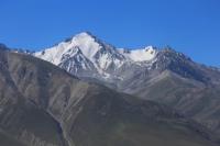
Borkoldoy ridge.
Kyrgyzstan Tour & Travels.
“Beauty is a manifestation of secret natural laws, which otherwise would have been hidden from us forever”
Johann Wolfgang von Goethe.
Trekking Along Tien-Shan mountains.
Borkoldoy (Kyrgyz. Borkoldoy too) - a mountain range located in Tien-Shan mountains, in the southeastern part of Kyrgyzstan in Dzhety-Oguz district of Issyk-Kul region. Ridge is 64 kilometers southwest to northeast.
The greatest width in the central part is 27 kilometers. The average height is 4300 meters above sea level, the maximum mark (in the western part) is 5049 meters above sea level. There is significant glaciation on the northern slope.
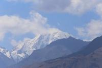
The ridge is composed of crystalline schists, marbles and granites. Semi-desert vegetation predominates on the slopes, above - rocks and talus with sparse xerophytic vegetation. The Borkoldoy Ridge is located to the north of Western Kokshaal-Too in the place of its powerful glaciation, where the peaks are located more than 5000 meters above sea level.
The southern borders of the ridge are the sources of the Uzengegush - Kotur River. From the southwest, the borders of the ridge are the Chakyrkorum river, in the north the Karasai river. In the east, the borders of the ridge are the Kichi-Uzen-gush river and the sources of the Karasai river - the Ashisu river.
The most significant glaciation of the Borkoldy Ridge (average height 4300 meters above sea level, maximum 5170 meters above sea level) - 396 glaciers with a total area of 250.3 square kilometers. The Borkoldoy Ridge is a complex, deeply dissected system of mountain ranges about 64 kilometers.
Most of the glaciers are located on the northern slope in the basins left tributaries of the Naryn rivers - the Karakol, Chakyrkorum and Tuyuk-Chakyrkorum rivers. The Borkoldoy Ridge has a latitudinal strike. The ridge rises like a steep wall over the channel of the Chon-Uzengegush River.
The narrow side valleys cutting the southern slope are characterized by extremely steep dipping, rivers often eroding the right and left sides of the valley down to rocky parent rocks. The upper reaches of this valley are cut to the very crest of the ridge and have the character of hanging troughs.
In different areas of the ridge, access is carried out in different directions. Thus, access to the northern, eastern and southeastern slopes and gorges of the ridge is possible from the side of the Barskoon gorge and through the village of Karasai.
Access to the southern slopes and the inner part of the ridge is possible only from the side of the city of Naryn, through the village of Akmuz and further into the valley of the Myudrum River. The region has not been sufficiently developed, from a huge number of peaks that have not been conquered.
The ascents were made to about 20 peaks. More than a hundred peaks above 4000 meters above sea level and 8 above 5000 meters above sea level await their first climbers. Both the area itself and the locations of the base camps can only be reached by off-road vehicles.
The drive from Bishkek takes 2 - 4 days. The area is deserted, you can find only a few hunting farms and shepherds' camps. Access to the territory of hunting farms may be closed, therefore it is better to contact the management of hunting farms in advance and request the possibility of staying on their territory.
The area is located in the border control zone and you need to issue passes to access it. The first European who visited these places and made the first ascent of Mount Kzyl-Ompol was the Hungarian scientist and traveler Gustav Prinz. In 1995, Otto Chkhetiani traveled to this area.
The vegetation is extremely scarce due to the dry climate. There is practically no woody vegetation; in the valleys of the Borkoldoy ridge, there are low thorny bushes. Aksay sirts are a real desert - rare pieces of dried grass are interspersed with areas of high-mountain takyrs.
The fauna is quite rich - marmots, hares, small rodents, foxes, mountain goats, rams, wolves, snow leopards, bears.
Geographic coordinates of Borkoldoy Ridge: N41 ° 22'08 E77 ° 45'45
Authority:
http://itmc.travel
Photos by
Alexander Petrov.