Вы здесь
Angren plateau.

Tours on the Angren plateau.
“Nature will tell you a direct lie if she can”
Charles Darwin.
Sights of the Angren plateau.
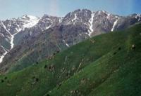
The Angren plateau which area about 1200 sq.km, represents the ancient surface which is intensively developed by a modern erosion. The highest point of the plateau - 3400 m, the lowest - 2100 - 2400 m. On these high uplands numerous sources of Kasansaya, Akhangarana (Angren), Gavasaya, Chadak, etc. originate.
The majority of the rivers beginning on the plateau at an exit form of it deep gorges, and some, for example Gava, Bozteke upper courses, Karaarchi, wild and are impassable. Is divided an upper course of the plateau Gavasaya into two unequal parts, each of which has the inclination of a surface.
It is possible to get on the Angren plateau in the different ways. The next and the most convenient of them - on the way to Chapcham's pass. Where sources of Kasansaya - Chapchama and Chalkodyu merge, a pedestrian part of a route begins.
The good track leaves from the road up the last to the valley and through 13 km rises by the pass Chalkodyu. Other way on the plateau and in Akhangaran's upper course - from the valley of the river Sumsar. In this valley there is a working settlement of Sumsar.
Some distance up the river goes the road, and the track begins then. Approximately in 10 km from the settlement the valley turns on the East and has the width pro-deleting. Here the river carries Kugala name (or Kugala).
Almost throughout to the upper course it flows on the wide floodplain. Begins Kugala on east slope of the ridge of the same name where heights have marks to 3700 m. Side slopes are abrupt also skalist, it is a lot of taluses.
From Kugala pass (about 3500 m) the wide panorama on the West opens. Snow on it, top of Babayob, an arashansky part of the Chatkal Range, the mountain on the left river bank Ters are visible the Angren plateau with twisting.
From here tracks disperse on a crest in different directions that below, at the lake Kugala to meet again. To the lake it is possible to climb the rivers Koksarek and Gava.
Authority:
V. N. Popov. "The western Tien Shan. M, "Physical culture and sport", 1978.


