Вы здесь
Tamgaly petroglyphs.

Tours Tamgaly petroglyphs.
"This stone is a sandstone, 3 cubic fathoms in size, with wedge-shaped hieroglyphs and colored patches carved into it, with which the Kirghiz decorated the bushes of boyalish surrounding the stone; this custom was adopted from the Mongolian peoples and expresses a sacrifice for the successful crossing of the desert; there is a large Kirghiz cemetery nearby"
Description of the stone with the inscription Tamgalytas. Military surveyor, topographer Yuliy Aleksandrovich Schmidt. 1894 (pp. 59 - 60).
In 1895, he was awarded the silver medal named after N.M. Przhevalsky for geodetic work in Central Asia.
Best petroglyphs tours Kazakhstan.
Tamgaly Museum Reserve is located at an altitude of 881 to 893 meters above sea level, located in southeastern part of Karakyr Mountains, in small Tamgaly gorge, 5 kilometers northwest of village of Karabastau, 127 kilometers northwest of Almaty is in Zhambyl district in western part of Almaty region.
The geographical area belongs to the arid desert zone with an extreme continental climate. The few rivers often dry up in the summer, the main ones being the Tamgaly and the Oysu, right tributaries of the Ashysu River. Rare plant species in the Chu-Ili mountains are listed in the Red Data Book of Kazakhstan.
Wild animals include wolves, foxes, rabbits, turtles, snakes, and many birds, including steppe eagle, falcon, saker falcons. Neotectonic movements played a major role in shaping the picturesque landscape of Tamgaly. Mountain borders and a broad plain to the north are along a seismic fault which lifted the surface and formed a high ledge, while water-and wind-erosion formed a network of river valleys and upland relief.
A striking feature of Tamgaly Valley is a small canyon at the mouth of the gorge. Rocky slopes almost converge there on the contours of the valley. Wide and smooth rock surfaces are covered with dense “desert patina” and served as a perfect background for numerous petroglyphs.
There are more than 100 different sites-settlements, burial grounds, altars, and concentrations of petroglyphs within a territory of about 900 hectares, dated from the middle of the 14th - XIIIth centuries BC until the turn of the XIXth - XXth centuries AD.
The settlements are located exclusively in the mountainous part of the gorge. They occupy a small area (300 - 1,200m2) in different geomorphic conditions. Many are multi-layered sites containing cultural relics of several historical eras.
Excavations were carried out on the settlements called Tamgaly I and V.
The stratigraphy of Tamgaly I includes cultural layers of four historical periods: Late Bronze Age (XIIth - Xth centuries BC), Early Iron Age (two stages: VIth - Vth to IVth centuries BC; IInd century BC to Ist century AD), as well as the late Middle Ages (XVIth - XVIIth centuries) and modernity (XIXth - XXth centuries).
For the different layers of the settlement we have more than a dozen 14C and ESR dates. Building stones with petroglyphs were found in the cultural layers; the most representative series of images was dated to the turn of the Vth - IVth centuries BC.
Ancient burial sites are located in the mountainous and plain parts of Tamgaly Gorge. Bronze Age burials at Tamgaly I, II and Karakuduk II were excavated in the piedmont plain. The mountainous area contains Tamgaly IV - VII burials.
Sites typologically belong to the Atasus and Semirechie versions of the Andronovo cultural-historical community and date from the XIVth - XIIIth to the Xth centuries BC.
Burial mounds, everywhere in the gorge, present several types from the features of mounds and burial structures. The largest burial grounds (two or three dozen burials) are located on the piedmont plain. The burial sites investigated by Maksimova A.G. in 1957 are dated to the IIIrd century BC – IInd century AD.
A mound with stone-revetments is especially notable. A mound with a burial from the Vth - IVth centuries BC was researched at Tamgaly VI. Three ritual ring fences with a “deer” stone inside one of them were identified in Karakuduk II dating to the Vth - IVth centuries BC.
Medieval burials in Tamgaly are absent. Ancient quarries were found near Bronze Age burial sites at Tamgaly I, II and VI. The core of the complex is Tamgaly Canyon, with about 3,000 petroglyphs, tentatively marked as groups I - IV; the total number of rock carvings including the peripheral locations is about 5,000 pictures.
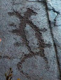
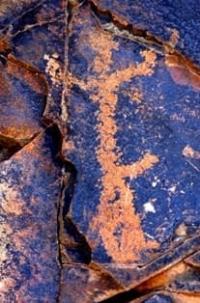
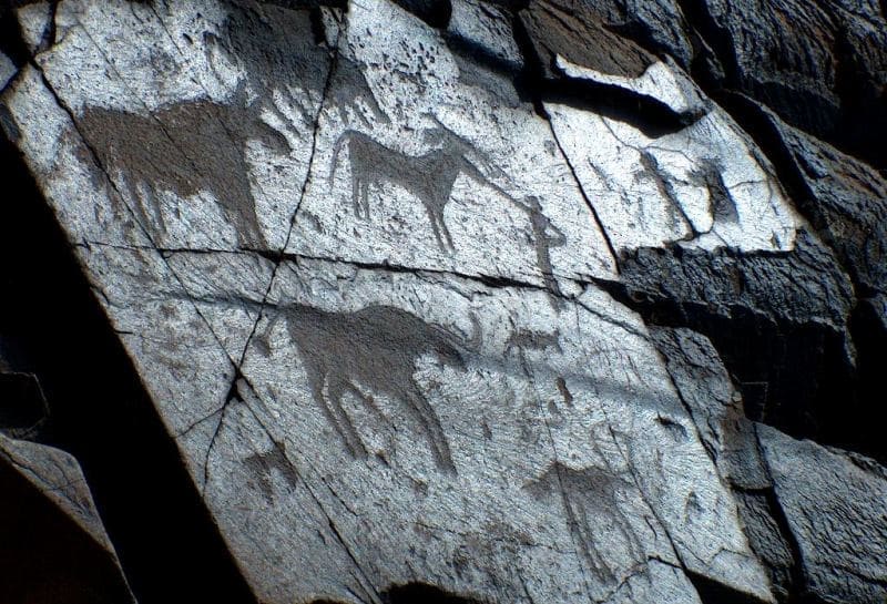
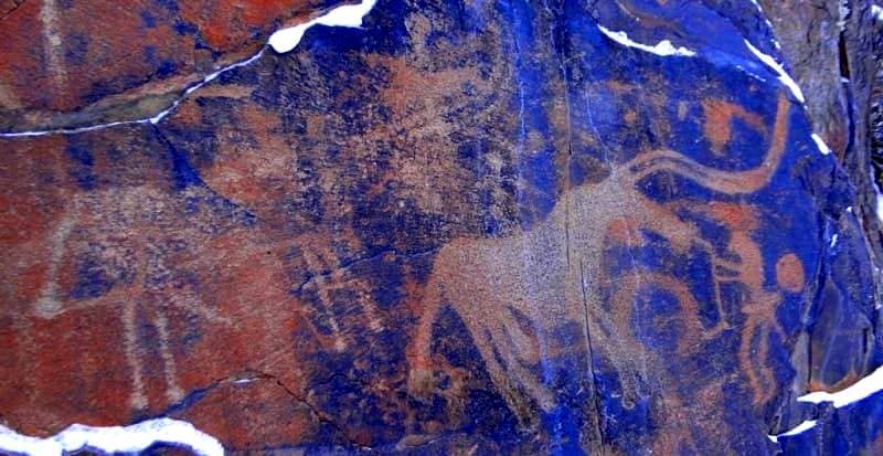
Tamgaly Bronze Age petroglyphs are unique in Central Asian rock art. The oldest series of rock images identified as the Tamgaly-type of petroglyphs has the most aesthetic and cultural value. They are distinguished by their large-size (from 25 - 30cm to 0.7 - 1.0m), vivid naturalistic style and their rich repertoire (anthropomorphic solar deities, “masks", club-carriers, an archer in a wolf mask, chariots, hoof prints, spectacle-shaped signs as well as images of bulls, Asiatic wild asses, horses, camels, wild boar, wolves, deer, etc.).
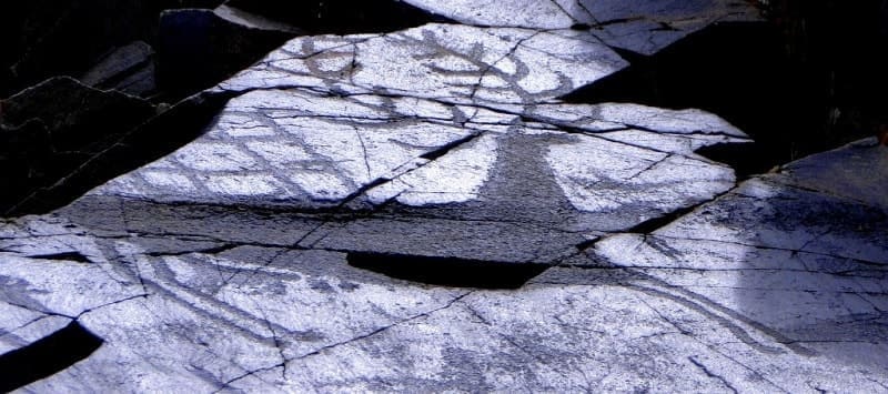
A masterpiece of prehistoric rock art is a vertical panel (group IV, site 118) with images of 6 - 7 solar characters, ten dancing male warriors with weapons, birthing women, erotic scenes and “worshippers”. On the panel, there is a kind of hierarchy with three groups of characters: the highest level is occupied by solar deities; below them are a series of similar figures of dancers and birthing women and a “worshipper” at the bottom.
Solitary images of different “sun-headed” types also exist in Tamgaly groups II, III, IV and V, but only in the former place are all the solar characters united in a single panel which allows us to consider it as an image of the pantheon. In Tamgaly, out of a total of 30 “sun-headed” images recorded, 26 still remain.
Tamgaly-type petroglyphs are distributed unevenly throughout the area of the gorge, mainly on the rocks in groups I - V, IVa, with more than 1,000 isolated images, also found in several peripheral locations of the Tamgaly complex, dated to the second half of the XIVth – XIIth centuries BC.
Their area is limited from the central part of the Chu-Ili Mountains to the Chu Valley and the northern Issyk-Kul region. Late Bronze Age (XIIth - Xth centuries BC) petroglyphs are outnumbered by the drawings of previous periods and differ significantly from them in technique, style, repertoire, localization within the Tamgaly complex.
Their repertoire looks poorer, with images of horses, bulls and wild animals being prominent; complex, syncretic images become rare. Images from the transitional period from the Bronze Age to the Early Iron Age (beginning of the 1st millennium BC) form a particular small group.
Almost no human figures are present, giving way to stylized images of deer, wild goat, and predators - wolves, wild boar, panthers. Their artistic style and compositional arrangement, due to the choice of vertical stelae-shaped planes, connect these petroglyphs with the pictorial tradition of Western Mongolia and Altai “deer” stones.
Images of the Early Iron Age form the largest group of Tamgaly petroglyphs. They are mainly concentrated in groups IV and V and at the periphery of the complex-everywhere around the settlements, burial mounds and on hill tops. A remarkable series includes images of wild animals in the Saki animal style-a specific artistic style of Central Asian Animalism of the VIth - IVth centuries BC.
Their appearance is connected to the massive retouching of Bronze Age drawings in groups III-V, where Saki petroglyphs are often clumsily carved onto ancient images. In addition, a huge amount of non-realistic engravings exist on the Tamgaly rocks.
Petroglyphs dating to the Middle Ages are everywhere, although their total number is relatively small. On canyon rocks, they prevail in groups IV and V, but the best examples are presented in several peripheral locations along the main roads and mountain trails of a gorge.
Medieval engravings with a special repertoire and artistic originality were made by Central Asian nomads (VIth - XIIth centuries). The main character of the panels is a mounted horseman-standardbearer, archer, or a heavily armed warrior.
New pictorial motifs include a duel between mounted and dismounted warriors, hunting scenes, migrations.
With few exceptions, the drawings were pecked superficially and many images incised with a sharp metal tool. Massive re-carving of ancient drawings becomes popular, with the addition of new elements changing the original content of images. A striking example is the image of a bull from the Bronze Age (III group, Site 23) transformed into the figure of a rider.
A large image of an elephant with a rider near the settlement of Tamgaly I, and the figure of a seated anthropomorphic character (deity?) in group V, resembling the early medieval frescoes of Sogdiana, are rare in Central Asian rock art.
A special category of engravings includes ancient Turkic tamgas-signs of tribal affiliation and tribal property.
There is also a short runic inscription dated to the IXth - Xth centuries. An Oirat inscription on the rocks of group IV depicting a six-syllable mantra “om ma ni pad me hum” is dated to the last decades of the XVIIth – middle of the XVIIIth centuries.
Kazakh folk-images from the XIXth - early XXth centuries show the last attempts at rock art. Limited to images of goats, horses and horse riders, they are mostly found near the wintering grounds of settlements; lineage tamgas are often depicted along with figures of people and animals.
The special cultural significance of the Tamgaly complex is due to a number of specific features. Many pictorial traditions typical of Kazakhstan and Central Asian rock art are concentrated there. The petroglyphs and other Tamgaly sites illustrate the evolution of the subjects and forms of rock art over three millennia against the background of the historical development of nomadic cultures in the arid zone of Central Asia.
Rock drawings and some Tamgaly sites were discovered for the first time in 1957 by Maximova A.-G. (Semirechie’s Party of Southern Kazakhstan Expedition from the Institute of History, Archeology, and Ethnography of AS of the KazSSR).
Geologists Medoev A.G. and Aubekerov B.Zh., archaeologists Maryashev A.N., Yermolaeva A.S. researched the site in the 1970 - 1980.
Rogozhinsky A.E. researched it in 1988 - 2005. In 1990 - 1994, the “Kazproektrestavratsiya” Institute initiated a comprehensive archeological geomorphologic research and preservation of petroglyphs, continued in 1998 - 2005 by KazIRP MMC (Rogozhinsky A.E., Aubekerov B.Zh., Ripinskaya E.N., Charlina L.F., Horosh E.H.), in partnership in 2002 - 2005 with A.-S. Higen (Riksantikvaren, Norway) and support from UNESCO.
Since 2001, Tamgaly has been on the State List of Sites of National Importance of Kazakhstan. In 2003, the State Historical-Cultural and Natural Preserve “Tamgaly” was created. In 2004, the petroglyphs of Tamgaly archeological landscape were included in UNESCO’s World Heritage List (Rogozhinsky et al. 2004).
Geographic coordinates of Tamgaly I petroglyphs: N43°48'14 E75°32'13
Geographic coordinates of Tamgaly II petroglyphs: N43°48'10 E75°32'04
Geographic coordinates of Tamgaly III petroglyphs: N43°48'13 E75°32'02




Authority:
“Rock Art Sites in Kazakhstan”. Alexey E. Rogozhinskiy.
Alexander Petrov
photos by:


