


![]()
Вы здесь
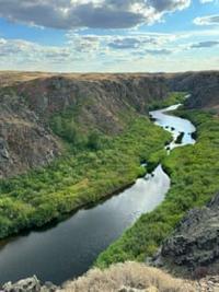
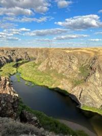
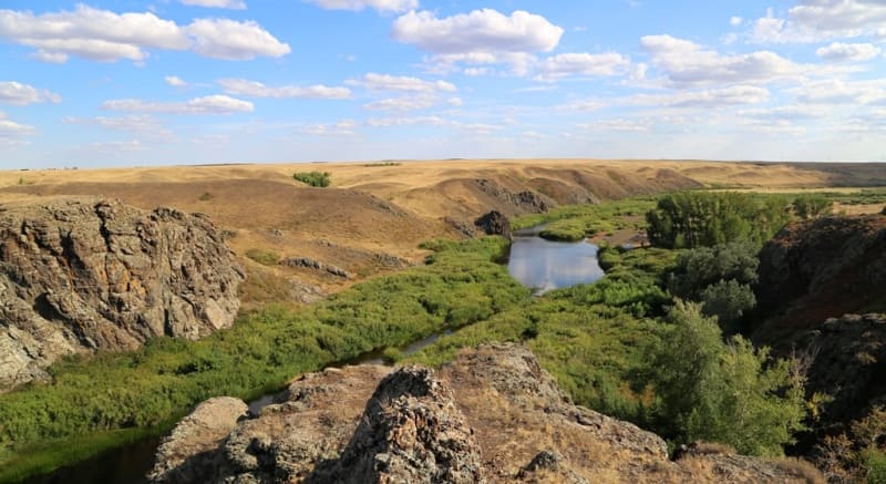
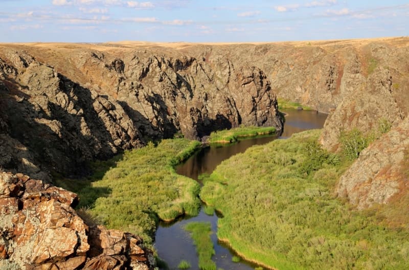
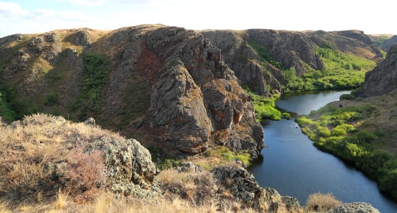
Silety River.
Central Asia on Silk Road Tour.
“Nature itself has it this way”
Livy.
Travel to monuments in Central Asia.
Silety River originates in north of Kazakh small hills, east of Popovsky Liman valley, between villages of Bozaigyr (former Elizavetinka) and Klyuchi in Shortandinsky district of Akmola region, flows through North Kazakhstan and Pavlodar regions and flows into bitter-salty lake Silety-Teniz located in south-eastern part of North Kazakhstan region.
The length of the river is 416 kilometers, the catchment area is 18,500 square kilometers. The width of the valley in the upper reaches is 500 - 700 meters, in some places 1.5 - 2 kilometers. The channel is 40 - 50 meters wide, sometimes 120 - 500 meters.
The average annual water flow near the village of Bestogai is 5.8 cubic meters per second. The banks are steep. Food is snow and spring. It freezes in October - November, opens in March - April. It gets shallow in the summer. The main tributaries: Koyandy, Akzhar, Zhartas, Kedey, Sholak-Karasu, Shiili.
The river belongs to the Irtysh River basin. The average annual water flow in the vicinity of the village of Bestogai is 5.8 cubic meters per second. In summer it often becomes shallow near the mouth. The river contains crayfish, pike, perch, roach, bream, pike perch, chebak, rudd, which indicates the purity of the water.
Almost all the tributaries of the Sileta are low-water, seasonal, drying up and not permanent. The river flows through the villages: Prirechnoye, Novomarkovka, Baysary, Seletinskoye.
Hydrography of Silety River.
At 6.2 kilometers from the beginning of its sources, the river crosses the Bozaigyr – Klyuchi highway.
For 17.5 kilometers, the Silety stream flows in a non-permanent, seasonal, sometimes drying bed.
At 17.5 kilometers the stream receives a small stream on the right, which originates south of the village of Bozaigyr.
After 19 kilometers from the beginning of its sources, the river forms the main channel,
At 23.5 kilometers the river flows into the Klyuchi reservoir, which is 1.9 kilometers long.
Tributaries of Silety River.
Koyandy River.
At 39.5 kilometers, the Koyandy River, 30 kilometers long, flows into Silety on the right. The Koyandy River originates south of the small mountains Kamennaya Sopka and north of lakes Tyshkan-Kol and Shoshkaly-Kol in the Arshalinsky district of the Akmola region.
After 9.3 kilometers from the beginning of its sources, the river receives a tributary on the left, which forms the main channel. At 11.4 kilometers from the beginning of its sources, the river flows into the Koyanda Reservoir.
Geographic coordinates of Koyanda River: N51°22'12 E71°42'02
River Askan-Ozek.
At the 61st kilometer, a small tributary of 17.5 kilometers long, Askan-Ozek, flows into Silety on the left. The river originates 16 kilometers southeast of the village of Zholymbet from numerous lakes in the small hills in the Shortandinsky district of the Akmola region.
Geographic coordinates of Askan-Ozek River: N51°35'25 E71°52'57
Akzhar River.
At 71.4 kilometers, the Akzhar tributary, 62.5 kilometers long, flows into Silety on the right. The river originates 16 kilometers southeast of the village of Zholymbet from numerous lakes in the small hills in the Shortandinsky district of the Akmola region.
At its source the river is called Maidan, at 14.7 kilometers the river reaches the lost village of Akzhar and hence gets its name – Akzhar. At 45 kilometers the river flows into the reservoir of the same name
Geographic coordinates of Akzhar River: N51°26'20 E72°01'34
Karasu River.
At the 92nd kilometer on the right, the Karasu tributary, 32.2 kilometers long, flows into Silety. The river originates in the interfluve of Akzhar and Ak-Myrza kilometers, north of the villages of Bulaksay and Erkinshilik from numerous lakes in the Shortandinsky district of the Akmola region.
Geographic coordinates of Karasu River: N51°32'51 E72°08'00
Akmyrza River.
At the 114th kilometer on the right, the Akmyrza tributary, 51 kilometers long, flows into Silety. The Akmyrza River is formed from the confluence of two tributaries: Kuanysh and Karasu. The confluence of the rivers is located 9.4 kilometers north and slightly west of the village of Erkinshilik in the Ereymentau region Akmola region.
Geographic coordinates of Akmyrza River: N51°40'59 E72°20'07
Karasu River.
The Karasu River, 34 kilometers long, is a left tributary at the confluence with the Kuanysh River. The Karasu River in its upper reaches is called Sholak-Karasu. At 25 kilometers from the beginning of its sources in Sholak-Karasu, an unnamed tributary adjoins on the left and the river receives the name Karasu.
Geographic coordinates of Karasu River: N51°40'59 E72°20'07
Sholak-Karasu River.
The Sholak-Karasu River, 25 kilometers long, merges with an unnamed tributary and receives the name Karasu.
Geographic coordinates of Sholak-Karasu River: N51°15'08 E72°33'58
Kuanysh stream.
The Kuanysh River, 24.3 kilometers long, is formed from the confluence of the Olzhabay and Karasu rivers.
Geographic coordinates of Kuanysh stream: N51°26'19 E72°43'01
Karasu stream.
The Karasu stream, 54.9 kilometers long, originates in the southern part of the Ereymentau Mountains and to the west of the Belodymovskie Dachas mountain range. At 15 kilometers from the beginning of its sources, in the vicinity of the Baymen fish pond, the stream merges with the right tributary of the Altyn-Tau, 8.7 kilometers long. Karasu Creek flows through Baimen Pond.
Geographic coordinates of Karasu stream: N51°26'19 E72°43'01
Altyn-Tau stream.
The Kuanysh River, 8.7 kilometers long, originates from the southern slope of the Altyn-Tau mountain, 750 meters above sea level, located in the Ereymentau mountains.
Geographic coordinates of Altyn-Tau stream: N51°19'28 E73°06'48
Olzhabay stream.
The Olzhabay stream, 39.5 kilometers long, originates from the southern spurs of the Ereymentau Mountains, north of Mount Zhylandy, 579 meters above sea level. At 8.5 kilometers from the beginning of the river there is a small reservoir. At the 20th kilometer there is another small reservoir.
At 23.5 kilometers the Bozbay tributary adjoins on the right. 1.9 kilometers north and slightly west of the village of Olzhabay, 103 meters from the right bank of the Olzhabay River, is the Olzhabay Batyru mausoleum. After 33.5 kilometers, the Shatandy stream, 33 kilometers long, adjoins on the right.
Geographic coordinates of Olzhabay stream: N51°14'32 E72°45'17
Shaitanda stream.
The Shaitanda stream, 33 kilometers long, originates from the northern slopes of the Ereymentau Mountains, northwest of the village of Kunshalgan in the Ereymentau district of the Akmola region.
Geographic coordinates of Shaitandy stream: N51°10'50 E72°59'02
Ashchylyairyk River.
At 141.3 kilometers on the left, the 60-kilometer-long Ashchylyairyk tributary flows into the Silety River. The Ashchylyairyk River is formed from the confluence of several rivers: the right tributary Karazhar, the middle tributaries Sarykamys and Tagyrysh and the right tributary Nurmagambet-Sai.
The middle tributaries Sarykamys and Tagyrash and the right tributary Narmagambut-Sai flow into a small reservoir located between the villages of Zholymbet and Novoselovka and from there flow into Ashchylyairyk. After 25.5 kilometers from the beginning of the source, the Tasmol tributary, kilometers long, flows into Ashchylyairyk on the left.
Geographic coordinates of Ashchylyairyk stream: N51°52'54 E72°12'00
River Tasmola.
After 25.5 kilometers from the beginning of the source, the Tasmol tributary, 46 kilometers long, flows into Ashchylyairyk from the left. The Tasmola stream, 7 kilometers from the beginning of its sources, receives on the right a tributary of Kyz-Karasu with a length of 27.5 kilometers.
The sources of Tasmol are located in the southeast of the salt lake Zharsor located at an altitude of 317 meters above sea level.
Geographic coordinates of Tasmola stream: N51°57'11 E71°51'58
Kyz-Karasu stream.
The Tasmola stream, 7 kilometers from the beginning of the Tasmola sources, receives on the right a tributary of the Kyz-Karasu with a length of 27.5 kilometers. The sources of the stream are located south of the village of Azat (former village of Ivanovsky).
Geographic coordinates of Kyz-Karasu stream: N52°01'55 E71°44'01
Ashylyozek stream.
14 kilometers before the mouth of the Tasmola, the Ashchylyozek tributary, 34.5 kilometers long, flows into the right. The sources of the stream are located east of Lake Kotyrkol, located at an altitude of 372 meters above sea level, and northwest of Mount Shorkar, 412 meters above sea level.
At 12.5 kilometers from the beginning of its sources, the river passes through the reservoir. After 20.5 kilometers, the kilometers-long Sholak-Karasu tributary flows into the right.
Geographic coordinates of Ashchylyozek stream: N51°54'56 E71°46'26
Sholak-Karasu stream.
After 20.5 kilometers from the beginning of the sources, the Sholak-Karasu tributary, 12.5 kilometers long, flows into Ashchylyozek on the right. The sources of the stream are located east of Mount Shorkar, 412 meters above sea level.
Geographic coordinates of Sholak-Karasu stream: N51°53'08 E71°40'38
Kedei River.
At 161 kilometers on the right, the Kedey tributary, 44 kilometers long, flows into Silety. Silety is formed from the confluence of two tributaries Kumaya and Tamdyozek. The sources of the Kedey River are located on the territory of the Buirytau Natural Park, 7.8 kilometers southeast of the village of Turgai and 5 kilometers east and slightly north of the Karagaily mounds. Most often
Geographic coordinates of Kedei River: N51°43'11 E72°42'43
Tributaries of Kedei River.
Turgaika stream.
After 26.5 kilometers from the beginning of its sources, the drying Turgai stream, 37 kilometers long, flows into Kedey on the right. The sources of the stream are located 10 kilometers southwest of the Karatumsyk mountain range.
Geographic coordinates of Turgaika stream: N51°50'29 E72°48'36
Taskuduk stream.
At 30.5 kilometers from the beginning of the source, the Taskuduk stream, 17.5 kilometers long, flows into Kedey on the left. The sources of the stream are located northwest of the Falcon Mountains.
Geographic coordinates of Taskuduk stream: N51°45'11 E72°33'22
Kumaya River.
The Kedey River is formed from the confluence of two tributaries Kumaya and Taskuduk. The non-permanent, drying Kumaya stream, 36.5 kilometers long, flows from the left into the Kedey channel. In turn, the Kumaya stream is formed from the confluence of two tributaries: the right Aktasty and the left Idege.
Geographic coordinates of Kumaya stream: N51°40'40 E72°47'02
Zharyk stream.
After 8.3 kilometers from the beginning of its sources, the Zharyk tributary, 14.3 kilometers long, flows into the Kumaya stream on the left. The Zharyk stream is formed from the confluence of the Beskempir tributary and an unnamed tributary on the right. At the 8th kilometer from the beginning of the source in Zharyk, an unnamed stream adjoins on the left. After 12.6 kilometers another unnamed stream adjoins on the left.
Geographic coordinates of Zharyk stream: N51°27'59 E72°57'09
Beskampir stream.
The length of the Beskempir stream is 13.5 kilometers. The sources of the stream are located northwest of the village of Algabas and northeast of the Sarytobe hillock, 548 meters above sea level.
Geographic coordinates of Beskempir stream: N51°22'51 E73°05'04
Aktasty stream.
At 10 kilometers from the beginning of the source in Idega, the Aktasty tributary flows into the right. The length of the Akitasta stream is 24.5 kilometers. The sources of the stream are located just north of the Baipak hill, 452 meters above sea level. Aktasty flows through the Ereymentau nature reserve.
Geographic coordinates of Aktasty stream: N51°29'40 E73°09'39
Idige stream.
The Idege stream is formed from the confluence of two tributaries: Agashty and Zhartas. The length of the Idege stream is 10.4 kilometers. At 9 kilometers from the beginning of the source, an unnamed tributary flows in on the right. At 10 kilometers from the beginning of the source in Idega, the Aktasty tributary flows into the right.
Geographic coordinates of Idege stream: N51°27'48 E73°02'35
Zhartas stream.
The length of the Zhartas stream is 8.5 kilometers. Zhartas originates in the Ereymentau nature reserve.
Geographic coordinates of Zhartas stream: N51°26'06 E73°08'36
Agashta stream.
The length of the Agashty stream is 6.7 kilometers. The Agashty stream originates in the Ereymentau nature reserve.
Geographic coordinates of Agashty stream: N51°28'05 E73°08'51
At the 177th kilometer from the beginning of the source, the backwater of the Siletinsky reservoir begins.
Sholak-Karasu stream.
At the 19,8th kilometer on the left, the drying, seasonal tributary Sholak-Karasu, 18.8 kilometers long, flows into the western part of the Silety Reservoir. The mouth of the stream is at altitude 221 meters above sea level. The sources of the stream are located east of Mount Iiradyr, 397.5 meters above sea level.
Geographic coordinates of Sholak-Karasu stream: N52°05'52 E72°28'50
At kilometer 212, the Seletinsky reservoir dam and the end of the reservoir. The length of the reservoir is 35 kilometers.
Shaitan-Karasu stream.
At the 218th kilometer, the Shaitan-Karasu tributary, 25 kilometers long, flows into the right. The sources of the stream are located northeast of the villages of Bayasary and Bestogai.
Geographic coordinates of Shaitan-Karasu stream: N52°06'45 E72°48'06
Kiikbay stream.
At the 225th kilometer, the Kiikbai tributary, 32.5 kilometers long, flows into the left. The sources of the stream are located south of Mount Zhaksyalimbet, 248 meters above sea level.
Geographic coordinates of Kiikbay stream: N52°12'48 E72°47'49
Shiili stream.
At 231 kilometers the Shiyli tributary, 52.5 kilometers long, flows into the right. At 30.3 kilometers from the beginning of the headwaters of the Shiyli stream, the Karsakbay tributary flows into the right. The sources of the stream are located southwest of the small Zhanaadyr mountains and east of Lake Shireukaol, located at an altitude of 287 meters above sea level.
Geographic coordinates of Shiili stream: N52°10'25 E72°56'17
Karsakbay stream.
At 30.3 kilometers from the beginning of the headwaters of the Shiili stream, the Karsakbay tributary, 26.5 kilometers long, flows into the right. The sources of the stream are located southeast of the Zhanaadyr Mountains.
Geographic coordinates of Karsakbay stream: N52°03'56 E73°04'25
At 242 kilometers is the beginning of the Siletinsky Canyon, at 268 kilometers is the end of the canyon. The length of the Siletinsky (Bestobe) canyon is 26 kilometers.
At 300.5 kilometers is the border of Akmola and North Kazakhstan regions.
At kilometer 330 the beginning of the wetlands.
Starting from 330 kilometers, on the border with the North Kazakhstan region, the Silety River enters a wetland with a large number of salt lakes, connecting and meandering river beds - Karatal, Korzhubay, Koshbaikol, Bukpa. For 86 kilometers, the Silety River flows in a swampy area before flowing into the bitter-salty lake Silety-Teniz.
At 334 kilometers the Karatal tributary flows in on the left.
At kilometer 342 is the border of the North Kazakhstan and Pavlodar regions.
At 365 kilometers the Bukpa tributary flows in on the left.
At kilometer 396 the beginning of the wetland.
At the 416th kilometer, the mouth of the Silety River into the bitter-salty lake Silety-Teniz, located at an altitude of 65 meters above sea level in the Ualikhanovsky district in the southeast of the North Kazakhstan region
Geographic coordinates of sources of Sileta River: N51°29'47 E71°14'49
Geographic coordinates of Sileta River: N52°23'37 E73°05'43
Geographic coordinates of mouth of Sileta River: N53°04'49 E73°23'30

Authority and photos by
Alexander Petrov.