Вы здесь
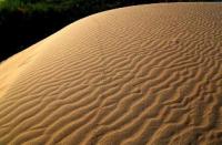
Sands Kyzylkum on Mangyshlak.


Foreign Independent Tour on Mangyshlak.
“Go through many roads, go back to your house, and look at everything as if for the first time”
Boris Andreev.
FIT trip to Tuzbair and Ustyrt palateu.
The Kyzylkum sands are located in the Mangistau region in the north of the Mangystau region. The sands are located in the western part of the Buzachi Peninsula in the latitudinal direction. In the northwestern part of the Kyzylkum sands are the Yermeken and Akbala necropolises.
In the western part of the Kyzylkum sands are the necropolises of Karash, Kapan-Aulie, Shalaktam and Karazum. The length of Kyzylkum sands from west to east is 48 kilometers, the greatest width in the central part, from the village of Tushchykuduk and to the north, 11 kilometers.
In the central part and in the west, the sands border the Sholshagylkum sand massif. In the central part of the sands from the village of Tushchykuduk and to the west to the small village of Kiyakty in the sand there is an extensive aquifer.
Thanks to the aquifer, a large number of freshwater artesian wells were drilled for 19 kilometers, which ensured water consumption. In the western part, in the vicinity of the village of Kiyakty and further to the north-west, a highway cuts through the sands to the Karazhanbas and Kalamkas oil fields.
In the southwestern part, the sands border the Uakkum sands. In the northern and eastern parts of the sands there are marshy salt marsh depressions from –5 to –19 meters below sea level, to which salt water wells are confined.
The Kyzylkum sands are located in the depression, represented by hilly and cellular fixed sands. The height of the sand mounds is not more than 3 meters, the depth of the sand cells is up to 3 meters. In the sands of Kyzylkum grow a feather grass, comb wheat grass, zhuzgun, weeds, biyurgun from shrub in the sands are represented by Saxaul.
Geographical coordinates of the central part of the Kyzylkum sands N44 ° 45'46,20 "E51 ° 50'33,61"
Authority and photos
Alexander Petrov.


