Вы здесь
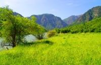
Sairamsu Gorge in Ugam Range.


Journey through Sairamsu Gorge.
“The creation of a thousand forests is in one acorn”
Ralph Waldo Emerson.
Trip from Shymkent to Sairmasu gorge.
The Sairamsu gorge is located on the northern slope of the Ugam range in the mountain system of the Western Tien-Shan in the Tolebi district of Turkestan region. The gorge is located on the territory of the Tolebi branch of the Sairam-Ugam National Natural Park.
Sairamsu Gorge is one of the picturesque gorges of the Ugam range. The Sairamsu River flows from the source to the confluence of the Badam River with a length of 74 kilometers. In the alpine zone of the gorge, the moraine lake Sairamsu Lower (Temengi Kol) is located at an altitude of 2350 meters above sea level.
The length of the lake, from south to north, is 257 meters, the largest width, in the southern part of the lake, is 74 meters. The lake of obstruction. The western tributary of the Sairamsu River flows through the lake, which originates from glacier No. 78, 79.80.
Just below the lake, the Sairamsu river receives two more tributaries - the middle one, which originates from glacier No. 77 and the eastern one, which originates from glaciers No. 75 and 76. A path leads to Lake Sairamsu Upper located at an altitude of 2707 meters above sea level through Lake Sairamsu. .
At an altitude of 2707 meters above sea level in the Sairamsu Gorge, there is a moraine Lake Sairamsu Upper. The lake consists of two parts that are connected by a channel. The length of the lake, from south to north, is 367 meters, the largest width of the southern part is 174 meters, the largest width of the northern part of the lake is 99 meters.
Lake of flood origin. The lake is fed by underground streams that flow from nearby glaciers located in the southern part of the Ugamsky ridge. A path leads from Lake Sairamsu Upper to Lake Sairamsu Lower located at an altitude of 2544 meters above sea level.
At an altitude of more than 2320 meters above sea level, the moraine lake Silbili is located in the upper reaches of the Sazanata Gorge. The length of the lake, from southwest to northeast, is 150 meters, the largest width of the central part is 104 meters.
Lake of flood origin. The lake is fed by underground streams that flow from nearby glaciers located in the northern part of the Ugam range. From Altex camp site to the Silbili Lake, a trail is laid. 500 meters to the south-east of Lake Silbili are rock paintings of the tract Sazanata.
In the Sairmasu gorge at an altitude of 1701.1 meters above sea level at the mouth of the Sazanata River there is a tourist base "Alteks". From here you can take walks to the alpine lakes and climb the highest peak of the Ugam range, Sairam peak with a height of 4238 meters above sea level.
In the south of Sairam peak are the mountains of the Pskem Range, which are located on the territory of the Republic of Uzbekistan. In the east, the Ugam ridge is supported by the mountains of the Talas Alatau, the northern part of the Talas ridge is located in Kazakhstan, and the largest part of the Talas mountains is located in Kyrgyzstan.
A direct air line from the city of Shymkent to Sairam peak is 74 kilometers. Climbing the Sairam peak begins from the Sairamsu gorge, from where approaches and climbing the famous mountain with a height of more than 4000, as well as other neighboring peaks of the Ugam range, are laid.
There are many rivers in the vicinity of the Sairam mountain range, the main one being the Sairamsu River, which is formed from the two main tributaries of the rivers - Karzhailau and Silbili. In the southern part of the massif, the Ayutor River flows, which flows into the Maidantal River.
The border of the Aksu-Zhabagly National Natural Park adjoins the eastern side of Sairam Peak. In the massif of the Sairam peak, many climbing routes have been laid, mainly rocky routes. In May, an international mountaineering festival is held at Sairam Peak or the nearest peaks.
The territory of the ascent belongs to the Sairam-Ugam National Park.
Geographic coordinates of Sairamsu gorge: N42 ° 07'56 E70 ° 24'28
Authority:
Alexander Petrov.
Photos used
with permission of Alikhan Abdeshev, Tourism Manager of Sairam-Ugam National Park.


