


![]()
Вы здесь
Glaciers of Pamirs.
A guide to glaciers of Pamirs.
“How wonderful life is, by the way, and because a person can travel”
I.A. Goncharov.
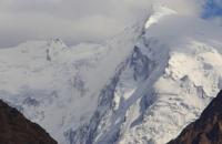
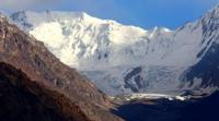
Photos of Pamir glaciers.
An alpine country adjoining in the southwest with the mountain systems of the Hindu Kush and Karakoram, in the north with the ridges of Gissar-Alai, and in the east with Kunlun, is called the Pamir. In the east, the Kashgar Mountains with the peaks of Kongur 7719 meters above sea level and Muztag 7546 meters above sea level, located in China, belong to the Pamir.
Within the Pamirs, peaks of seven thousand meters rise: Communism peak 7495 meters above sea level, Lenin peak 7134 meters above sea level, Korzhenevskaya peak 7105 meters above sea level and many peaks above 6000 meters above sea level.
he Pamir has a complex geological structure. A variety of rocks, from Precambrian to Neogene (gneisses, crystalline schists, marbles, sandstones, shales, etc.), are collected in complex folds and form a series of wide arcs facing the peaks to the north.
Their tectonic basis was laid back in the Varis and Cimmerian epochs of mountain building, but they finally formed in the era of alpine orogenesis. Mountain-forming processes, accompanied by large gaps and overthrusts, continue at the present time - the Pamir ridges are experiencing intense uplift, and depressions at their feet continue to sink.
The result is a high seismicity of the territory (up to 7 - 9 points). The Pamir mountain country is a system of powerful latitudinal strike ridges, divided in the west by deep narrow valleys, merging in the east into a single massif of the Eastern Pamirs with wide valleys and drainless hollows at heights of about 4000 m, above which the mid-mountain type ridges rise.
The northern border ridge of the Pamirs is the Zaalai Range, which rises with a giant wall over the Alai Valley, with Lenin Peak 7134 meters above sea level, in its central part. To the south from Zaalaysky range. the meridional ridges of the Academy of Sciences extend with a peak of Communism of 7495 meters above sea level and Zulumart with heights of up to 6000 - 6400 meters above sea level, which are large centers of modern glaciation.
East of the ridge. Zulumart is located drainage basin of Karakul Lake, bounded in the east by the Sarykol Range. The ridge of the Academy of Sciences connects the eastern ends of the ridges of Peter I, Darvaz, Vanh and Yazgulem.
Here many peaks rise above 6000 meters above sea level. To the south extend mountain ranges of latitudinal strike Muzkol, Rushan, Nothetn-Alichur, Vakhan, and along the middle course of the Pyanj River - the meridional Ishkashim ridge.
The climatic conditions for the existence of glaciers in the Pamirs, as in other mountain systems of Central Asia, are determined by its position in the center of the continent, the circulation of high atmospheric layers, the height and ruggedness of the mountains, intercepting precipitation from moisture-bearing air masses.
Since the Pamir is in the zone of western transport of air masses that bring moisture from the Atlantic, there is more rainfall in the Western Pamir than in the East, shielded by giant mountain ranges from the west and north.
Accordingly, the level of the nutrition boundary changes. It falls the lowest in the western and northern parts of the Pamirs to 3600 - 3800 meters above sea level), lies at a height of 4000 - 5000 meters above sea level, in the Central Pamirs and reaches a maximum height in the Eastern Pamirs of 5000 - 5500 meters above sea level.
There are 6729 glaciers in the Pamirs with a total area of 7,493.4 square kilometers .. Although more than 80% of all glaciers are up to 1.1 km in size. sq. and less, they make up only 21% of the total area of glaciation in the Pamirs. 54% of the area of glaciation falls on glaciers ranging in size from 1.1 to 25 km2. and the fourth part of the entire area of glaciation in the Pamirs is 25 glaciers larger than 25 km2 Within the Pamirs, the nature of glaciation and its size vary greatly from west to east.
In the extreme west of the Pamirs, where the height of the mountains is low, glaciers occupy the upper valleys and punches on the slopes in the range of only 200 - 300 m vertically. Small glaciers prevail here - caravan and small valley glaciers, gradually alternating to the east with larger valley and complex valley glaciers.
Accumulation on glaciers exceeds 200 g / cm2, and sometimes reaches 300 g / cm2 per year. During the ablation period, the melting of snow and ice does not significantly only in glacial languages, but also in firn areas.
Firn and warm firn types of ice formation prevail. In the Central Pamirs, where the mountains reach very high altitudes and are deeply dissected, the conditions for the existence of glaciers are most favorable. All types of mountain glaciers are widespread here, but the bulk are large dendritic and complex valley glaciers.
Their vertical range is huge (up to 3000 - 4000 m, more than 1000 m on average): starting from the highest mountain peaks and dividing ridges, they descend into deep valleys below the upper border of the forest (up to 2600 - 3000 m). Snow accumulation in firn areas of glaciers is 150 - 200 g/cm2 per year.
The main type of ice formation is cold firn, and at the highest peaks (the peak of Communism), where there is practically no melting, it is snowy. On low descending tongues of large glaciers, 8 - 10 m of ice per year melts.
The large amounts of accumulation of atmospheric precipitation in firn regions and the intense melting in glacial tongues lead to high glaciation energy and high speed of ice movement (up to 100 - 300 m/year). The speed of ice movement during the movements of pulsating glaciers, often found in the Pamirs, can reach several kilometers per year, and for short time intervals - up to 100 m/day.
Glaciers do a great geological work, carrying out a huge mass of stone material falling on their surface from the slopes of the valleys, and plowing their bed during the movement. In almost all complex valley and dendritic glaciers below the feeding boundary, ridges are clearly visible
middle and lateral moraines, which at the ends of glacial tongues merge into a continuous cloak of the surface moraine. On the Fedchenko Glacier, distinct moraines extend for many kilometers.
Authority:
"Glaciers." L.D. Dolgushin, G.B. Osipova. Series "Nature of the world." Moscow, the publishing house "Thought". 1989.
Photos
Alexander Petrov.