


![]()
Вы здесь
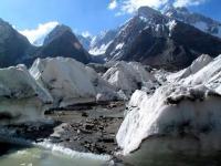
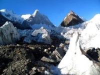
Glaciers of Tajikistan.


Tours in the mountains of Tajikistan.
“I now realized that the surest way to find out if you like a person or not is to travel with him”
Mark Twain.
Mountain routes of Tajikistan.
Currently, there are 8,492 glaciers in the republic with a total area of 8,476 square kilometers. The total volume of all glaciers is 567 kilometers cubic. Therefore, although the Republic of Tajikistan occupies about a tenth of the total area of Central Asia, almost two thirds of the runoff of the entire region is formed on its territory.
Glaciers of Tajikistan produce annually more than 13 kilometers of cubic water - almost a quarter of the total river flow of Tajikistan. Glaciers are not only accumulators, but also moisture regulators: they soften fluctuations in river flow, lower the coefficient of variation in flow, which is favorable for all sectors of the economy of the republic.
In neighboring Uzbekistan there are very few glaciers, and in Kyrgyzstan the water of the largest glaciers goes abroad, to China. The distribution of glaciers over the territory of individual basins depends on the exposure of the slopes.
The northern slopes, which receive less solar radiation, have better conditions for the development and existence of glaciers. So, in all basins the number of glaciers on the slopes of the northern directions (north, northeast, northwest) is 65 - 70% of the number of all glaciers.
On the slopes of the southern directions, the share of glaciers is only 15 - 20%. The same ratio is observed in the area of glaciation. Morphological types of glaciers are very diverse and are due to the relief, orography, climatic and other factors.
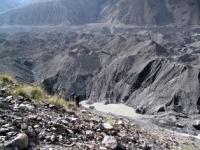
The largest, largest, glacial glaciers comprise one third of all glaciers, and two thirds of glaciation occupy the area. Glaciers descend the lowest, and the height difference between the source and the end of the glacier is greatest.
Glaciers of this type are located in the Obihingou, Muksu, Vanch, Yazgulem, Bartang, Markansu and the Karakul Lake basins. Caravan glaciers also occupy one third of the total number of glaciers, but only 10% of glaciation in area.
These glaciers are most characteristic of the marginal glaciation regions. For example, in the Surkhob and Kafirnigan basins, their number reaches 40-50% of all glaciers. Hanging glaciers are located at high altitudes, but have small dimensions, usually 0.2 - 0.3 square kilometers. In the Muksu, Bartang, Murghab and Gunt basins, they make up 1/3 of all glaciers.
Slope glaciers are continuous cover on relatively gentle slopes. They are most characteristic of the Eastern Pamirs. Their sizes are from 0.4 - 0.6 to 3 - 4 square kilometers. Thus, two-thirds of the glaciation area is occupied by large glaciers - valley glaciers, and one third - by small glaciers: cirque, hanging, and sloping.
These features are very important in calculating the degradation of glaciation due to expected climate warming. The area of the "average" glacier in Tajikistan is approximately one square kilometer. Such glaciers with an area of up to 1 square kilometer, make up 80% of the total number of glaciers and occupy only 15% of the area of glaciation.
The size of the “middle” glacier is increasing from west to east, reaching maximum sizes in the Muksu basin. In the Kafirnigan basin, they have a minimum value of 0.32 square kilometers, increasing in the Surkhob and Obihingou basins to 0.59 and 0.94 square kilometers.
To the south-east of the Muksu basin, the size of the “average” glacier decreases in the Vancha and Yazgulem basins to 1.2 square kilometers, Bartang to 1.1 square kilometers, Gunta - 0.47 square kilometers. In the Eastern Pamirs, the area of the “average” glacier is 1.1 kilometers square.
Glaciers with an area of less than 1 square kilometer have an ice thickness of 50-60 meters, therefore, in the event of climate warming, they will first degrade and disappear. The largest glaciation site in Tajikistan is located in the northwest of the Pamirs, where the ridges of the Academy of Sciences, Darvaz, Peter the Great, Vanch and Yazgulem meet, where two of the three thousand-thousanders of our country are located - I.
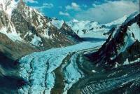
Somoni peak with a height of 7495 meters above sea level and peak E. Korzhenevskoy height of 7105 meters above sea level. Here is the largest in Central Asia and one of the largest mountain glaciers in the world - Fedchenko.
Its system includes more than a hundred glaciers. In the same area, there is the Grumm-Grzhimailo glacier with an area of 142.9 kilometers square and the Garmo Glacier with an area of 114.6 kilometers square, as well as hundreds of smaller glaciers.
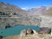
The Vanch, Yazgulem, and Bartang rivers starting at this node belong to the Pyanj basin, and the Muksu river to the Vakhsh basin. The second major glaciation site is located at the junction of the Zaalaysky and Zulumart ridges in the area of Lenin peak 7134 meters high above sea level.
The three large glaciers located here belong to different basins. The Oktyabrsky Glacier (88.2 kilometers square) gives its runoff to Karakul Lake, the Great Saukdara Glacier (53.0 kilometers square) belongs to the Muksu Basin, and the Uysu Glacier (49.9 kilometers square) belongs to the Markansu Basin.
The area of these two glaciation nodes is about 5,000 square kilometers. The upper glaciation site, although significantly inferior to the first two, can be considered the upper reaches of the Zeravshan River. Here at the junction of the ranges of Turkestan and Zerafshan there is a large complex-valley glacier Zeravshan.
Its length is 27.8 km, an area of 132.6 kilometers square, a volume of 15.85 kilometers cubic. Its tributaries also have significant dimensions. So, the length of the Rama glacier is 8.9 km, an area of 22.8 kilometers square, a volume of 1.58 kilometers cubic.
Glavtadzhikhydromet (former Republican Department of Hydrometeorological Services), began systematic observations of the glaciers of Tajikistan in 1957. Observations covered about three dozen glaciers from the Zeravshan basin to the Eastern Pamirs.
At first, only a topographic survey of the ends of the glaciers was carried out to determine whether they were retreating or advancing. Then began to level the transverse profiles. Since 1961, comprehensive glaciological and hydrometeorological observations were developed on various glaciers.
In 1961 - 1963. on the Medvezhy glacier in the headwaters of Vancha, in 1966 - on the Diakhandara glacier in the Karatag basin. A very large amount of work was performed in 1969 - 1974. on the Skogach glacier in the Obihingou basin, in 1968, 1971, 1973 - 1976 on the GGP glacier in the Zeravshan basin, in 1976 - 1978 in the upper reaches of the Fedchenko Glacier, in 1982 - 1984 - on the Dihadang Glacier. When in the 1960s, scientists from the Institute of Geography of the USSR Academy of Sciences began preparing the Atlas of Glaciers of the USSR and began studying glaciers in Tajikistan, specialists from the Republican Hydrometeorological Office took part in this.
Especially a lot of work was done in 1969 - 1972, when hundreds of glaciers were examined in the Obihingou and Surkhob river basins. Specialists of the Republican Hydrometeorological Service observed the Medvezhy glacier during its movements in 1963, 1973, 1989 and 2001, and observed the pulsating Didal glacier in 1974 - 1975.
Currently, despite the difficulties, they continue to observe the Medvezhy glacier, the Yakarcha glacier and others. Two main conditions are necessary for the occurrence of glaciation: a decrease in air temperature on such a scale that snow becomes the main form of precipitation and does not melt over the summer, moreover, it must fall in large quantities and for a long time so that ice forms from deep condensed snow.
However, the causes of the cold snap, which led to glaciation, have not been fully elucidated; various hypotheses exist on this score. The oldest known, the so-called Tupchak glaciation, occurred in the second half of the early Quaternary (over 200 thousand years ago).
It occupied a total of 29,570 square kilometers, that is, 3.5 times more than at present. The snow line was located 500 meters lower than now. The glaciation of the Eastern Pamirs was especially developed; it exceeded the modern one eight times.
In the Western Pamirs, valley glaciers along the tributaries of Vancha, Yazgulem, Bartang, and Gunta were widely developed. In its upper reaches, the glaciation of these rivers merged with the glaciation of the Eastern Pamirs.
However, in the Gissar-Alai mountains, glaciers covered only a few areas, there were almost no glaciers on the northern slope of the Turkestan Range, and there were no glaciers in the upper reaches of the Varzob River. Evidence of this glaciation has been preserved in the form of ancient moraines, cars, trogs, glacial deposits.
The second, the so-called Lyakhsh glacial era, refers to the second half of the middle Quaternary. This glaciation occurred 100,000 years ago and covered the entire mountainous territory of Tajikistan. Its area was 24,860 square kilometers, or 2.9 more than the present.
Compared to Tupchak, the glaciation of the Eastern Pamir has almost halved, but the glaciers of the Western Pamir have increased, and the glaciation of the Gissar-Alai in area is three times the present. The ancient right glacier Fedchenko (Muksuisky) occupied the entire valley of the Muksu River, reaching the tract Lyakhsh, which is why the ice age got its name.
From Lyakhsh glaciation even more traces survived than from Tupchak. These are ancient moraines, terraces, cars, troughs, glacial deposits, smooth rocks, etc. geological point of view is relatively short, not more than a few centuries.
So in Europe, cooling periods were observed in the VIII - X and XV - XIX centuries. Unfortunately, for Tajikistan and for all of Central Asia, detailed information is not available. But since changes in atmospheric circulation cover the entire planet, it can be assumed that our glaciers retreated unevenly.
The end of the th century was relatively cold, but the first half of the XXth century turned out to be very warm, the degradation of glaciers was very intense. In the 1960s and 1970s, the average temperature dropped slightly, degradation slowed down, some glaciers even began to advance in the Austrian Alps, but this did not last very long.
In Tajikistan, several glaciers (Mushketova in the Muksu basin, RGO in the Vancha basin, and others) also attacked for some time, but only slightly. The remaining glaciers retreated, their length was reduced, the surface was lowered.
In the XXth century, glacier ablation across the planet increased by an average of 12 cubic kilometers per year. From the end of the 19th century to the middle of the 20th century, melt runoff increased by 10%. From 1884 to 1975, the planet’s mountain glaciation decreased by 5%, the annual runoff from all glaciers was 403 kilometers cubic, which is 23 kilometers more than atmospheric precipitation.
Modern climatic conditions are unfavorable for the existence of glaciers, since the flow rate is greater than the arrival, ablation prevails over accumulation. The usual speed of movement of glaciers is from a few centimeters to several tens of centimeters per day.
However, there is a group of glaciers that sometimes sharply increase their speed, begin to increase in length, causing natural phenomena such as the formation and breakthrough of dammed lakes or ice collapses.
Of the sixty-five such glaciers, as they are called, of glaciers located in the mountains of Central Asia, thirty-five are located in Tajikistan, in the basins of the Vanch, 0 Bihingou, Sauksai, Surkhob, Muksu and others.
Authority:
"Glaciers of Tajikistan." General Directorate for Hydrometeorology and Environmental Monitoring of the Ministry of Nature Protection. Dushanbe, 2003.