


![]()
Вы здесь
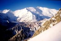
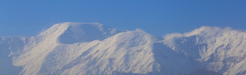
Glaciers of Zaalasky Range.

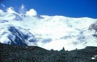
Nature is mountain of Zaalaysky Range.
“I address you all tonight for who you truly are: wizards, mermaids, travelers, adventurers, and magicians. You are the true dreamers”
Brian Selznick.
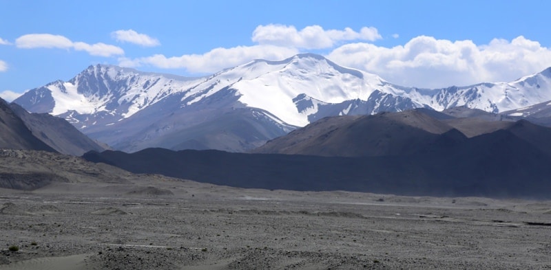
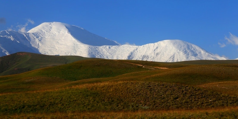
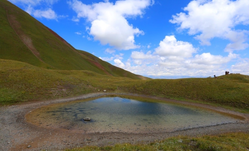
Sights of Zaalaysky ridge.
The Zaalasky ridge stretches from west to east, from the confluence of the Muksu and Kyzylsu rivers to the peak Otchaylo 5820 meters above sea level on the border with China. The average height of the ridge is 5500 meters above sea level, the highest point is Lenin Peak 7134 meters above sea level.
The Zaalai Range stretches for 240 kilometers along the Kyzyl-Suu River, framing the Alai Valley from the south. Alpine terrain prevails. The Ters-Agar passes 3,613 meters above sea level and Kyzyl-Art 4,280 meters above sea level are divided into three parts: the western (about 40 peaks, more than 5,000 meters above sea level, the highest point of Sat peak is 5,900 meters above sea level, the central one, with more than 30 peaks higher than 5000 meters above sea level, about 20 peaks 6000 meters above sea level, including the highest point of the entire ridge Lenin Peak 7134 meters above sea level, the eastern, highest point - Kurumdy Peak 6610 high meters above sea level.
Depth of calculation The relief varies from 800 to 2000 meters in the central part.The northern slope of the ridge is more gentle, the length of the river valleys is from 20 to 40 kilometers, the length of the valleys is from 8 to 20 kilometers on the southern slope.
The most significant spurs are the Ice Cape (35 km long) and Ui-Suu (25 kilometers long). The Zulumart ridge adjoins from the south. The height of the snow line is 3900 - 5100 meters above sea level. In the lower part, the slopes are covered with mountain-steppe and mountain-meadow vegetation, above - snow and glaciers.
The huge height and monolithicity of the ridge determine the powerful modern glaciation. A strip of firn fields feeding large glaciers stretches along the entire axial part of the ridge along both its slopes, interrupting only in the areas of the Tersagar and Kyzylart passes.
These passes divide the ridge into three parts: western, central and eastern, differing from each other in the nature of the relief and glaciation. The most significant is the glaciation of the central part of the ridge, where the largest glaciers of the Zaalai ridge - Lenin, Korzhenevsky, Oktyabrsky, Bolshoi Saukdara and others flow from the massif of the Lenin peak in all directions.
The northern slope of the Zaalai ridge, rising above the Alai valley, receives more precipitation than the southern, for due to moist air masses penetrating here along the Surkhob-Kyzylsu river valley. The height of the firn line on the northern slope increases from west to east from 4200 to 4500 meters above sea level, on the southern slope it is much higher - from 4500 to 5400 meters above sea level.
In total, 550 glaciers with a total area of 1329.3 square kilometers on the Zaalaysky ridge.
The western section of the 64-kilometer ridge stretches from the confluence of the Muksu and Kyzylsu rivers to the Tersagar pass. Its average altitude is 5100 meters above sea level, the highest point is Sat Peak 5900 meters above sea level on the southern spur of the ridge.
The northern slope facing the Alai Valley is wide and gentle, there are no deep valleys, nor high spurs. South is steep and rocky. Its valleys have the character of hanging troughs, steeply terminating towards the Muksu River.
There are 135 glaciers on this section of the ridge, their area is 222 square kilometers. 44 of them are glaciers An area of 94.6 kilometers square is located on the northern slope, the rest on the southern. The most common are valley and caravan glaciers.
The eastern section of the Zaalaysky ridge 30 kilometers long from the Kyzylart pass to Otchaylo peak has an average height of 5500 meters above sea level, the maximum - 6610 meters above sea level - the peak of Kurumdy.
There are 81 glaciers on this site with a total area of 303.6 square kilometers. 45 glaciers with an area of 240.1 square kilometers are located on the northern slope of the ridge. There are 8 glaciers larger than 5 square kilometers.
The largest are the Kyzyl Su and Nura glaciers. Due to the high dryness of the air, the area of glaciation on the southern slope of this section is much smaller than on the northern (36 glaciers with an area of 63.5 square kilometers).
The firn line rises here to 5200 - 5500 meters above sea level. 35% of the area falls on the Kurumdy glacier, located in a valley protected from the influence of dry and hot winds of the Tarim Depression by the southwestern spur of the Zaalai Range.
Two large streams go down the narrow and deep valleys to the south. Their tongues are broken by cracks and have icefalls in the upper parts. After the confluence of these flows, the glacier turns west, filling the entire bottom of the valley from side to side to an altitude of 4480 meters above sea level.
Below the active end of the tongue lies a field of dead ice with an area of about 3 square kilometers. Here comes the end of the glacier, formerly a tributary of the Kurumdy glacier, but now separated from it the channel of the river.
The surface of dead ice is dissected by waterways, dips, covered with lakes. There are about 40 passes in the Zaalaysky ridge from 4750 to 6200 meters above sea level. In the northern spurs about 40 passes. There are more than 20 passes in the southern spurs.
The simplest ways of crossing the ridge through the Derang, Ters-Agar, Kyzyl-Art (highway), Kyzyl-Köl, Koorganda passes. Climbing routes are known for 72 peaks. The main approaches are from the north from the valley of the Kyzyl-Suu river, where the road passes, from the south from the valleys of the Karadzhilga and Uy-Suu rivers, access to the East Pamir highway is possible along the Crimea, as well as from the valleys of the Muksu, Sauksai and Saukdara rivers , where in the western part of the Muksu river valley passes a highway, and above caravan paths.
The glaciation area of the Zaalaysky ridge is 1436 square kilometers.
The largest glaciers of the Zaalaysky ridge.
21.5 kilometers long Korzhenevsky Glacier, an area of 39.4 square kilometers, located at an altitude of 3890 to 6210 meters above sea level, belongs to the basin of the Dzhaanaydartak and Kyzylagyn rivers.
The Bolshoi Saukdara Glacier, with a length of 20.6 kilometers, an area of 53.0 square kilometers, is located at an altitude of 4240 to 7120 meters above sea level, belongs to the Sauksai river basin.
The Oktyabrsky Glacier, with a length of 19.0 kilometers, an area of 88.2 square kilometers, is located at an altitude of 4440 to 6780 meters above sea level, belongs to the Koksay River Basin.
The Dzerzhinsky Glacier with a length of 14.9 kilometers, an area of 19.0 square kilometers, located at an altitude of 4130 to 6710 meters above sea level, belongs to the basin of the tributary of the Sayuksai River.
The Kuzgun Glacier, with a length of 14.7 kilometers, an area of 25.0 square kilometers, located at an altitude of 3980 to 4020 meters above sea level, belongs to the Kuzgun-Teke river basin.
The Uy-Suu Glacier is 13.8 kilometers long, with an area of 49.9 square kilometers, located at an altitude of 4390 to 6,600 meters above sea level, belongs to the Uy-Suu River Basin.
Lenin Glacier with a length of 13.5 kilometers, an area of 55.3 square kilometers, located at an altitude of 3760 to 7000 meters above sea level, belongs to the Achik-Tash river basin.
Glacier 91 - 96 with a length of 13.4 kilometers, an area of 31.3 square kilometers, located at an altitude of 4480 to 6500 meters above sea level, belongs to the Kurumdy river basin.
The Kyzyl-Suu glacier is 13.3 kilometers long, an area of 22.5 square kilometers, located at an altitude of 3200 to 5830 meters above sea level, belongs to the basin of the tributary of the Kyzyl-Suu River.
The Koman Glacier with a length of 12.0 kilometers, an area of 27.0 square kilometers, located at an altitude of 3700 to 6700 meters above sea level, belongs to the ComanSuu river basin.
The Pravyi Kichke-Suu Glacier, with a length of 11.3 kilometers, an area of 22.5 square kilometers, located at an altitude of 3,700 to 6,280 meters above sea level, belongs to the Kichke-Suu River tributary basin.
Krasin Glacier with a length of 10.0 kilometers, an area of 14.0 square kilometers, located at an altitude of 4400 to 6710 meters above sea level, belongs to the basin of the tributary of the Kazgun River.
Glaciers 36 and 37 with a length of 10.0 kilometers, an area of 10.4 square kilometers, located at an altitude of 4470 to 5650 meters above sea level, belongs to the basin of a tributary of the Uy-Suu River.
The Chakman-Tash Glacier is 9.8 kilometers long, with an area of 14.3 square kilometers, located at an altitude of 4000 to 5710 meters above sea level, belongs to the Chakman-Tash River Basin.
Glacier 88 and 89, with a length of 9.0 kilometers, an area of 10.9 square kilometers, located at an altitude of 4440 to 6400 meters above sea level, belongs to the basin of the tributary of the Kurumdy River.
8.3 km of Achik-Suu glaciers, an area of 10.0 square kilometers, located at an altitude of 3700 to 5680 meters above sea level, belongs to the Achik-Suu river basin.
The Minzhar Glacier, with a length of 8.0 kilometers, an area of 10.2 square kilometers, located at an altitude of 3680 to 5850 meters above sea level, belongs to the Minzhar River Basin
The Atjailau-1 Glacier, with a length of 7.7 kilometers, an area of 7.4 square kilometers, located at an altitude of 4,200 to 6,000 meters above sea level, belongs to the tributary of the Atjailau and Kyzyl-Art rivers.
Kungyr-Suu glaciers with a length of 7.6 kilometers, an area of 12.4 square kilometers, located at an altitude of 3640 to 5840 meters above sea level, belongs to the Kugshyr-Suu river basin
The Vali Glacier, with a length of 7.6 kilometers, an area of 11.9 square kilometers, located at an altitude of 4000 to 5490 meters above sea level, belongs to the basin of a tributary of the Sauksai River.
Glacier 119 with a length of 7.6 kilometers, an area of 11.0 square kilometers, located at an altitude of 3760 to 5540 meters above sea level, belongs to the basin of a tributary of the Surkhangau River.
Glaciers 82 - 85, with a length of 7.6 kilometers, an area of 9.9 square kilometers, located at an altitude of 4420 to 6100 meters above sea level, belongs to the basin of the tributary of the Kurumdy River.
Authority:
"Glaciers." L.D. Dolgushin, G.B. Osipova. Series "Nature of the world." Moscow, the publishing house "Thought". 1989.
Photos by
Alexander Petrov.