


![]()
Вы здесь
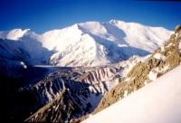
Lenin Peak is northernmost seven-thousander of Pamir.
Tours in Kyrgyzstan.
“I like geography best, he said, because your mountains & rivers know the secret. Pay no attention to boundaries”
Brian Andreas. «Story People: Selected Stories & Drawings of Brian Andreas».
Traveling in Kyrgyzstan.
Lenin Peak, 7134 meters above sea level, is located in the central part, in the main ridge of the Zaalai Range in the northeastern Pamirs, in the Chon-Alai region of the Osh region of the Kyrgyz Republic and in the Murgab region of the Gorno-Badakhshan region of Tajikistan.
The northern slopes of Lenin Peak are located on the territory of the Kyrgyz Republic, the southern slopes are on the territory of Tajikistan, the state border passes along the ridge. The Trans-Alay Range, in the central part of which is its highest point - Lenin Peak, forms the northern border of the Pamirs.
This ridge stretches in the latitudinal direction for 222 kilometers and borders in the east on the southern spurs of the Alai Range. In the west it borders on the eastern slopes of the Peter the Great Ridge and the southern slopes of the Alai Range.
The border in the west is the confluence of the Muksu and Kyzylsu rivers. The northern slope of the ridge faces the Alai valley, the southern slope faces the northern slopes of the Saukdara and Zulmart ridges and the Markansu valley.
For a considerable distance, the average heights of the Zaalai Range exceed 6000 meters above sea level. The northern slopes of the Zaalai Range for 144 kilometers are located in the Alai Valley (“Alai” from the Kyrgyz - “Paradise”).
From the foot of this ridge, between the foothills of both ranges, the valley widens from 8 to 10 to 20 to 22 kilometers. The area of the Alai Valley is 1800 square kilometers. The extreme, western lower part of the Alai Valley lies at an altitude of 2362 meters above sea level near the village of Katta-Karamyk.
The extreme, eastern part of the valley lies at an altitude of 2913.8 meters above sea level at the confluence of the Kyzyl-Suu River in Koksu. In the extreme east of the ridge, at the headwaters of the rivers from the north of Kyzylsu, from the south of Kurumda, rises the trapezoid peak Zarya Vostok, 5897.5 meters high above sea level.
To the south-west of the peak of the Zarya Vostok there is a huge snow massif of Kurumdy with a height of 6613.5 meters above sea level - translated into Russian as "visible". At the headwaters of the Kichkesu River, in the upper reaches of the Pogranichnikov glacier, the Pogranichnik peak rises 5437.9 meters above sea level.
To the south-west of the Pogranichnik peak is Arkhar peak, 5288.5 meters above sea level. 12 kilometers southwest of the Border Guard is the Kyzylart Pass, 4336 meters above sea level. The Pamir Highway passes through the pass, connecting the Kyrgyz city of Osh with Khorog in the Gorno-Badakhshan Autonomous Region.
Even to the east and southeast of the Pamir Highway runs a road from the village of Sary-Tash through the Irkeshtam checkpoint located at an altitude of 2846.7 meters above sea level, on the right bank of the Nura River.
The distance from the village of Sary-Tash to the Irkeshtam checkpoint is 70 kilometers. From here the road leads to one of the major cities of the Xinjiang Uygur Autonomous Region, in the north of the Republic of China, the city of Kashgar.
The Zaalai Range ends here and the Nura River Valley is a watershed with the border ridge Terekty-Too in the east. To the west of the Pamir Highway and to the southwest of the Bordobo checkpoint, beyond the Dzhanaidar River, there is the Ice Cape ridge with a dominant height of 5459.3 meters above sea level.
East of Marshal Zhukov peak, south of the Korzhnevsky glacier and north of the Oktyabrsky glacier Barricades Ridge is located. The ridge is part of the Zaalai Range with a length of 4 kilometers. The massif of the Korzhenevsky peak with a height of 6038.5 meters above sea level is located in front of the Kyzyl-Art river valley, which is located to the east. In the southwest, 7.2 kilometers from the Korzhenevsky peak at the head of the Uysu glacier, there is a giant peak Kyzylagyn (Red Stream) with a height of 6683.3 meters above sea level.
To the west of Lenin Peak there are three, almost identical in shape, but different in height, peaks. Dzerzhinsky Peak, 6717 meters above sea level, is located 8 kilometers west of Lenin Peak. Krasin Peak, 5999 meters above sea level, is located 11.5 kilometers northwest of Lenin Peak.
Tsuryupa Peak, 5649 meters above sea level, is located 14.6 kilometers northwest of Lenin Peak. The last pointed peak of the western part of the Zaalai Range, rising in the form of a regular trapezoid, is Sverdlov Peak, 5451 meters above sea level.
Behind the Sverdlov Peak, the Zaalai Range is divided by the valley of the Altyn-Dara River. Here, on the western slope of the ridge, there is the Kek-Chukur peak, 5184.8 meters above sea level. In the upper reaches of the Altyn-Dara River, there is the Ters-Agar Pass, 3598 meters above sea level, which is a watershed with the Ter-Agar-Suu River belonging to the Muksu basin.
To the west of the Ters-Agar pass, the Zaalai Range continues with a still powerful uplift with heights of more than 5000 meters above sea level. At the western end of the ridge, the Kyzylsu River, which flows through the Alai Valley and originates from the northeastern slopes of the Zaalai Range, merges with the Muksu River at an altitude of 1834.2 meters above sea level.
Muksu originates from the upper reaches of the Fedchenko glacier and the southern slopes of the Zaalai Range. After the confluence of the two rivers, the Surkhob River, which belongs to the Vakhsh basin, is formed.
The modern glaciation of the Zaalai Range is very significant and comes after such large glacial centers as Fedchenko (Pamir) and Inylchek (Tien Shan). The weak dissection of the ridge and the huge absolute height led to a powerful modern glaciation.
Lenin Peak serves as the center from which the largest glaciers of the Zaalai Range spread in all directions, forming the main node of modern glaciation. In the glaciers and snowfields of the Alai and Zaalai ranges, streams originate, which merge with the Kyzylsu River, which flows through the Alai Valley. Behind the Taukmurun range are the sources of another river of the same name. This river - Kyzylsu (Eastern) - flows to the Republic of China.
Сlimate of Lenin Peak.
The climate of Lenin Peak is characterized by sharp contrasts. In the lower part it is moderate, and in the highland zone it takes on severe polar features. Summers are short, cool and even cold. Last from June to August.
In the highlands, summer warming penetrates with a significant delay, therefore, in the upper parts of the ridge, the warmest month is August, while in the Alai Valley - July. Temperature fluctuations, both annual and daily, are very significant. In the hottest time of the year, they can reach +5° during the day and up to -30° at night.
A warm day with intense solar radiation is usually replaced by a cold one, with frosts at night. And even during the day, a negative temperature is often observed in the shade, while on the sunny side it is + 15 - 20 °. The temperature of the air with increasing height above sea level drops by 0.5 - 0.6 ° for every 100 meters.
The prevailing winds are southwest and west. In the daytime, the wind speed reaches, on average, 6 - 8 m / s, at night it decreases to 2 - 4 m / s and then fades to complete calm. Gusty, squall winds with snow (speed of 15 m/sec or more) sometimes blow up quite unexpectedly. This phenomenon is usually observed during the daytime.
On the crest of the Zaalai Range, there is a special density of the firn, which is caused by hurricane-force winds of the western direction. As many climbers noted, on the western and eastern ridges of Lenin Peak, starting from an altitude of 6200 - 6500 meters above sea level, hurricane-force winds are very often observed.
They often tear down tents, sweep snow from a wide ridge. The eastern slopes of the meridional spurs of the Zaalai Range are more snowy due to snowstorms and transport, and therefore they pose a great danger of avalanches. Snow cornices most often hang in this direction.
Cloudiness due to the dryness of the air is usually negligible. The clearest period is August. The number of days with precipitation in July is greater than in August. In the first month of autumn - September - there is also a period of stable, but relatively cold weather.
As a rule, at the end of August the weather deteriorates, snow falls. Then, towards the middle of September, clear weather sets in again, which lasts for about two weeks. As it rises, cloudiness and precipitation increases sharply, reaching a maximum at an altitude of 3500 - 4000 meters above sea level.
On the northern slope of the Zaalai Range, especially in the region of the highest peaks, there is more precipitation than on the southern one. The boundary of eternal snow in the Zalaysky ridge lies on the northern slope at an altitude of 4500, on the southern - 5000 meters above sea level.
Fogs, thunderstorms, hail are relatively rare. In the region of glacial tongues - this is especially noticeable near the tongue of the Oktyabrsky glacier - strong winds begin every day after 2 pm. Streams of cold air from the crest of the Zaalai Range rush down the gorges.
On the ridges leading to the summit, very often there are drifting snows and strong storm gusts that can tear and demolish poorly fortified tents. Based on long-term data, the first half of August should be considered the most favorable time for climbing Lenin Peak.
But, despite the prevailing good weather, there can be long, lasting up to 4 - 5 days, periods of bad weather. Atmospheric pressure at an altitude of 7134 meters above sea level is 290 mm Hg versus 760 mm at sea level. The snow-covered slopes of the summit are especially affected by the action of ultraviolet radiation.
Due to low humidity and the burning rays of the sun, unprotected areas of the skin, and especially the mucous membranes, dry out and crack, causing significant pain. In 1950, on the eastern ridge, approximately at an altitude of 6700 meters above sea level, outcrops of corals of the Lower Permian age were discovered, and on one of the peaks of the Achik-Tash mountains (the northern foot of the Zaalai Range), samples of the Mesozoic fauna were collected in the form of plicenodes and corals.
Samples were identified in 1951 by Doctor of Geological and Mineralogical Sciences N.P. Vasilkovsky and Candidate of Geological and Mineralogical Sciences A.G. Babaev (now Corresponding Member of the Academy of Sciences of the UzSSR).
Geographic coordinates of Lenin Peak: N39°20'51.70" E72°52'43.33"
Authority:
http://www.mountain.ru/article/article_display1.php?article_id=1240
V. I. Racek, “The Five Highest Peaks of the USSR”, Uzbekistan Publishing House, Tashkent, 1975.
Photos by
Alexander Petrov.