


![]()
Вы здесь
Traveling on roads of Pamir.
Sights of Gorno-Badakhshan region.
"When traveling, the main thing is not to forget that the meaning is in the journey itself, and not at its end. If you are in a hurry, you will miss the goal for which you are traveling"
F. Lamenne.
Nature and geography of Pamirs.
No country in the world has such a variety of natural beauties as in the Pamirs. And in this beauty parade, the Pamirs had a special place. Pamir is the highest part of Central Asia. But not only the height of the mountain peaks distinguished the Pamir from other beautiful places in the region.
It is located in Central Asia between the mountain systems of the Hindu Kush and Karakorum in the south-west, the Gissaro-Alai ridges in the north and Kunlun in the east. A caravan route from India and Western Asia to China and from India to Central Asia went through it, though not a simple one.
Caravan tracks in different parts of the Pamirs were sections of the Great Silk Road. The Pamir was a connecting link between ancient civilizations. Seeker of Buddhist manuscripts and the learned Chinese Xuan Zang, the Venetian merchant and traveler Marco Polo, the Portuguese Catholic missionary Benedict Goesh, passed through the Pamir along the ancient caravan trails.
According to legend, Alexander the Great also reached the Pamirs. Many residents of the Pamirs consider themselves descendants of his warriors. Legends gave Pamir mystery. Some thinkers placed the center of an ancient civilization there.
Others considered him the abode of the Bigfoot. Nowadays, the Pamir is relatively easily accessible. It is characterized by weather stability in the summer months. The beauty, nobility, calm majesty of the Pamirs amaze at first sight. He can not show his severity and menacingness right away - it will give time to assess the danger.
The harmony of these qualities irresistibly attracts both inexperienced youths and retired pensioners, and professional geologists, glaciologists, botanists, meteorologists, drivers, pilots, and climbers, and tourists. Many of those who visited the Pamirs were captured by his incomprehensible charm until the end of his life.
There was an expression in use: “Pamirets is a moral concept.” From afar, the central part of the Pamir can be seen if you climb the crest of the Alai ridge lying to the north of the Pamir in its middle part. This must be what Pamir saw in 1871, the first serious explorer of the mountainous part of Turkestan, Aleksey Pavlovich Fedchenko, looking “into the distance from the pass so far that it took your breath away”.
The names of the peaks visible in the frame were given later. In the center is the peak, formerly known first as the peak of Stalin, then as the peak of Communism, and now it is the peak of Ismail Samani, to the left of it is the peak of Evgenia Korzhenevskaya, and to the right is the peak of Moscow.
From the north, the Pamir is limited by the Zaalai ridge, in the latitudinal direction, whose wall stopped Fedchenko, and the Peter the Great ridge. It can be seen that almost all large ranges, with the exception of the Academy of Sciences ridge in the center of the Pamirs, running along the left side of the Fedchenko Glacier, and the Zulumart ridge along the right, have a latitudinal direction.
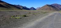
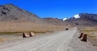
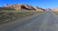
The thread of the Pamir tract Osh - Murgab - Khorog - Dushanbe goes around the Pamir from the east, south and west. This is one of the most difficult roads in the world. In ancient times, a lot of effort was spent on maintaining the track in working condition, and now it has become extremely dangerous.
Movement on it is now insignificant. Fertilizers, agricultural machinery, building materials, gasoline, equipment for high-altitude scientific stations and observatories, food, clothing are being brought. Branches from the tract made it possible to reach by car a place from which you can begin adventure and water trips.
If you start your way to the Pamir by car along the Pamir Highway from the fun and vibrant city of Osh, located on the territory of Kyrgyzstan at the eastern end of the Ferghana Valley, then, passing the low Chigirchik pass and the Gulcha river valley, we will get to the Taldyk pass 3650 m. a. s. l., through the Alai Range to the Alai Valley.
A long and tiring serpentine for drivers leads to the Taldyk pass. Descent from it leads to the village of Sarytash in the Alai Valley. Countless herds of sheep move this way to the Alai Valley in the spring, and back in the fall If you spend the night in Sarytash, then in the early invigorating morning you will feel yourself on the threshold of an unknown country.
The six-thousanders of the eastern tip of the Zaalai ridge are already lit by the sun, the peaks of Zarya Vostoka at a height of 6346 meters above sea level and Kurumdy at a height of 6555 m. a. s. l. Sarytash is a typical Kyrgyz highland village with houses of simple, unpretentious architecture.
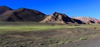
Probably, all the need for beauty among the inhabitants of such villages is satisfied by the surrounding nature, in which this beauty beyond measure. The wide Alai valley (in places more than 40 kilometers wide) goes east-west between the high Alai and Zaalaysky ridges, descending into the valley with soft grassy spurs.
During the day, the illumination of the mountain peaks covered with snow and ice and the whimsically curving spurs departing from them constantly changes, playing with an infinite number of shades. The huge sky above all this landscape, either absolutely clear, or filled with swarms of clouds piling on top of each other, now snow-white during the day, then glowing at sunset and sunrise, pours the dynamics of life into this powerful and still beauty.
From Sarytash, you can turn west from the Pamir Highway down the Alai Valley along the Kyzylsu River flowing between the Alai and Zaalai ridges to the village of Daraut-Kurgan and further west to the Surkhob Valley in Tajikistan.
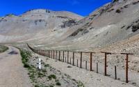
From the Alai Valley, the most attractive part for traveling and climbing is the part of the Zaalaysky Range, adjacent to its highest point - Lenin Peak, 7134 m. a. s. l. If we continue from Sarytash along the Pamir Highway to the south to the pass through the Zaalai ridge called Kyzylart, which means “red pass” in Kyrgyz, then, having climbed it, we are already in the Pamirs, or in Gorno-Badakhshan, the inhabitants of whom greeted all arrivals at the pass with an inscription cast in metal.
Pass height - 4280 m. a. s. l. From the pass, the road goes down to the Markansu River Valley, which has eastward flow to China. In the summer, its channel in the upper reaches completely dries up. No vegetation. A caravan trail has been walking through the valley since ancient times.
In the Markansu Valley, remains of bonfires from sites aged 8 to 9.5 thousand years were discovered. They burned juniper, willow in bonfires, that is, the conclusion suggests itself that juniper and willow were growing in the Markansu Valley at that time, and therefore the valley itself was at that time at a lower altitude.
Accordingly, it is possible to evaluate the growth rate of height. It turns out something about 5 - 7 cm per year. Were discovered here and tools of primitive man. And if you extrapolate to the distant past, you can imagine the Pamir as a wooded area with rivers and lakes, where many animals and birds were found, a real earthly paradise, which, perhaps, became the cradle of civilization.
And now the Markansu Valley is the most severe place on the plateau of the Eastern Pamirs. Even in the summer, the nights are always freezing. In the afternoon, a strong wind rises. Sudden dust and snow storms are possible. According to eyewitnesses, in ancient times, piles of bones and mummified corpses of pack animals that remained from caravans that once passed lay along the ancient trail.
Through the low watershed, the Pamir Highway goes to Lake Karakul, over which the Zaalaysky Ridge stands in the distance. Not far from the lake there was a border outpost - near China. The border runs along the Sarykol Range, which has a meridional direction.
If, after Lake Karakul, you turn from the Pamir Highway to the southwest to the Kokuybel River, you can get to the Tanymas River. The Tanymasa valley, sparkling in the evening with the separate arms of the river, leads up already to completely deserted places on moraines and glaciers.
To Fedchenko Glacier - the longest valley glacier in the world. To the Grumm-Grzhimailo glacier - the second largest in the Pamirs. The passage along the Tanymas River is uncomplicated. The road goes down to the Tanymas river, a serpentine that is dangerous for cars, climbing along the slope, and not every driver decides to pass it at any time.
Down the Tanymas, which after merging with the Kokuybel river forms the Kudara River, the road leads to the beginning of the Bartang River, which flows into the main Pamir River - Panj. From the Karakul Lake, the Eastern Pamir Highway takes you to the expanses of the Eastern Pamir through the highest in the CIS automobile pass Ak-Baital with an altitude of 4655 m. a. s. l.
The name Eastern Pamir has become commonplace in the eastern part of the Tajik Pamir, although further to the east on Chinese territory there is also the Chinese Pamir with a peak height greater than that of the highest peaks of the Tajik Pamir.
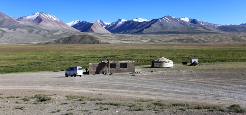
The Eastern Pamir is a plateau with a harsh sharply continental climate. In the center of the Eastern Pamirs, at an altitude of 3658 m. a. s. l., a military engineer, Staff Captain A.G. Serebrennikov from Colonel Ionov’s detachment built in 1892 an earthen redoubt with two bulk sites for Maxim machine guns.
The fortification was called the Pamir post. Now here is the village of Murgab - the capital of the Eastern Pamirs. Mostly populated by Kyrgyz. There are several hotels. There is no need to talk about their stardom. The number of tourists from Europe, Japan, USA, visiting the Eastern Pamirs, is constantly growing.
For example, the Druzhba hotel with a wonderful host - the Kyrgyz Zharkhysh-bai. They say he had 17 wives. He knows a lot and knows a lot. And to make technical inventions, and to compose poems and music for them, and to perform them himself.
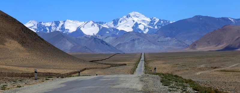
His house is decorated with photographs of the glorious Soviet past, diplomas and objects of folk art. From the village of Murgab, the Pamir Highway goes through the expanses of the Eastern Pamirs with wide and flat valleys of the Murgab and Alichur rivers and goes through the Koytezek pass 4271 m. a. s. l. into the Gunt river valley, at the confluence of which the city of Khorog, the mountain of Badakhshan, is located in the main Pamir river Pyanj.
Khorog is located at an altitude of 2200 meters above sea level. The Osh-Khorog section, 728 kilometers long, was built in 1931-1934. Another way to the Pamir is from the capital of Tajikistan, Dushanbe. The western part of the Pamir Highway, starting in Dushanbe, goes around the western end of the Peter the Great ridge and leads south from the Obihingou river valley through the Khabubrab pass 3270 m. a. s. l. into the Panj river valley.
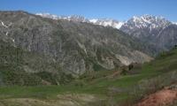
The border of Tajikistan with Afghanistan runs along it. The Western Pamir differs from the Eastern one in the sharp rugged relief with high ridges and glaciers. Stormy rivers flowing from under the glaciers have a predominant runoff from east to west to the Pyanj River, enveloping the Pamir from the south and west.
The Pamir Highway goes along Pyanj to Khorog, the capital of Gorno Badakhshan, from where there are branches to the Shahdara River basin, and also further along the Pyanj River towards the resort of Garm-Chashma and the village of Ishkashim in the South-Western Pamirs.
The 536-kilometer-long section of the Dushanbe-Khorog Pamir Highway was built with the great enthusiasm and enthusiasm of the builders for 110 days in 1940 and was then named after Stalin. The Western Pamir Highway is one of the oldest caravan routes included in the so-called Great Silk Road.
In the north of the Pamir, the Vanch River, the northernmost of the large tributaries of the Panj in the Pamirs, is most attractive for traveling to the Central Pamir. The road from Panj up the Vanch river leads first to the Vanch village, where there used to be an airfield, and the flights of the local airlines were regular.
Then the road passes east through the entire Vancha valley to the highest village of Poi Mazar and then through the bridge over the Abdukagor river, which the river often demolishes, you can reach the base of geologists - the village of Khrustalny at the tongue of the Medvezhy glacier.
Routes to the Fedchenko Glacier along the Abdukagor River and along the Glacier of the Geographical Society begin from the bridge. One of the simplest routes to the Central Pamir (excluding helicopter castings) begins from the valley of the Muksu River, flowing west from the southern side of the Zaalaysky Range.
At the confluence of the Muksu and Kyzylsu rivers, flowing along the Alai Valley, the village of Lyakhsh is located, where there is an airfield. It can also be reached by road from Dushanbe along the Surkhob river valley, which is formed from the confluence of the Muksu and Kyzylsu rivers.
This is also a section of the ancient caravan route, which was part of one of the options of the Great Silk Road. Its continuation leads to the Alai Valley and further to China. From the bridge over Muksu, behind which on the left bank of the river the Muk village is located, there is only a short section of the road to the Kandou flyover.
The left tributaries of Muksu begin from under the glaciers on the slopes of the Peter the Great ridge. Just above the bridge over Muksu, the first left tributary, the Duvanasu River, flows into it. It flows from under the relatively small Muzgazy (Oshanin) glacier, surrounded by beautiful peaks in the ridge of Peter the Great and its spurs.
The next upstream tributary of Muksu - the Shagazy River flows through a short wooded gorge. Further upstream of the Muksu, a major tributary is the Sugran River, breaking through to a narrow gap in the rocks towards Muksu. The path to the upper Sugran goes through the bridge over this canyon, at the bottom of which a furious stream roars.
The Sugran River Gorge is also wooded. In addition to the rather large Sugran glacier, runoff to the Sugran river is also provided by the glaciers Byrs, Gulchat, Shini-Bini, Nadezhda, Vera. In their upper reaches there are many relatively simple passes through the ridge of Peter the Great and its spurs.
If from the Kandou fly in front of the Sugran estuary we cross to the right bank of Muksu along a narrow pedestrian bridge, we can continue our way up Muksu to the rocky clamps along both its banks through which there are no easy passages.
Gold miners and hunters used a steel cable stretched over the river to cross the left bank. After crossing the cable and passing through the low Tomasha Pass, on which stands an amazing stone - a miracle of nature, we find ourselves in a rather wooded and secluded valley of the Khadyrsha River.
From it passes of varying complexity through the lateral spurs of the Peter the Great ridge make it possible to get into the Sugran basin and the Fortambek glacier, that is, actually in the center of the Pamirs to the peaks of Communism, Evgenia Korzhenevskaya, Moscow and to the Firnovoe plateau.


Authority:
Nikolaev A.N. "Mountain country of the Pamir."
Photos by:
Alexander Petrov.