


![]()
Вы здесь
First ascent to peak Korzhenevskaya.
Pamir expedition climbers.
“Only climbers know how much willpower and courage are needed to retreat where there is at least something that would justify an upward movement.”
Reinhold Messner.
Trip from Almaty to Pamir.
On August 22, 1953, eight climbers of the Pamir expedition of the All-Union Central Council of Trade Unions - A.S. Ugarov, A.S. Gozhev, L.M. Krasavin, P.K. Skorobogatov, B.D. Dmitriev, A.I. Kovyrkov, E.M. Ryspaev and R.M. Selidzhanov - reached the peak of Eugenia Korzhenevskaya peak at a height of 7105 meters above sea level.
Soviet high-altitude climbers defeated the last, third highest after the peaks of Lenin and Stalin, the seven thousandth Pamir, the fourth highest peak of our Soviet Motherland. This was the victorious conclusion of the struggle for the conquest of the peak of Evgenia Korzhenevskaya, which began 17 years ago and took away a lot of energy from the participants of two previous expeditions.
The peak of Eugenia Korzhenevskaya was discovered and mapped by the famous mountain researcher of Central Asia, geographer and glaciologist N.L. Korzhenevsky in 1910 Back in 1904, setting as his goal the study of the then mysterious Pamir, N.L. Korzhenevsky takes his first trip to the upper river Muksu.
At that time it was known that this powerful river, one of the sources of the high-water Vakhsh, originates in the greatest glaciers of the Pamirs. The most significant of them was discovered in 1878 by entomologist and geographer V.F. Oshanin and named him Fedchenko Glacier in honor of the famous explorer Pamir-Alai.
Narrow and deep river valley. Muksu is bounded on the north by the slopes of the Zaalai Range. To the south of it rise the snow giants of the ridge of Peter the Great, also discovered by V.F. Oshanin in 1878. By the time of the first expedition N.L. Korzhenevsky information about the orography of the ridge of Peter the Great was very scarce, and the traveler hoped to collect more complete data during his routes.
In September 1904, N.L. Korzhenevsky, along with the conductor, Kyrgyz Tokhtur-bai, emerged from the village of Altyn-Mazar in the headwaters of Muksu downstream of the river. With the greatest difficulties, they managed to go along head-spinning hiking trails through the wild gorges of the gorge of the river Muksu until its confluence with the river.
Kzylsu at the Tajik village of Damburachi. In a report on his travels, N.L. Korzhenevsky gave a detailed description of the route1, a diagram of the mouths of the right and left tributaries of Muksu, information about the traces of ancient glaciations of the basin.
Of considerable interest were his reports on the then-unknown powerful modern glaciations of the northern slopes of the Peter the Great ridge. One of these glaciers was discovered by a traveler 25 versts west of Altyn Mazar. N.L. Korzhenevsky, looking at the gorge opened on the left, drew attention to the powerful end moraines and the tongue of a large glacier approaching from the south close to the Muksu valley. According to Tohtur-bai, it was the Karasel glacier.
he researcher then limited himself to a cursory examination of the tongue of the glacier from the river. Muksu; he could not trace the continuation and examine its headwaters due to bad weather and low cloud cover. N.L. Korzhenevsky therefore hoped to explore the Karasel glacier, which he later called the Mushketov Glacier.
However, the difficulties of traveling down the Muksu valley undermined the traveler's strength, and the attempt to examine the newly discovered glacier had to be postponed for six years. In August 1910, N.L. Korzhenevsky with his companion, Dr. M.P. Bogdanov, again penetrates the upper reaches of Muksu.
August 21, they went to the language of Fedchenko glacier. The next day, it was decided, together with the conductor, Uzbek Khalmet, to attempt to inspect the Mushketov glacier from the right side of the Muksu valley; crossing to the left bank, to the tongue of the glacier, turned out to be impossible because of the high water.
Unlike the first trip, the weather was warm and sunny. Proceeding trotting on horseback, the group two hours later reached Doradek tract. There were two winters, the last traces of Kyrgyz settlements in the upper river.
Soon the horse trail broke off, and further movement became possible only on foot, along a barely noticeable path. After half an hour N.L. Korzhenevsky and Halmet were on the beam of the Mushketov glacier glacier.
Cloudless weather allowed a glimpse into the upper reaches of the glacier, and an unforgettable panorama of the spurs of the Peter the Great ridge, covered with a powerful snow-ice shell, opened up before the explorer.
“The first thing that struck me,” wrote N.L. Korzhenevsky, this giant ice mass rises in the background of the Karaselsky gorge. The flat surface of its crest was carried away by at least 20,000 f. (about 6100 m. - Ed.) in height and brightly sparkled with powerful ice, which, in all likelihood, feed the Karacel glacier.
From us this peak was about 20 versts, and one must think that glacier has approximately the same extent. I dedicate this majestic peak to Evgenia Sergeyevna Korzhenevskaya with the name of which my gratitude for heartfelt participation in my travels is woven. ”
N.L. Korzhenevsky made notches from the right bank of the river. Muksu also determined the location of the Mushketov glacier, the language of which was no more than two miles. The visible contours of the glacier, the slopes of its gorge and the peak of Korzhenevskaya were plotted on the first map of this region, attached to the report.
Comparison of information N.L. Korzhenevskogo on the location and height of the newly discovered peak with modern cartographic data shows that the original investigator in his basic definitions was close to the truth.
However, some of his assumptions about the orography of the peak region did not materialize; The assumption of a connection between the headwaters of the Mushketov Glacier through the passes with the Hingou River basin turned out to be insolvent.
These errors and the limitations of the first information about the Korzhenevskaya peak are natural. At that time, the vast spaces of the high mountains of the Pamirs, lying many tens of kilometers south of Muksu, right up to the Panj, were not yet explored and indicated on the geographical maps of Central Asia as a “white spot”.
As a result of the work of Korzhenevsky in 1904 and 1910. only a few data were obtained on the northern slopes of the giant peak; full information about the glaciers of this site, the location of the Korzhenevskaya peak and the location of its ridges could only be obtained as a result of sorties into the depths of the “white spot”.
But this work in the conditions of the tsarist system was beyond even for such a bold and persistent researcher as N.L. Korzhenevsky. It was completely possible to solve it only during the years of Soviet power to a new generation of geographers and researchers of the alpine Pamirs, who relied on the experience of their predecessors.
In 1928, the Academy of Sciences of the USSR organized the First Pamir Expedition, which set as its main task a survey of the highest ridges of the Western Pamirs, which includes the Fedchenko Glacier area. Thanks to the perseverance of the expedition teams, which included experienced climbers, it was possible to make a number of geographic discoveries. It turned out that the Fedchenko glacier extends far into the unexplored region of the Pamirs and in its length occupies one of the first places among the mountain valley valleys of the world.
The expedition of 1928 practically proved the possibility of communication of the upper reaches of Muksu through the passes of the Fedchenko glacier basin with the right tributaries of the middle reaches of the river. Panj; however, her work did not provide new information on the location of the mountains west and northwest of the ridge of the Academy of Sciences, an area that includes the area of Korzhenevskaya peak.
In 1929 and 1930, expeditions of the USSR Academy of Sciences continued the systematic exploration of the basin of the right tributary of the Muksu - the Sauksai River, originating from the southern glaciers of Lenin Peak.
In 1931, exploration of the southwestern outskirts of the “white spot” - the Sugran, Garmo, and Gando glaciers - took place. But this time, it was not possible to determine the relative position of the upper reaches of these glaciers and the region of Korzhenevskaya peak, to explain the contradiction of the data obtained earlier from observations from the east and west of the Garmo peak, which was then considered a nodal top.
The riddle of the Garmo knot was only resolved in 1932, after the results of the work of several units of the Tajik expedition of the USSR Academy of Sciences were brought together. It was found that a powerful trapezoid peak 7495 m high, the highest point of the USSR, called the Stalin peak, is located at the junction of the meridional ridge of the Academy of Sciences and the latitudinal ridge of Peter the Great.
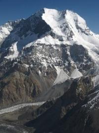
The survey found that Stalin's peak has nothing to do with Garmo peak. The expedition of 1932 also resolved the basic questions of the orography of the mountain node of the peak of Evgenia Korzhenevskaya; detachments of topographers and climbers examined the Fortambek and Mushketov glaciers, visited the upper reaches of their main tributaries, determined that the Korzhenevskaya peak was located in the northwestern spur of the Academy of Sciences ridge not far from Stalin peak; the distance between them is not much more than 13 km.
The powerful glaciation of Korzhenevskaya peak belongs to the pools of the Fortambek and Mushketov glaciers. The valleys of these glaciers and their lateral tributaries cut deep into the massive peak, forming steep, often steep slopes; height differences reach 3000 - 3500 meters.
The topographic teams of the expedition compiled the first maps of this region. The height of the peak was initially determined at 7050 m, then at 6922 meters above sea level, the most reliable geodetic measurements of recent years determine its height at 7105 meters.
Thus, Korzhenevskaya Peak turned out to be one of the highest peaks of the Soviet Union and until recently was considered its third 7000th peak. Since 1932, the conquest of this peak has become the goal of groups of high-altitude climbers.
In 1933, the first ascent to the peak of Stalin was made, in 1934 - to the peak of Lenin, Korzhenevskaya peak was in line. The possibility of climbing Korzhenevskaya peak from the basin of the Mushketov glacier seemed unlikely.
In 1932, the glacier right up to the headwaters was examined by the climber V.D., members of the Tajik expedition of the Academy of Sciences. Nedokladovym and geologist A.N. Soldatov. They reported that the slopes adjacent to the eastern and northwestern summit ridges of the peak are very steep, avalanche hazardous and attempts to climb the summit from here are hardly possible.
One should also take into account the difficulty of approaches to the language of the Mushketov glacier: the only wade to the left bank of Muksu at Doradek tract is impassable until September; approaches to the language of the Mushketov glacier on the left bank from the lower reaches of Muksu along the paths of gold prospectors are extremely difficult and hardly passable for pack transport.
The first acquaintance of climbers with the headwaters of the Fortambek Glacier in 1932 and 1933. also did not bring comforting results. It was found that the southern slopes of Korzhenevskaya peak and its southeastern ridge leading to the Four peak, abruptly break off to the head of the Moscow glacier with steep two-kilometer walls.
In September 1936, a climbing group worked in the upper reaches of the Fortambek Glacier, exploring ways to climb Stalin Peak from the north. It consisted of a trekking instructor, whose participants in July-August unsuccessfully stormed Lenin Peak.
Climbers P.N. Alhambrov, E.A. Beletsky, D.I. Gushchin, N.N.A. Gusak, A.B. Japaridze, I.G. Fedorov went to Fortambek gorge from the lower reaches of Muksu, crossing the left bank of a turbulent river along a shaky bridge at the Devsyar village.
Climbing up Fortambek Glacier, four hours from his tongue, climbers noticed a narrow gorge, not indicated on the map of the topographer, that cut through a high terrace of ancient glacial deposits on the right bank of the glacier.
The shape of the lower slopes of the gorge suggested that it could lead deep into the massif of the Korzhenevskaya peak, to one of its summit ridges. The search for the path to the top of Stalin's peak from the north, from the upper reaches of the Moskvin and Walter glaciers, was unsuccessful.
A survey was undertaken of some little-studied areas of the Fortambek Glacier Basin. ON THE. Gusak and A.B. Japaridze together decided to scout the gorge, hoping to find a path to the top of the peak. Climbers not without difficulty overcame the first steep step of the gorge, which received the name Korzhenevskaya in subsequent expeditions.
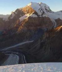
Ascent was possible only along the channel of a few-water, but turbulent stream, judging by the color of the water originating from the eternal ice. After four hours of climbing the gorge, a view of a narrow but powerful glacier, forming two steep steps in the lower part, opened up.
The of the glacier was free of stones, and its lower part lay at an altitude of 4090 meters, 1000 - 1100 meters above the level of Fortambek glacier at the entrance to the Korzhenevskaya gorge. Over the left bank of this glacier stood the sheer smooth walls of a rocky ridge, going up to the east.
From the tongue of the glacier it was possible to see part of the upper firn fields, the path to them seemed easy. Further, over the snowy saddle of the pass, steep snow slopes rose from the south and the massif of a rocky peak at least 6,000 m high blackened.
Even further, in torn clouds, the outline of a powerful snow ridge was outlined. It seemed that it leads up and east, but was it the way to the top of Korzhenevskaya peak? Gusak and Japaridze, despite the small size of the group and limited food supplies, decided to continue their journey up this glacier.
The next two days were filled with hard but exciting work; each hundred meters of climb seemed to climbers another step on the way to the goal. On the second day, climbers went to the pass, to the height of the peaks of Elbrus.
The opened east view rewarded them for the difficulties of the campaign. In the gap of the gorge lying at their feet, a powerful glacier was visible, dissected by cracks; against the background of ice, median moraines were clearly marked. It could only be the Mushketov glacier, and the huge peaks behind it belonged to the group of Altinmazar peaks.
Climbers were on the watershed ridge between the basins of the Mushketov and Fortambek glaciers. The next day, it was decided to continue the ascent from the pass along the northern slopes of the rocky six-thousander.
Climbers hit the road, hoping in the evening to return to the bivouac to a small climbing tent on a trampled place in the snow. The path went first along a clearly defined dividing ridge, and then along the snowy slopes with a steepness of 45 - 50 °, overlooking the rocks of the six-thousander. It was cold, hands and especially legs were cold (Dzhaparidze ventured to go on a high-altitude trek in ordinary, non-warmed climbing boots).
In the afternoon, climbers reached the first cliffs of the black massif (about 6200 m), which from below seemed an independent peak. In fact, it was only rocky outcrops on a buttress adjoining a powerful summit ridge eastward.
The bends of the ridge did not allow to consider its upper part, but now the scouts did not doubt that it was possible to go along this ridge to the highest point of the massif. With a strong freezing wind, climbers began their descent and reached the tent by evening.
The gander with difficulty stole the hardened boots from his companion's feet. Both feet of Japaridze’s feet were frostbite. Rubbing with snow did not help. Dzhaparidze's legs were unbearably painful, he walked slowly, leaning on the shoulder of his companion; the descent continued almost without stops for rest and sleep.
Two days later, on the Fortambek glacier, scouts met with a rescue team, which immediately began to evacuate the patient along the path along the river. Muksu to Altınmazar and further to Ferghana to meet the doctors called by radio.
Intelligence N.A. Gusak and A.B. Japaridze paved the way to the top of other groups, and already in the next, 1937 an attempt was made to storm. To commemorate the twentieth anniversary of the Great October Socialist Revolution, Soviet climbers climbed all three (then known) 7000 meters peaks: the peaks of Lenin, Stalin and Korzhenevskaya.
Three detachments of high-altitude climbers were combined in the Pamir expedition of the All-Union Council for Physical Culture and Sports. Special portable radio stations allowed the detachments and assault groups to keep in touch with each other, with the expedition base in Osh and with the airfield in the Alai Valley.
Three aircraft were selected, adapted for flights at high altitudes. It was assumed that the use of aviation will reduce the number of pack animals, speed up and facilitate the supply of climbing groups on the way to the peaks.
It was decided to deliver goods to high-altitude camps, dropping them from a shaving flight without parachutes. For the assault on Korzhenevskaya peak, climbers A.F. Getie, N.A. Golofast, D.I. Gushchin, I.V. Korzun, G.M. Prokudaev, V.S. Naumenko, radio operator N.A. Kokin and doctor V.I. Maslov.
On July 23, the detachment was transported by air to the village of Lyakhsh, at the foot of the western spurs of the Zaalai Range. It was possible to move further only with pack trails. They decided to cross the Muksa along the uppermost bridge at the Khoji-Toy kishlak, which shortened the difficult path along the left bank of the river.
July 29, the detachment crossed the Muksu. A bridge of two juniper trunks without flooring and railings swayed on unreliable coastal abutments at every step, a river raged ten meters below. The cargo was carried on hand, after which donkeys and yaks were transported with all the precautions.
The path along the left bank of the Muksu from Khoji-Toy to the Fortambek gorge crosses the gorges of the Irgai and Khadyrsha rivers. The local population has long used the river terraces and ravines of these rivers for grazing, a path was laid there crossing the coastal screes and numerous sais completely destroyed this unreliable path in several places.
Climbers spent a lot of time in order to make the trail passable for pack animals. A whole day they built a bridge over a stormy river. Khadyrsha. Then the cargo had to be carried in backpacks: Muksu’s water was flooded in some sections of the trail.
The path to Fortambek gorge took five days, and only towards the evening of August 2 the expedition members reached the Fortam ¬bek glacier language. By this time, food stocks came to an end, and the detachment switched to a reduced ration.
Only on August 6, the aircraft parachuted the necessary loads, and on August 7, climbers made reconnaissance of the route and to set up high-altitude camps. The detachment followed the route of Gusak and Japaridze. Part of the cargo was carried by Tajik porters.
One of them, Komsomol member M. Sortaev, subsequently doubled up with a load to the pass. On August 9, Gushchin and Golofast set up a tent on the saddle of the watershed ridge (5650 m). After a one-day rest, the entire detachment went out to organize the next high-altitude camp.
On August 11, climbers at an altitude of 6100 m found a well-protected area from the wind for camps. That day, the descent to the base camp for rest before the ascent began. Climbers believed that the assault on the summit was prepared.
On August 21, the assault group arrived at Camp 6100. The next day, with a difficult climb to the rocks of the summit ridge, Naumenko fell ill. With the help of his comrades, he reached the next camp, organized somewhat below the summit ridge (6400 meters).
From here it was decided to storm the summit lightly in order to overcome the remaining 500-550 m of ascent and return to the 6400 camp on the same day. On the morning of August 23, Gushchin, Golofast, Korzun and Prokudaev reached the summit. Naumenko could not continue to rise.
An hour later, the assault group reached the ridge and began to move to the top. After bypassing the sharp rocky "gendarmes", the path passed along a snowy ridge. At two o’clock in the afternoon, climbers had a view of the peak point of the ridge; they managed to reach it by four o’clock.
The altimeter showed 6960 m, but climbers saw that the main peak of the peak lies to the east, behind the lowering of the summit ridge. To reach it, it was necessary to go down to the saddle, which, as it seemed to the climbers, was 150 - 200 meters below the height they reached, then again climb several hundred meters.
For this, the group had neither time nor opportunity: tents, sleeping bags, fuel and food were in camp 6400, and a sick comrade was lying there. With a heavy heart, climbers began their descent. The patient had to be put in a sleeping bag, wrapped in a tent and transported three days down the steep snow and ice slopes.
Only at an altitude of 4,500 m did his health begin to improve markedly. Thus, in 1937, climbers managed to pass most of the summit ridge of Korzhenevskaya peak, but its highest point was not reached. This failure was the result of some significant organizational and tactical mistakes made by the climbers.
The detachment of the Korzhenevskaya peak at the beginning of work in the high-altitude zone did not have minimal stocks of products, and its supply from aircraft was intermittent, which could not but affect the condition of the expedition members.
The approaches to the base camp and the staging of high-altitude camps were carried out in an extremely short time, as a result of which the acclimatization of the climbers was insufficient. Before the assault, climbers did not have comprehensive data on the length and configuration of the summit ridge.
The last high-altitude camp was unacceptably low, 700 m below the peak. Under these conditions, the assault group at the final stage of the ascent did not have the time or the strength to overcome the last obstacle - lowering the ridge in front of the main peak.
However, the positive significance of the 1937 expedition is certain. Based on her experience, it was possible to develop a plan for a decisive assault on the peaks. The circumstances were such that the next assault attempt, which ended in victory, was made only 16 years later, in 1953.
The climb was organized by the Department of Physical Culture and Sports of the All-Union Central Council of Trade Unions.
Authority:
"The conquered peak." 1954 year. Racek. "Climbing E.A. Beletsky, A.S. Ugarov at the peak of Evgenia Korzhenevskaya."