







Вы здесь
Gorodetzky glacier in Big Almaty gorge.
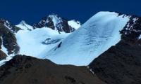
Photo travel in Almaty.
"Cirque-hanging glaciers are situated on mountain slopes. They have carved out a depression - a nival niche - that does not yet exhibit the reverse-slope bed profile characteristic of cirques. In their accumulation zone, such glaciers have a concave profile, and their termini are outlined by moraine ridges. The glacier body lies entirely within its basin, without protruding beyond the slopes."
"Glacial Structures of Northern Tien-Shan – Zailiysky Alatau"
https://elib.rgo.ru
Trip in mountains Zailiskiy Alatau.
Gorodetsky Glacier is situated at elevations ranging from 3,583 to 4,339 m. a. s. l. It lies on the northern slope of the Zailiysky Alatau Range, in the headwaters of the Ozernaya River, within the Ile-Alatau Nature Park in the Bostandyk District of Almaty.
Gorodetsky Glacier consists of two branches: the Western and the Eastern. The glacier has a perimeter of 9,596 meters and an area of 4.19 sq. km. Currently, the glacier is retreating. Between 1938 and 1961, the terminus of the left branch retreated by 320 meters, while the right branch retreated by 173 meters between 1923 and 1960.
Moraine deposits from the glacier fill the valley floor for a distance of over 5 kilometers. The total length of the left branch is 5.5 kilometers. The firn line lies at an elevation of 3,770 m. a. s. l. The western branch of the glacier originates on the steep slopes of the axial ridge, where peaks rise to heights of 4,000 meters.
The ice volume of this branch is 0.14 cubic kilometers. The firn line of this branch lies at an altitude of 3,770 m. The branch is 5.5 km long and covers an area of 3.8 sq. km. This glacier branch has been retreating since 1982. Between 1938 and 1961, the terminus of the left branch retreated by 320 m, while the right branch retreated by 173 m between 1923 and 1960.
The eastern branch is oriented westward. It originates at the ridge of a lateral spur separating the Big Almaty River basin from the Talgar River basin. The branch terminates at an altitude of 3,650 m. The ice volume of the right branch is 0.10 km. kub.
The firn line is situated at an altitude of 3,830 m.
History of study of Gorodetsky Glacier in Big Almaty Gorge.
Gorodetsky Glacier, located in the Big Almaty Gorge (in the upper reaches of the Ozyornaya River), was previously known as the Main Big Almaty Glacier (until the early 1960s). It received its current name in 1936 in honor of the researcher, dendrologist, and archaeologist Vladimir Dmitrievich Gorodetsky, who first visited and described it in 1916.
The official renaming and formal assignment of the name to the glacier took place twenty years after his initial expedition. The glacier was first visited in 1916 by Vladimir Dmitrievich Gorodetsky (1878-1957), a dendrologist and archaeologist born in Verny.
An educator by profession and a local historian passionate about the nature and history of Semirechye, he had been conducting glaciological studies of the Zailiysky Alatau glaciers since 1915. Twenty years later, the glacier was named after him.
Gorodetsky was the first to describe the glaciers at the headwaters of the Big Almaty River. On November 1, 1920, he was appointed head of the regional museum. During this period, he also served as deputy chairman of the Semirechye branch of the Russian Geographical Society; starting in the autumn of 1921, he chaired the Society for the Study of Zhetysu - an organization he founded with his associates - which operated under the auspices of the regional museum.
During the Soviet era, prominent glaciologists conducted research on the glacier, including Academician Nikolai Nikitich Palgov (1889-1970) of the Academy of Sciences of the Kazakh SSR.
Geographic coordinates of Gorodetsky glacier: N42°59'02 E77°03'48

Authority:
Alexander Petrov.
Brief Encyclopedia of the Kazakh SSR, volume 2, Nature, Alma-Ata, 1990.
Photos by:
Sergei Mikhalkov and Roman Stesenko, Almaty city.