Вы здесь
Djuku Pass.


Guide to mountains of Kyrgyzstan.
“The Zaukinskoe Gorge is formed by the flow of the Zauka River; the rivers Zaukaukuchak, Kashkasu, and Dungurama, which flow into it, also form passages with their flow. We followed the flow of the main Zauka River. The Zauka River rises gradually to the confluence of the Dungurama River, and is only blocked by transverse capes in three places. In these places, the river flows along a wide and flat valley, the slopes of the mountains are covered with dense fir forest, and the banks of the river are covered with various shrubs: barberry, honeysuckle, and rose hips. Above the confluence of the Dungurama, the passage becomes steeper and narrower and forms terraces with two alpine lakes”.
Chokan Valikhanov. "Description of route to Kashgar and back to Alatau district." 1858 - 1859.
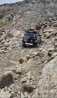
"The path leads without a noticeable rise to a cut in the Terektey-tau ridge and along it past the lakes the descent towards Juuku already begins; thus, from the side of the Arabel River there is no pass. Along the corridor among steep slopes along the sedge syrt, the path approaches the descent into the upper valley of the Juuku River. The descent is very steep, and the path runs along a scattering of large stones, often forming high steps."
V.V. Sapozhnikov. "Explorations in Naryn River Valley." 1913.
Best photos of mountains of Kyrgyzstan.
Djuku Pass (Kyrgyz: narrow gorge, gorge) is 3633.3 meters above sea level, is located in main ridge of Terskey Ala-Too Range, connects southern coast of Lake Issyk-Kul through gorge of same name with Arabel-Su River valley and plateau of same name, is located in Jetyoguz district of Issyk-Kul region.
From the northern side of the pass flows the Djuku River, 64 kilometers long, from the southern side flows the Djuku Southern River, 12 kilometers long, which is a right tributary of the Arabel-Su River. Djuku is an important natural corridor connecting low-mountain and high-mountain landscapes.
Its surroundings are distinguished by a wide variety of natural zones: from alpine meadows and coniferous forests in the gorge to the cold windy spaces of the Arabel Plateau. Here are formed the sources of mountain rivers, feeding Issyk-Kul and the upper reaches of Naryn.
Above the confluence of the Kashkasu River along the Dzhuku gorge there is a marshy plain with hummocky soil, the river flows level with the low banks. At 3.5 - 4 kilometers above the mouth of the Kashkasu, the Ittysh River flows into the Dzhuku from the right, at the right source of which, behind a chain of three lakes at an altitude of 3820 meters above sea level, there is a pass through Terskey-Alatau.
At 5.5 - 6 kilometers from Kashkasu, in the clearing of the right gorge, the snowy peak of Ittysh, 4808 meters above sea level, is visible in the south. Even further, near the confluence of the right tributary of the Dyungyuremyo, the path forks; to the south it goes to the Arabel syrty through the Djuka Pass, and to the west (to the right along the route) to the valley of the Barskoon River through the Dungurömö Pass.
To the Djuka Pass the trail climbs along large stone heaps and scree. In summer the pass excavation is mostly covered with snow. From here, 40 kilometers to the east, near the large 11.1-kilometer-long Petrov Glacier, there is the Tien Shan meteorological station.
The descent from the Djuka Pass to the south to the lake goes among harsh rocks, and then along a steep rocky slope and leads to a group of lakes Djalysh-Kel (Turkic: “Bright Lake”), near which the road from Barskoon to the Karasai syrty passes.
At a distance of about 23 - 24 kilometers to the west of the Djuku gorge there is a series of short (6-10 kilometers) gorges of the rivers Chichkan, Akterek, Kiche-Dzhargylchak, Sarybulak and Chon-Dzhargylchak (listed from east to west).
Legend of Djuku Pass
Since ancient times, people have said that the Djuku gorge was created not only by the forces of nature, but also by the intervention of the higher spirits of the mountains. The legend tells of a young shepherd named Djuku, who grazed herds on the slopes of Terskey Ala-Too.
His love for a girl from a neighboring clan was so strong that he decided to secretly lead her through the mountains to go together to free pastures. But the path lay through an inaccessible ridge. Seeing his determination, the mountain spirits took pity and moved the rocks apart, opening a path through the peaks.
Thus the pass appeared, which was named Juku. However, the spirits imposed a condition: one can only go through it with a pure heart. Those who climb here with envy or malice feel how the path becomes difficult, and the weather changes overnight. Travelers today still say that the pass tests a person: it opens the way for those who go with good thoughts, and delays those who doubt themselves.
Information for travelers going through Djuku Pass.
The Djuku Pass is popular among fans of active recreation and horse routes along the southern coast of Issyk-Kul. The ascent to it passes through the picturesque Djuku gorge, where dense coniferous forests, alpine meadows and mountain streams alternate.
On the slopes you can find pastures with yurts of local shepherds, and above there are panoramic views of the Terskey Ala-Too ridge and the Issyk-Kul valley. n the other side of the pass lies the high-mountain Arabelskoye plateau - a space of severe beauty with numerous lakes, rivers and endless pastures.
This route is interesting for hiking, horseback riding and jeep tours, but requires preparation: elevation changes, possible sudden weather changes and rare air at an altitude of more than 3600 meters make the journey a challenge. The best time for hiking is from late June to early September, when the pass is free of deep snow.
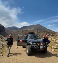
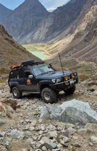
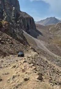
A road has been laid across the pass, which is only suitable for prepared jeeps. The upper part of the pass after the second lake, Juku Verkhnee (Dugloromo), located at an altitude of 3305 meters above sea level, is very difficult. The road is often littered with rock fragments and stones that roll down the left slope. The presence of a winch on one of the jeeps is welcome.
First researchers who passed through Juuku Pass.
June 13, 1857.
The first scientist who climbed through the Juuku Pass from Lake Issyk-Kul to the high-mountain syrts was Pyotr Petrovich Semenov-Tyan-Shansky. It was on June 13, 1857, that he overcame the "Zaukinsky Mountain Pass" (as the Dzhuuku Pass was then called).
His companion, Pavel Mikhailovich Kosharov, made the first sketch of the panorama of the Akshirak Range here, where the Sarytor peak (SNK of Kyrgyzstan) stood out clearly. In his memoirs, Semenov vividly described the difficulties of the ascent and mentioned the fields where internecine battles between the Kyrgyz had once taken place. At that time, the main threat to travelers was not the harsh passes, but possible attacks by local residents.
"Our ascent to the mountain notch leading to the top of the mountain pass lasted at least two hours, since every careless step could cost us our lives. Finally, we reached the top of the pass, which presented me with an unexpected sight; the mountain giants were no longer in front of me, and in front of me lay an undulating plain, from which snow-covered peaks rose as relatively low hills.
But the view across the lake to the south of the Zaukinsky Pass notch was even more picturesque, which was facilitated by the fact that in the lower corner of the upper lake the shale gave way to granite, which rose above its left bank as high and beautiful cliffs, and in the upper right corner of the lake mountain peaks with patches of eternal snow were visible.
Hypsometric measurement gave me 3380 meters for the absolute height of the Zaukinsky Pass."
"On June 12, the thermometer at 5 o'clock in the morning showed only 3.5 ° C. From 5 o'clock we began our ascent, but after half an hour the river divided into two branches, of which the valley of one went to the southwest, and the other - straight to the south.
The latter was indicated to us by all the Karakirghiz guides as the closest, although more difficult and less accessible for our detachment ascent to the Zaukinsky Pass. We turned along this path, but here at the last fir trees I decided to leave my entire detachment with packs and camels and only accompanied by the artist Kosharov, seven Cossacks and two Kirghiz with four pack horses and two spare horses undertook the ascent to the top of the Zaukinsky Pass.
Some of the Karakirghiz guides called the river along which we decided to climb and which, according to their stories, flowed higher through two lakes, Kashka-su, and others - Zauka. Which of the two names was more correct - remained unknown to me".
P. P. Semenov-Tyan-Shansky. "Journey to Tien-Shan". 1856 - 1857.
June 15, 1858.
The caravan of the expedition of Lieutenant Chokan Valikhanov, heading to Kashgar, passed through the Dzhuuku Pass.
1868.
The expedition of Baron Alexander Vasilyevich Kaulbars explored the area of the pass. He also studied the Akshiyrak glaciers in detail, named the moraine lake at the foot of the Petrov Glacier and the glacier itself in honor of the expedition's topographer, Fyodor Petrovich Petrov. A. Kaulbars sketched the glacier from the lake, but its outlines were conveyed schematically.
The Kolpakovsky Glacier was also mentioned for the first time, which Kaulbars called the Irtash Glacier. The book he published, "Materials on the Geography of the Tien Shan, Collected During the Journey of 1869," was primarily of an applied nature - as a guide to military and trade routes. Due to the latitude of the area covered, much of the information was given only briefly, and no additional publications on these places followed.
1886.
During a botanical expedition to the Eastern Tien-Shan, the Dzhuuku Pass was crossed by A.N. Krasnov. In his book, “Experience of the History of Flora Development in the Southern Part of the Eastern Tien Shan,” he left many descriptions of nature, and dedicated a characteristic review to the pass:
“The Zauku Pass from the south is easy to climb: the road goes along the glacier on the moraines. The descent is very unpleasant: first along the moraine, then along the ice cut by cracks, then along the giant terminal moraine among huge boulders, along slippery and narrow paths. This is the most unpleasant of all the passes I have visited.”
1903.
The Juuku Pass was overcome by the expedition of the American geologist Raphael Pumpelly. One of its participants, Ellsworth Huntington, described the geography and ethnography of the region in detail in the book The Pulse of Asia. He compared Akshiyrak and its syrts to "a huge open elevated plain surrounded by snow-capped mountains resembling a rough marble block on which the sculptor has only outlined the contours but has not yet carved the details."
1925.
An expedition of the Central Asian Meteorological Institute led by Lev Konstantinovich Davydov passed through the Dzhuuku Pass to study the upper reaches of the Naryn River. The goal was to determine the hydrological characteristics that affect the runoff. During the expedition, the Petrov Glacier was studied in detail for the first time, many photographs were taken and nearby glaciers were described. However, the areas beyond the passes from the Petrov Glacier remained unexplored.
1929.
This year, Nikolai Nikitich Palgov's expedition attempted to pass through the pass, which studied Akshiyrak from the eastern side, along the Ittish River valley. Due to heavy snow and the threat to the horses, the expedition was unable to reach Issyk-Kul via Dzhuuku and returned via the Kashkasu Pass.
At the same time, the Tien-Shan hydrometeorological station, created on the initiative of L.K. Davydov, began operating near Lake Petrov. All construction materials were delivered via the Dzhuuku Pass on horses; and today, on the southern slopes of the pass, you can find piles of bricks dropped during those shipments.
Geographical coordinates of Djuku Pass: N41°56'37 E77°50'09
Authority:
Alexander Petrov.
Freyman Sergey Igorevich.
B.I. Rukavishnikov. "Lake Issyk-Kul and Terskey Alatau Ridge." 1970.
Photos by:
Lyudmila Kempel, Almaty.
https://www.facebook.com/alexander.petrov.426340/


