


![]()
Вы здесь
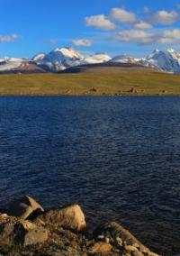
Lake Kagalyachap North.
Trip on river Kotur in Western Kokshaal-Too.
“The more you travel around your native country, the more you see, the more you are surprised by its endless diversity, expanses, inexhaustible, non-repeating beauty of nature, the more you love your Motherland. And this feeling knows no bounds.
"Years of searching in Asia.". EM. Murzaev.
Mountaineering expedition to Kyzyl-Asker massif.
The fresh, flowing lake Kagalyachap North is located at an altitude of 3758 meters above sea level, is located in the northeastern part of the Kagalachap watershed plateau, 4.2 kilometers southeast of the Kubyurgenty pass located at an altitude of 3907.2 meters above sea level, between the northern slopes of the Western Kokshaal-Too ridge and the southern slopes of the western part of the Borkoldoy ridge and the eastern part of the Naryn-Tau ridge in the Naryn region.
The lake is 315 meters long from west to east, the largest width in the central part is 232 meters from north to south, the lake area is 0.05 square kilometers, the perimeter reaches 1.06 kilometers. The lake lies 785 meters southeast of the highway between the Kendy and Karakoz border posts.
Lake Kagalyachap North is located near the so-called Aksai glaciation node, on a 129-kilometer stretch between the outbursts of the Western and Eastern Ak-Sai (Kokshaala) and Uzengegush rivers. The watershed of these rivers from the north of the Kokshaal-Too ridge is the Kagalyachap plateau, located in the southern part at an altitude of 4323.4 meters above sea level and in the northern part at an altitude of 3097.2 meters above sea level (Kubyurgenty pass), located south of the Kyzyl massif -Asker, between the northern slopes of the Western Kokshaal-Too ridge and the southern slopes of the western part of the Borkoldoy ridge and the eastern part of the Naryn-Tau ridge in the Naryn region and only a small part of the northeastern part lies in the Issyk-Kul region.
The high-mountainous Kagalyachap plateau, these are high-mountain syrts, including lowlands, the permafrost zone dominates here. Wetlands are not uncommon up to an altitude of 4000 meters above sea level.
The snow line is located at an altitude of about 4000 - 4500 meters above sea level. The river valleys have a high absolute height of about 3000 - 3500 meters above sea level. The climate on the plateau is harsh.
Average monthly temperatures in summer are about + 5 + 8 C, the weather is unstable. 11.1 kilometers southwest of the lake is the tongue of the Kotur glacier, located at an altitude of 3989 meters above sea level. 11.8 kilometers to the south is the tongue of the Kyzylunet East glacier, located at an altitude of 4043 meters above sea level.
1.1 kilometers to the northeast is Kagalyachap Lake, located at an altitude of 3789 meters above sea level. In winter, the lake freezes, and there are a lot of algae in the lake.
Geographical coordinates of Lake Kagyalachap North: N41°12'41.44" E77°24'07.07"
Authority and photos by
Alexander Petrov.