







Вы здесь
Glaciers on northern slope of Zailiysky Alatau.
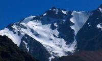
Glaciers in river valleys of Zailiysky Alatau.
“Right by the pass (leading to the Chong-Kemin River valley), deep within small cirques, lie three small glaciers - each no more than 500 meters long - oriented toward the northeast. Larger glaciers are situated on the opposite side of the valley. Two glaciers exceeding 2 kilometers in length are clearly visible.”
N. N. Palgov. *Glaciers of the Upper Kaskelen River* and *Glaciation of the Kaskelen River Valley in the Zailiysky Alatau*. 1939.
A walk through gorges of Zailiysky Alatau.
The vast majority of glaciers in Kazakhstan originate from mountain ridge crests. Based on this, one can infer that the longer and higher the upper boundary of a glacier's firn fields, the larger the glacier is likely to be. As mountain elevation increases, the glaciated area expands unevenly across specific intervals of the firn field's upper boundary: valley glaciers develop most successfully, followed - in order of increasingly unfavorable orographic conditions - by apron glaciers, then cirque and hanging glaciers; the latter are relegated to steep ridge slopes where conditions for snow accumulation are highly unfavorable.
The minimum ridge elevation required for the formation and at least sporadic existence of a glacier is found in hanging and cirque types; an increase in elevation of 100 meters allows for the emergence of apron glaciers, while valley glaciers can form at an elevation 150 meters higher still.
Depending on the aspect of the slope, both the absolute elevation at which various glacier types originate and the total glaciated area - relative to the elevation range of the upper limit of firn fields - vary. Valley and apron glaciers on the southern slope originate 100-150 m higher than those on the northern slope; apron glaciers originate 80-100 m higher, cirque glaciers 60-80 m higher, and hanging glaciers 50 m higher.
At comparable ridge elevations, the glaciated area per kilometer of ridge length is greater on northern slopes than on southern ones: by 0.23 sq. km for valley glaciers, 0.08 sq. km for apron glaciers, and 0.03 km² for cirque glaciers; for hanging glaciers, there is practically no difference, as their formation conditions are similar (Vilesov, 1973).
The basins containing the glaciers are not entirely filled by them; portions of the bed and surrounding slopes remain free of ice and snow. The sunnier the basin's aspect, the greater the extent of this ice-free area. Calculations performed by E. N. Vilesov for 210 glaciers in the range - covering a total area of 253 sq. km - demonstrated that the degree to which glaciers fill their basins and their "viability" depend on mountain elevation: the higher the mountains, the more fully the glaciers occupy their basins and the greater the ratio of accumulation and ablation areas to the total basin area.
Valley and piedmont glaciers fill their basins more completely than cirque or hanging glaciers. The existence of modern glaciation - both overall and for specific glacier types - at a given elevation in the Zailiysky Alatau depends more on the depth of mountain dissection (which determines the glacier's morphological type) than on climatic conditions.
Glaciers cover an area of 297 sq. km on the northern slope of the Zailiysky Alatau. This glaciated area accounts for approximately 11% of the total mountainous territory within the river basins of this slope. Glaciation is most extensive in the highest part of the range, dominated by the Talgar-type massif; it gradually diminishes to the west and east of this area.
Glaciers in Uzunkargaly River basin.
The headwaters of this basin are highly branched. The river is formed by numerous tributaries originating in snowfields and glaciers. The mountain ridge enclosing the river basin is covered with perennial snow along almost its entire length. The lower snow line descends an average of 100-150 meters vertically from the ridge.
The highest peak reaches 4,232 meters. There are up to nine glaciers in total, mostly of the cirque and hanging types; the largest do not exceed 2 km in length. Some of these glaciers were observed from a distance in August 1933 by the geologist S. I. Letnikov.
Glaciers in Chemolgan River basin.
The morphological conditions for glaciation here are similar to those in the Uzunkargaly River basin. The main peak reaches an elevation of 4,094 m, and the snow zone extends vertically no more than 150 m. Four glaciers lie at the headwaters of the river's four tributaries; they were first recorded in September 1933 by V. G. Gorbunov.
Three of the glaciers are cirque glaciers, and one is a hanging glacier. Their termini all face north toward a broad basin that bears traces of ancient glaciation. The largest glacier - the westernmost one—is approximately 1.5 km long. It terminates beneath a long frontal moraine and gives rise to the main source of the Chemolgan River.
The other two cirque glaciers are located further east, separated from the western glacier and from each other by short rocky spurs. The fourth glacier is essentially a permanent snow patch occupying the upper part of a cirque's headwall; a small lake lies at the bottom of the cirque.
Ridges of moraine, deposited during the glacier's retreat, extend in front of its terminus.
Glaciers in Kaskelen River basin.
The upper part of the Kaskelen River basin is notably wide, reaching up to 19 km. The highest points of the ridge reach 4 km or slightly more. One peak, situated on the border with the Aksay River basin, has an elevation of 4,206 m. However, the average elevation of the ridge's axial section does not exceed 3,900 m.
Consequently, the vertical extent of the glaciation zone averages no more than 150 m. At least ten glaciers are situated along the 19-kilometer stretch of the main ridge's slope.
V. G. Gorbunov, who visited the headwaters of the Kaskelen River in 1930 and 1933, wrote the following about them:
“Right by the pass (leading to the Chong-Kemin River valley), three small glaciers - each no more than 500 meters long and facing northeast - lie within small cirques. Larger glaciers are located on the opposite side of the valley. Two glaciers exceeding 2 kilometers in length are clearly visible” (N. N. Palgov, 1939).
The two glaciers mentioned by V. G. Gorbunov are the easternmost ones in the basin. One of them was observed in 1949 by the geologist D. N. Kazali, who classified it as a short valley glacier.
Glaciers in Aksay River basin.
The headwall of the basin - which rises to a maximum elevation of 4,500-4,600 meters above sea level according to some sources, and only 4,100-4,200 meters according to others - extends for 10 kilometers along the ridge crest. According to observations by V. G. Gorbunov, who visited the headwaters of the Aksay River in 1936, more than 15 glaciers are situated in the gorges and cirques of this wall.
At the headwaters of the Left Aksay, above two small tarns and on the slope of a 4,206-meter peak, lies a northwest-facing cirque glacier up to 2 kilometers in length. Gorbunov named it the Kraevedov Glacier. Four glaciers were discovered at the headwaters of the Sredniy Aksay.
The largest was named after the renowned Kazakhstani zoologist V.N. Shnitnikov. Situated in the highest parts of the basin with a northern aspect, this glacier descends further into the valley than any of the others. It is classified as a cirque glacier. It measures approximately 4 km in length; its width is about 3 km in the upper section and 300-400 m at the terminus.
The glacier's tongue is short and extends beneath moraine deposits; the terminus features numerous meltwater channels and ice caves. Nine glaciers were recorded at the headwaters of the Pravyy Aksay. The largest, including its firn fields, is no more than 2 km long.
Its tongue descends at an angle of 5-8° and stops 10-15 m short of the frontal moraine, which rises as a small ridge in front of it. The remaining glaciers are smaller. They are located either in narrow cirques - occupying only a portion of the floor - or are suspended on mountain slopes, abutting small crescent-shaped moraines up to 50 m high.
Two of these hanging glaciers are approximately 1.5 km long each.
Authority:
"Glacial Structures of the Northern Tien Shan – Zailiyskiy Alatau"
https://elib.rgo.ru
Photos by:
Alexander Petrov.