







You are here
Lyubovinskaya (Kaskelen) Cossack Settlement.
Cossack settlements in Semirechye Region.
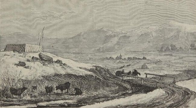
"The road between Pishpek and Verny is largely mountainous; one often has to cross mountain passes, and the ascents and descents are quite steep. Beyond Verny, along the route, lie two satellite settlements; the first of these (Lyubovny) is quite substantial, comprising over 200 households. In addition to farming, the residents cultivate fruit trees - such as apricots, seedless grapes (kishmish), pistachios, walnuts, apples, and table grapes - not to mention melon patches. Horticulture is a significant source of income here."
G. N. Potanin. "Siberia newspaper". 1879, No. 10 (March 11).
"The Lyubovny (Kaskelen) settlement is the last stop before Verny. This settlement is populated by Cossacks transferred from Siberia who became part of the Semirechye Cossack Host. The village makes an extraordinarily pleasant impression. A quintessentially Russian village suddenly appears before one's eyes, with a charming church in the center. The wooden houses - neat, tidy, and toy-like - look out cheerfully through large windows, while their plank roofs glisten in the bright sunlight. The streets are wide and straight, lined with young trees. Small gardens are frequently found beside the houses."
Major General of the General Staff L. F. Kostenko. "Essays on the Semirechye Region". 1872
Stanitsa (Cossack settlement) of Lyubovinskaya (Kaskelenskaya) was established in 1860 on the Kaskelen River - in the northern foothills of the Zailiskiy Alatau - as the Cossack outpost of Lyubovny. It was founded by Siberian Cossacks from the 6th sotnia (company) of the 9th Siberian Regiment, led by sotnik (captain) Kruglykhin, and comprised 143 Cossack families.
In 1861, 10-12 peasant families from the Tobolsk and Tomsk provinces were settled there and enrolled in the Cossack estate. In 1902, the outpost was renamed the stanitsa of Kaskelenskaya; in 1918, it became the village of Trotskoye (Troitskoye); and in 1929, it was renamed the village of Kaskelen.
It is currently the city of Kaskelen in the Almaty Region (Republic of Kazakhstan).
Origin of word Kaskelen.
Kaskelen is the name of a river - from which the city takes its name - and is explained as meaning "bald" (kaska) or "agile" (elen) (Koichubaev, 130). We, however, link the toponym to the Proto-Iranian kah, kas - meaning "to open up, to gape; to split, to cleave, to crack" (ESIYa, 4, 169) - implying a gorge formed by the splitting and cleaving of mountains.
A connection to the Turkic kasyk - referring to "any part of the body with folds, the lower abdomen, or the groin" - or to kys (meaning "narrow," "to crowd," or "to squeeze") is less likely (ESTYa, K, Vol. 1, 329, 331–332; Vol. 2, 247).
A similar word is found in Old Iranian (kas), Persian (kos), and Tajik. kus "vulva" (ESIYa, Vol. 4, 411-412; ESVYa, 222).
The formant kas - appears in river names (e.g., the Kaskasu River in the Chilik River basin in the Kungei-Alatau) and, much less frequently, in village names (resulting from the transfer of hydronyms). A connection is possible with the Indo-Aryan kas - meaning "to go, move" or "to sparkle, shine" (Kochergina, 156) - referring to flowing water in the context of the hydronym.
We identify the second element, Kelen, with the Sanskrit “kulya” ("canal, stream") and *kulini* ("river, torrent") (Kochergina, 168, 170), as well as the Digor “kaelun” ("to pour, flow, spill") (DRS, 317; ESOYa, 1, 578). According to Illich-Svitych (No. 177), the Nostratic root (Hamito-Semitic, Uralic, Dravidian, Altaic, Indo-European) is “kula”, meaning "lake, pond, body of water, bay, river."
The probable meaning of the Kaskelen River is "a river flowing through a mountain cleft/gorge" or "a moving, flowing (stream) washing against (slopes and banks)."
Formation of the Lyubavinskaya stanitsa.
By the end of April 1860, the “sotnia” (cavalry company) had gathered at its assembly point - the stanitsa of Antonievskaya - and set out on April 29 as a single contingent, aiming to reach the fortification of Vernoye by June 30. The company comprised 143 families - 29 having volunteered, 86 selected by lot, and 28 assigned - and included 147 active-duty Cossacks, 7 retired Cossacks, 65 youths, 131 Cossack wives, 5 widows, and 88 unmarried women, making a total of 443 souls.
The Cossacks transported nearly all their farming implements and household belongings, traveling in 325 wagons drawn by 582 horses and driving 268 head of cattle. Despite the party's cumbersome composition, it was assigned an itinerary typical of a standard mounted military unit - one unencumbered by families or livestock and heavy equipment.
The company was required to cover 1,387 versts in 63 days; of the scheduled stages, only 22 were 25 versts or less, while 22 ranged from 25 to 30 versts, and 10 exceeded 30 versts. Out of the 63 days of the march, only 9 rest days were allotted, including the time required to cross the Irtysh River.
Naturally, under such conditions - and especially in the spring mud - the migrating company could not even come close to adhering to the schedule. As early as May 18 - that is, after 20 days of marching... Sotnik Kruglykhin, the commander of the detachment, reported to the Military Governor of the Semipalatinsk Region that the scheduled daily marches were too long; due to overloaded wagons and a shortage of fodder, the sotnia (cossack company) could cover no more than 12-15 versts a day.
He stated that, despite his best efforts, he would likely not reach the Irtysh River crossing near the Shulbinsky settlement before May 25, whereas the itinerary required him to be there by the 12th. Apparently fearing the consequences of a delay, Kruglykhin pushed his detachment hard; instead of the anticipated May 25, he reached the Irtysh on the 23rd.
However, a new, unforeseen obstacle awaited him there: the Shulbinsky settlement had only one ferry, and transporting the detachment across the Irtysh took nine days. The crossing was completed only on June 1, and the sotnia moved on, heading via Ayaguz and Kapal toward Verny; they arrived at their designated settlement site on July 25.
Gasfordt had designated the Kaskelen River valley - near the point where the river emerges from the Zailiysky Alatau range, in the northern foothills - as the site for the settlement. Upon settling there, the 6th sotnia established the Lyubovny settlement, which was later renamed the Kaskelen stanitsa (Cossack village).
This marked the last major Russian migration to the Semirechye region, not only for the period under review but for the entire second half of the XIXth century. In that same year, 1861, ten or twelve peasant families settled here. By 1901, the population of the Lyubovny settlement had reached 1,518 souls of both sexes; consequently, in 1901, the settlement was designated a stanitsa and named Kaskelenskaya, after the mountain river on which it is situated.
"The stanitsa administration of the new *stanitsa* did not commence operations until January 1, 1902."
Cossack historian N.V. Ledenyov. “History of the Semirechye Cossack Host”. 1909.
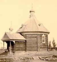
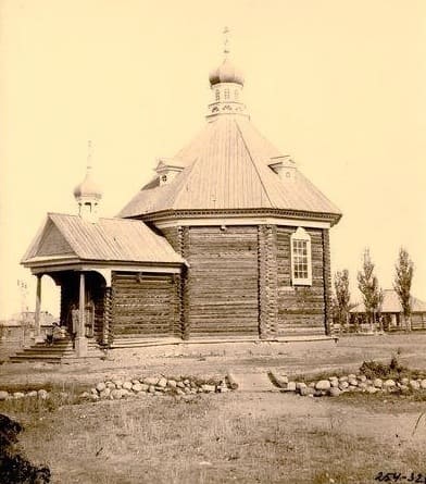
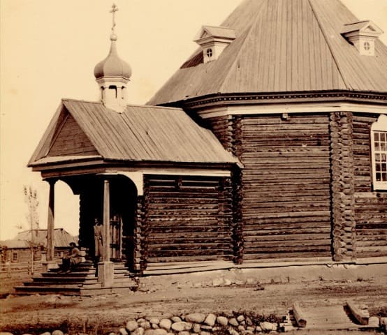
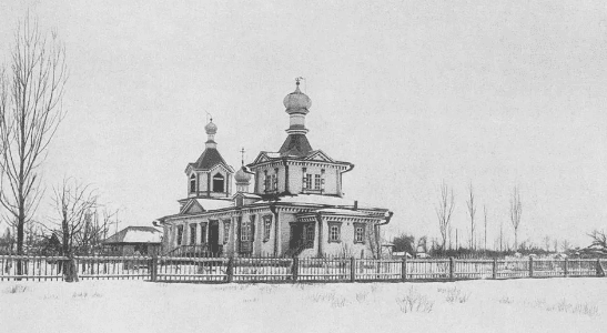
Lyubavin Church of St. Michael the Archangel.
The first wooden Church of St. Michael the Archangel in Lyubavinskaya was built in 1866-1867 in the traditional "Siberian style" using local Tian Shan spruce and set upon a stone foundation. The first parish in the Cossack settlement of Lyubovny was established in 1865.
Records indicate the first church was constructed between 1866 and 1867; it was a small, tent-roofed structure clad in hewn planks. From 1868 onwards, the Lyubavin church carefully maintained and regularly updated its income and expenditure ledgers, parish registers (covering 1867-1873), and confession records (dating from 1868), which listed the names of all parishioners - both those who had attended confession and those who had not.
By the time of the 1898 census, the population of Lyubavinskaya stanitsa (Kaskelen) had reached 2,800, and the original church had become too small. Furthermore, as the structure had sustained significant damage during the 1887 earthquake, the decision was made to build a new, larger church on the same site.
Construction was funded partly by church resources and partly through donations from parishioners. The new Church of St. Michael the Archangel was completed in 1900 under the supervision of construction engineer Yakov Poroshin. On June 4, 1900, the church was consecrated by Archpriest Alexander Novikov, the district dean.
Archive of Alexander Yuryevich Ushakov.
“In 1860, G.Kh. Gasfordt, the Governor-General of Western Siberia and the Separate Siberian Corps, relocated the 6th sotnia (company) of the 9th Siberian Regiment - in its entirety, including their families - to the vicinity of Verny. Initially, the Governor-General planned to settle them along the Kastek River.
However, under pressure from Gerasim Kolpakovsky, the head of the Alatau District, he changed his decision and ordered the settlement to be established in the Kaskelen River valley. On April 29, 1860, 143 families under the command of Sotnik (Captain) Kruglykhin set out toward Semipalatinsk, with a planned arrival in Verny on June 30.
Of the 143 families, only 29 were relocating voluntarily; another 86 families were selected by lot, and 28 by order. The convoy consisted of 443 people, 286 head of cattle, 582 horses, and other property. The journey to Semirechye was prolonged, taking more than 90 days.
The settlers did not arrive in Verny until July 29. The settlement on the Kaskelen River was named Lyubovinsky - after Lyubov (Love), the third of the Holy Trinity. Later in 1860, another 12 families moved to Lyubovinsky, followed by 18 more peasant families.
A year later, the settlement was home to about 700 people across 156 households. The residents primarily engaged in grain farming and cattle raising, activities facilitated by the fertile land and pastures. The region's widespread development and proximity to Verny led to the settlement's growth: by 1901, the population had reached 1,518, and the settlement was renamed stanitsa Kaskelenskaya after the river flowing through it.
As of January 1, 1913, the stanitsa comprised 411 households and 3,589 residents. It also featured a large church - St. Michael’s - capable of accommodating up to 300 parishioners, as well as two parish schools and a church school for girls.
11 mills and an oil-pressing plant. In 1918, the stanitsa was renamed the town of Trotsky. The settlement bore the name of the disgraced revolutionary until 1929.”
Writer A. Lukhtanov.
G. N. Potanin on Lyubavinsky vyselok (satellite settlement).
"The road between Pishpek and Verny is mountainous for the most part; one often has to cross mountain passes, and the ascents and descents are quite steep. Beyond Verny, along the route, lie two satellite settlements; the first of these (Lyubovny) is very substantial, comprising over 200 households.
In addition to farming, its residents cultivate fruit trees - such as apricot, seedless grape, pistachio, walnut, apple, and grape varieties - not to mention melon fields. Horticulture is a major source of income here."
G. N. Potanin. "Sibir" newspaper. 1879. No. 10 (March 11).
Authority:
Archive of the Kazakhstani linguist and historian Alexander Yuryevich Ushakov. 2024.
https://russiainphoto.ru/search/photo/?index=8&author_ids=4812&paginate_page=1&page=1