


![]()
Вы здесь
Tour of Kazakhstan.


Tours Astana Kazakhstan.
“Not all those who wander are lost”
J.R.R. Tolkien.
Short description of route of tour on Central, Western and Southern Kazakhstan:
Astana - settlement Akmol - museum "ALZHIR" - Kashkar-ata necropolis - Blue bay - canyon Kapamsay - underground mosque Shakpak-ata - mount Akmaya - valley Torysh - mount Sherkala - yurts camp "Ethnography Aul" - settlement Shetpe – saline land Tuzbair - mausoleum Kostam - Shopan-ata mosque anf necropolis - mount Bokty – Baysary valley – Boszhira valley - Ustyurt reserve - hollow Karynzharyk - town Zhanaozen - Karagie hollow - town Aktau - Almaty - Issyk burial mound - lake Issyk – valley-canyon Aktogay - lake Kaindy - lake Kolsay I - Charyn canyon - Altyn-Emel national park - valley Tamgaly-tas - Big Almaty lake - show with birds of prey.
Distance route: 2210 km.
Season: April - September.
Best time for an tour: April, May, September
Duration: 12 days, 11 nights.
Detailed program of tour day by day on Astana, natural and historical sights of Mangyshlak and to national parks of Southern Kazakhstan:
Kazakhstan Trips and Tours.
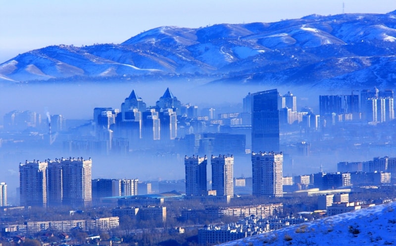
Day 1. Astana.
Arrival in Astana. A meeting at the airport, transfer to hotel, accommodation. Rest. Lunch. After lunch an excursion in Astana. Visit of the mosque of Khazrat Sultan. The mosque is located on the right river bank Ishim, near the American Embassy, near a monument the Kazakh Eli also with the Palace of Peace and Reconciliation. The main mosque of Astana is built of white marble.
The second-large mosque in Central Asia after the mosque in Turkmenistan "Spirituality of the Turkmenbashi Construction of the cathedral mosque "Khazrat Sultan" began in Astana The building is built in classical Islamic style with application of traditional Kazakh ornaments. To Khazret Sultan mosque can be located 5000 praying, in holidays - to 10 000 people. The mosque "Khazrat Sultan" has the biggest dome in Kazakhstan 51 meter high and diameter in the basis of a dome of 28,1 meters. In the mosque there are also eight small domes diameters - 10,45 both 7,6 meters, and tops - 33,46 and 25, 25 meters. In corners of the mosque 4 minarets 77 meters high are placed.
After visit of the mosque of Khazrat Sultan, transfer to Nur Astana mosque. Visit of the mosque. At the mosque four minarets 62 meters high everyone. Domes are covered with gilding. The mosque is built on the project of the Lebanese architect Charles Hazif. Height of the main dome of the mosque 43 meters.
After excursion to mosque, transfer to shopping mall - "Khan Shatyr". From here our excursion on Nurly Zhol avenue will begin. So behind the back of us the “Khan-Shatyr” complex created on the project of the English architect Norman Foster. Visit of a trade entertainment complex of Khan Shatyr, aquarium.
We go further, through the Gashyktar park, through an arch of the popular office building with gilded glasses to Nurly Zhol avenue, a housing estate "Vodno-zelyony Avenue", buildings of the company OA "Kazakhstan Temir Zholy" (nickname "Lighter"), business center "Emerald Quarter", a housing estate "Polar lights", a monument Astana-Bayterek. Height Astana-Bayterek of 105 meters, diameter of a sphere is 22 meters. In a sphere the bar and the panoramic hall are located.
The House of the ministries, the building of the Government of Kazakhstan, the Supreme Court of the Republic of Kazakhstan is far. The zvenue comes to an end with the residence of the president of “Ak Orda”. End excursion. Transfer to restaurant, dinner. Transfer to hotel, overnight.
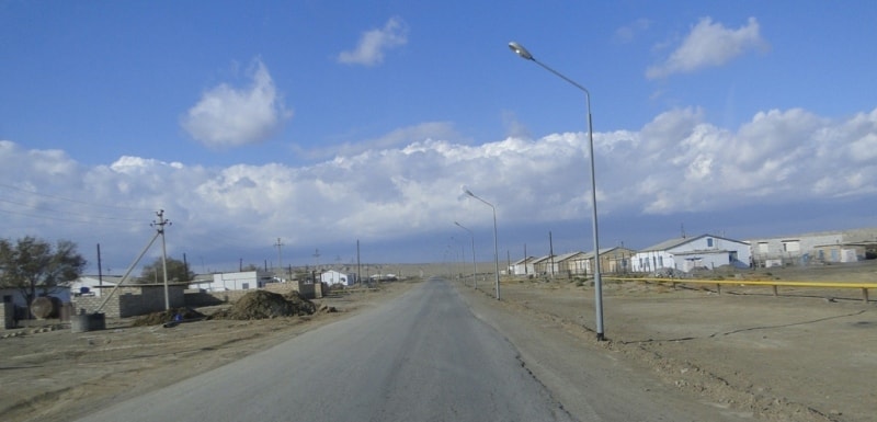
Day 2. Astana - settlement of Akmol (36 km).
Breakfast. Transfer: Astana - settlement of Akmol (36 km). Our way from Astana goes on Korgaldzhin Highway to the settlement of Korgaldzhino which is the administrative center of Korgaldzhin district. Further the road conducts to the Korgaldzhino reserve. We pass city housing estates, the lake Taldykol and the road conducts us on the southwest. On the right housing estate Urker and cottage town of families of officers of army of Kazakhstan, settlement of Karaotkel.
Soon we in the settlement of Akmol, called the settlement earlier - the Robin. The settlement of Akmol is located in the Tselinograd district of the Akmola region on the bank of the lake Zhalanash, which belongs to Tengiz to system of lakes. In a northern part of the settlement there is a museum ALZHIR (Akmola camp of wives of traitors of the Homeland). The Akmola camp was the largest concentration camp in the USSR for wives of traitors of the Homeland and their children.
The museum and memorial complex opens a monument "A grief arch", two compositions "Despair and powerlessness", "Fight and hope" follow further. The complex also includes: the museum building, "The Stalin carriage", the Wall of memory and memorable plates established by the embassies accredited in the Republic of Kazakhstan. An excursion in the museum, visit of a museum exposition.
Visit of Russian Orthodox Church and the central square in the settlement of Akmol. End of an excursion, return to Astana. Arrival in Astana. Lunch in restaurant. After a lunch visit of the national museum of Kazakhstan. The National Museum of Kazakhstan is composed of the following halls: Hall of Astana, Hall of Independent Kazakhstan, Hall of Gold, Hall of Ancient and Medieval History, the Hall of History, Ethnography Hall, Halls of Modern Art.
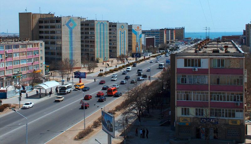
The largest unique museum complex has an area of 74,000 sq.m. and consists of seven blocks with a variable number of storeys to the ninth floor. Exhibit space occupies 14 rooms with a total area of over 14,000 sq.m. After the excursion in the national museum, transfer to the airport. Departure to Aktau. Arrival in Aktau, meeting at the airport, transfer to hotel, accommodation. Dinner and overnight.
Day 3. Aktau - yurts camp “Ethnographic aul” (225 km).
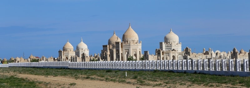
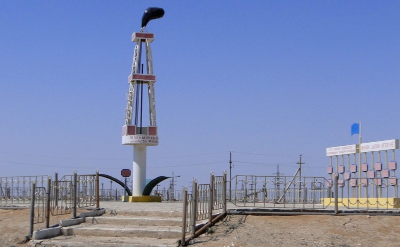
Breakfast. After breakfast we leave the city in the direction of the Aktau airport, we pass the village of Akshukur, opposite to the village there is Kashkar-ata necropolis (20 km) on the right. Visit of a necropolis of Kashkar-ata.
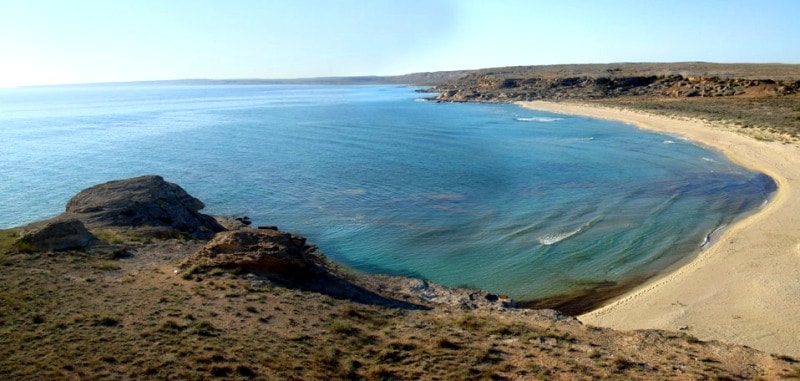
Further transfer: Kashkar-ata necropolis - the Blue bay on the Caspian Sea (59 km). From the western break at the Caspian Sea, the boundless blue smooth surface of the sea is well looked through. Visit of the Blue bay, walk in vicinities.
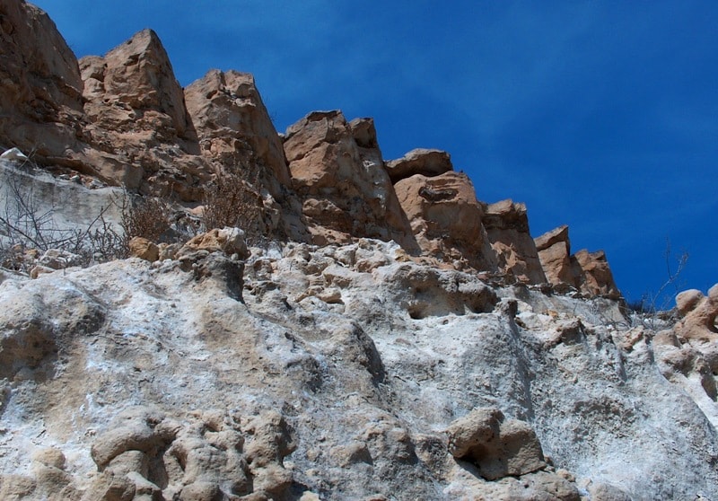
Transfer: Blue bay - a canyon of Kapamsay (38 km). Arrival in a canyon of Kapamsay, walk in vicinities, photography of aeolian aerations which are similar to bee honeycombs.
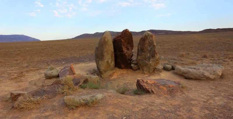
Transfer: canyon of Kapamsay - the underground mosque of Shakpak-ata (8 km). Arrival to Shakpak-ata mosque. Walk to the underground mosque which is built on the edge of a rocky ledge. Visit of the mosque, walk on edge of rocky break, walk in vicinities. Descent from break, visit of an ancient necropolis of Shakpak-ata.
Transfer: Shakpak-ata mosque - mount Akmaya (44 km). Walk in the neighborhood of the mount Akmaya, photography of the well-known opening in the rock.
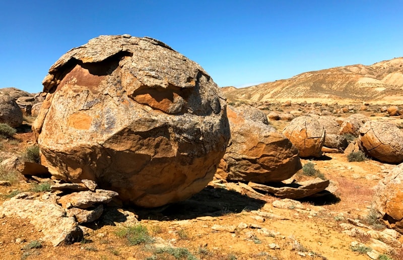
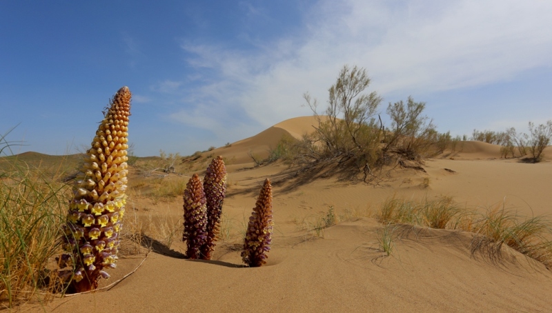
Further transfer: mount Akmaya - valley Torysh (10 km). We cross Tauchik Highway - Zhyngyldy and we go to the southeast by the beginning of stone spherical concretions of the valley Torysh. Geological walks on the way to the valley. Arrival in the valley Torysh. Lunch in way.
Transfer: valley Torysh - mount Sherkala (38 km). On the way visit the valley Akmysh, here among high trees proceeds a stream, there is the Kazakh girl's sculpture. Short walk in the neighborhood of the valley Akmysh, visit of excavation of the ancient settlement Kyzyl-kala.
Transfer to Sherkala mount. On the way visit of spherical stone concretions of the bizzare shapes, visit of an ancient mazar and necropolis located from West side of the mount Sherkala. Photography of vicinities, paleontologic finds of sinks of ammonite. End of walk.
Transfer: mount Sherkala - yurt camp “Ethnographic Aul" (8 km). Arrival in the yurt camp, accommodation, dinner and overnight.
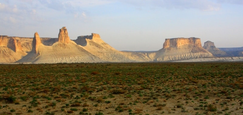
Day 4. Yurts camp “Ethnographic Aul" – Boszhira valley (280 km).
Breakfast. Early morning transfer: Yurts camp - settlement of Shetpe (21 km). On the way a stop in the settlement of Shetpe, here we will fill up reserves of drinking water and we will make necessary purchases in shop.
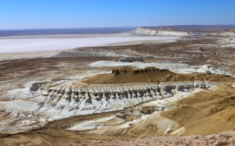
Further transfer: Shetpe - saline land Tuzbair (96 km). Arrival on saline land Tuzbair. Walks in the neighborhood of the well-known arch of Tuzbair, the mount Tuzbair 272 meters above sea level on the Ustyrt palteu.
Further transfer: saline land Tuzbair - tomb of the saint Manata-ata - pass of Manata (12 km). A stop at a tomb of the saint of Manata-ata, photography of the most beautiful, multi-colored mountain to the left of the road. Rise on cliff Ustyurt, a stop on the brink of cliff, photography of a panorama of saline land Tuzbair from cliff height.
Transfer along the Western chink of Ustyurt (29 km). From cliff height we observe saline land Tuzbair - the mount Tortkol of 285 meters above sea level, the mount Tuzbair of 272 meters above sea level. A lunch in way. A stop on the brink of cliff of walk in the neighborhood of saline land Tuzbair.
Transfer: saline land Tuzbair - descent from the Western break of Ustyurt - the mausoleum to Kuy-Tam (XIIIth century) (68 km). Our way lies on the southeast to the place from where Mangyshlak Muslim shrines - mausoleum to Kuy-Tam who opens a way for pilgrims to the most significant mosques of Mangyshlak begin. Visit of the mausoleum, photography.
Transfer: the mausoleum to Kuy-Tam - Shopan-ata necropolis in Kyzylsu valley (2 km). Arrival on Shopan-ata necropolis. Walk to the underground mosque and Shopan-ata necropolis. Walk and photography, ritual walk by the top part of the underground mosque.
Transfer: Shopan-ata - mount Bokty (46 km). Arrival to Bokty mount. Walk in vicinities.
Further transfer: Bokty - Baysary valley (13 km). Walk in the neighborhood of Baysary valley.
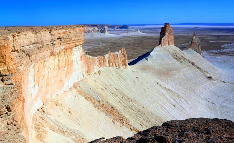
Transfer: Baysary valley – Boszhira valley (37 km). Our way to Boszhira valley lies on edge of a picturesque cretaceous hollow which is to the right of us, walk on a hollow, photography of vicinities. Arrival in Boszhira valley. Walk in vicinities, photography of Azu tistery of Boszhira and other sights of the valley. Transfer to the cretaceous foot of the mountain Ulken keme Boszhira. Dinner and overnight in tents
Day 5. Valley Boszhira - hollow Karynzharyk (130 km).
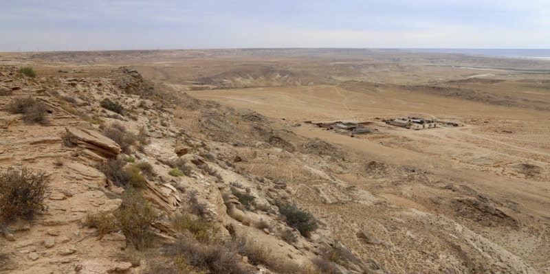
Breakfast. Transfer: valley Boszhira - settlement Ak-Kuduk - plateau Ak-Kuduk - sand Karynzharyk - reserve Ustjurtsky - hollow Karynzharyk (130 km). We leave one of the most beautiful places of Mangyshlak and road conducts us on the south to new and novel beauty Mangyshlak. On a way the small settlement Ak-Kuduk which has got lost in sand of Mangyshlak is passed, here it is possible to fill up stocks of water.
On a way visiting of small plateau Ak-Kuduk with which wonderful and unforgettable kinds on surrounding steppes open. Further we cross sand Karynzharyk with beautiful panoramas of cretaceous adjournment in the western part of sand. We pass sand and our way proceeds on an equal surface of plain which borders on hollow Karynzharyk which is on 75 meters below a sea level. Lunch in a way.
Visiting of a cordon of reserve Ustyrt, transfer to a southeast extremity of a hollow. Placing of camp on the western slope of a hollow. Directly before us kinds on unique islands Three Brothers in saline land, located in a southern part saline land. Dinner and overnight in the tents.
Day 6. Depression Karynzharyk (Elchibek) - town Aktau (260 km).
Breakfast. Walk in vicinities of depression Karynzharyk, descent to bottom of depression, walk on shor Karynzharyk. Photographing. Returning in camp. Lunch. After lunch transfer to Aktau. On the way before 30 km from city the asphalt road crosses one of deep depression of Kazakhstan - Karagie (-132 meters below level of Baltic sea). The deepest place where there passes motorway - 119 meters below sea level.
Through 50 km we turn from asphalt and we pass 13 km on steppe roads to panorama on depression Karagie in district Sautty. A stop for photographing. Here rocky breakage has radonic thermal chink. Descent on mountain track, borrows 10 - 15 minutes. Here it is possible to be expiated. After visit to Karagie depression transfer to Aktau. Arrival in Aktau, transfer to hotel, accommodation, dinner and overnight.
Day 7. Aktau - Almaty.
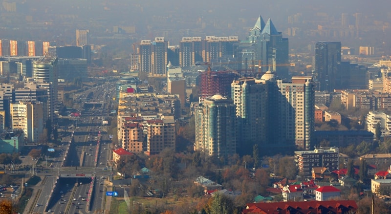
Breakfast. Transfer to the airport, accompanying service at departure to airport on morning flight to Almaty. Arrival in Almaty, a meeting at the airport, transfer to hotel, accommodation. Beginning of an excursion across Almaty. Visit of the main market of the city "Green market" (1875), here it is possible to feel exotic of east market. After walk on a market visit of company shop of Rakhat confectionery (1942), in shop you will feel a kingdom of chocolate and candies.
Walking to the park of 28 guardsmen Panfilov men (1868), visit of Ascension Cathedral of the architect Andrey Zenkov (1904), visit of a memorial of Glory and an eternal flame (1975), visit of the museum of musical instruments (1980). Transfer to the national historical museum (1985), visit of galleries and showrooms, the "gold" room of juice. In this museum there is gold of juice which was found at excavation of burial of the Gold person on Issyk burial mounds in the neighborhood of the settlement of Issyk.
Lunch at national restaurant. After a lunch walk on the mount Kok-Tobe. Transfer to the cable way station "Kok-Tobe" at the palace of the Republic. Rise on the cable way on the mount Kok-Tobe (1070 meters above sea level 1,7 km, 5 minutes). Walk in the neighborhood of the mount Kok-Tobe. From the observation deck, the view of the city and mountains of Zailiyskiy Ala-Tau opens. Visit of a zoo, monument to the Beatles group, shop of souvenirs, art gallery.
Transfer to the bus station. Transfer on the area of the Republic. Walk on the areas, survey of a monument of Independence of Kazakhstan (1996). Transfer to the Central Department Store building on crossing of streets of Zhibek-Zholy and Ablay khan. Walking on Almaty "Arbat" there are galleries of pictures of the Almaty artists here. Visit of shopping center "Silk Way", shopping on shop. End of an excursion. Dinner at local national restaurant with a folklore show. Return to hotel, overnight.
Day 8. Almaty – Kolsay lake (342 km).
Breakfast. Early transfer: Almaty - lake Issyk (80 km). Our way from Almaty goes on the east through villages located lengthways Kuldzha way which alternate one behind another. Having passed, the settlement Avat and, approximately, through 8 kilometers is turned to the right to settlement Issyk and to mountains Zailiy Ala-Tau. Near to Issyk summer residences there is one of the most known archeologic monuments Saks the period of IV century – Issyk burial mound.
In 1969 the soldier has been found in vicinities Issyk burial mound at archeological excavations buried there and belonging to saks-tigrakhaud to governors, to a dynasty Great Khushan saks. The gold soldier was in a chain armour, ornate gold, a belt with the weapon from pure gold, on a head - arrowy.
The suit consists of four thousand gold ornaments - the symbols executed in the well-known animal style, characteristic for saks handicraftsmen. Near to Issyk burial mound there is a town of Issyk which has received the status of town in 1968.
The administrative centre since 1932 of area Enbekshikazakhof Almaty province, is located in 55 kilometers to the south-east from Almaty, on right I protect the rivers Issyk. The town has been based in 1854, with 1867 for 1918 was called - village Nadezhdinskay, with 1918 on 1968 - village Issyk. Soon we on lake Issyk. The lake is in territory Ile-Alatau of national natural park.
The lake was formed about 8000 years ago at the grandiose mountain collapse, partitioned off a channel of the river Issyk by a natural dam. In 1963 the reservoir has been destroyed by an earth flow. Within day, at different illumination, its waters become blue, green-blue or turquoise, and lead with silvery combs of waves. To admire lake it is possible also in the afternoon and in a moonlight night when the landscape accepts the present fantastic kind. Walks in vicinities of lake Issyk.
End of walk, transfer: lake Issyk - valley-canyon Aktogay (179 km). From Issyk lake up to settlement Chilik distance on Kuldzha a way of 102 kilometers. On all extent a trip our way passes among alternating one behind another of settlements stretched one street up to settlement Chilik. After settlement Chilik we pass the bridge on the river Chilik and soon there will be a first short stop in settlement Bayseit in which main street the big vegetable market is located. T
he further way lays through small ridge Sogety, on narrow gorge Kokpek, extent of 11 kilometers. Ridge Sogety separates a valley of the river Ili from big latitudinal ridge Zailiiskiy Ala-Tau. Gradually the gorge Kokpek extends and begins Sogety a valley, which with the north ограждена ridge Sogety, from the north ridge Toruaigyr. Sogety the valley was extended from the West on the east and extreme northern border of a valley is the river Ili southern - the river Charyn.
We pass Sogety a valley and the road starts to go deep into gorge Alasy of ridge Toruaygyr, soon we on the panoramic platform of the valley-canyon Aktogay. Walk in vicinities, photography of panorama of canyon.
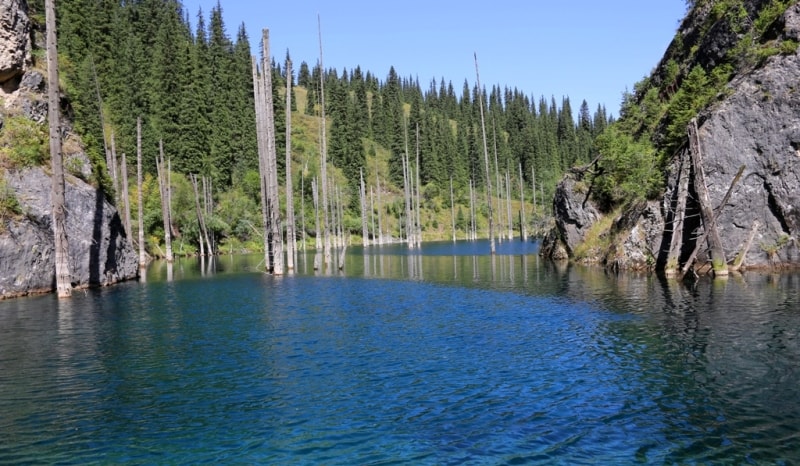
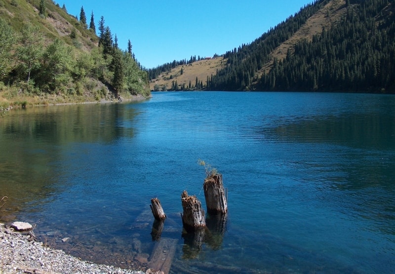
Transfer: valley-canyon Aktogay - settlement Zhalanash - lake Kaindy (57 km). Arrival in the national natural park "Kolsay Lakes" in which is the lake Kaindy, walk in vicinities. Lunch. Transfer: lake Kaindy - settlement Saty - lake Kolsai - I (26 km). Arrival in the guest house at lake Kolsai - I, accommodation. Walk in vicinities of lake. Dinner and overnight.
Day 9. Lake Kolsay - settlement Basshi (333 km).
Breakfast. Transfer: lake Kolsay - canyon Charyn (109 km, 2 hours). Arrival on canyon Charyn, walk to the river Charyn. Charyn the canyon is ensemble of palaces, towers and minarets. About such shape the gorge has reached nearby 500 000 years back. So there was «Valley of locks» - one of masterpieces of natural architecture. On slopes there are the numerous rests of mineral fauna dated bottom Carbonic period nearby 300 million years ago. Since prehistoric times of water Charyn - the largest inflow of the river Ili - laid to itself a waterway among rocks, forming in rocks a huge canyon. The termination of walk.
Transfer: canyon Charyn - settlement Chundzha - settlement Koktal - East Aktau clay mountains (148 km). Charyn passes our way from canyon on the road winding between low hills. We will go on the highway of the leader to the Chinese-Kazakh border, to the “Khorgos” check point soon. We go down to the wide valley of the river Charyn, we pass the bridge, the Charyn ashen grove is visible at the left.
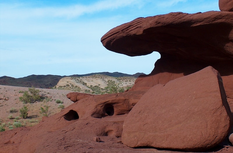
We pass the regional center of the Uigur area - settlement of Chundzha. In the settlement of Koktal we turn on the West and we begin rise to the clay mountains Syrt which are the foothills of mountains East Aktau. To the left of the road multi-colored clay mountains are located, it is a local natural sight. A short stop, walk on vicinities.
Further transfer: East Aktau clay mountains - settlement Basshi (76 km). Our further way lies on the wide intermountain valley which from the North is limited to the ridge Altyn-Emel with anonymous peak of 3297 meters above sea level. From the South the valley becomes isolated the river Ili. We pass the small pass in the mountains Atyzhek and Katu-tau. Arrival in the settlement of Basshi, transfer to hotel, accommodation, dinner and overnight.
Day 10. Settlement Basshi – Singing Barchan - Aktau mountains (Altyn-Emel national park) (249 km).
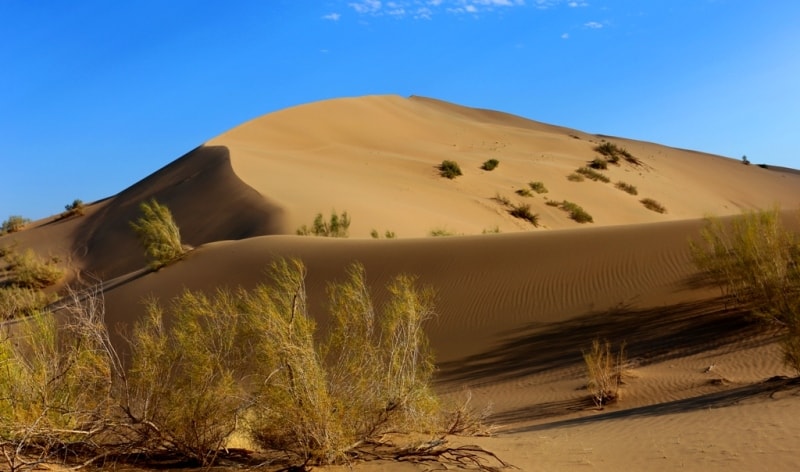
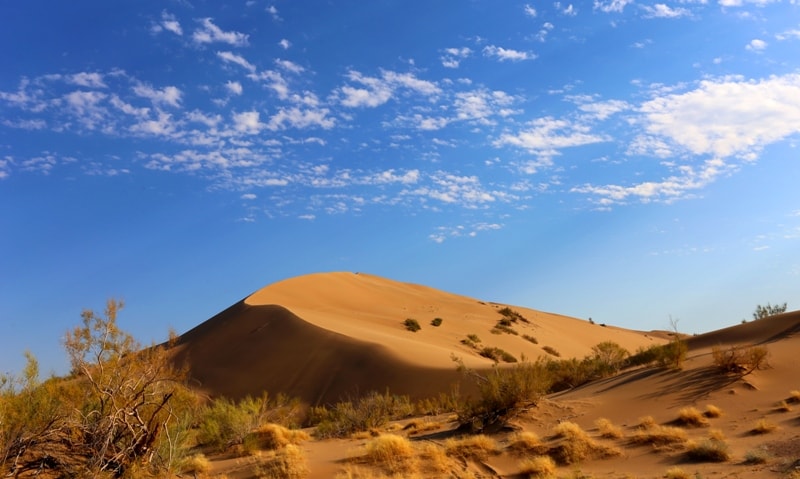
Breakfast. Transfer: settlement Basschi - cordon Shagan - cordon Mynbulak - Singing Barchan (48 km). Walk in vicinities of the Singing barchan in Altyn-Emel national nature park, at desire an ascention on sand on top of mountain from sand.
Transfer: Singing barchan - spring Valikhanov (2 km). Descent to a spring, on a legend at a spring stopped Kazakh traveller Shokan Valikhanov, walk in vicinities.
Transfer: spring Valikhanov - stones Oshaktas (8 km). Walk in vicinities stone stele Oshaktas.
Transfer: Oshaktas - cordon Mynbulak (1 km). On cordon Mynbulak it is possible to visit a small pond in which the small family of carp and other fishes live. Ancient willows, with semicentenial age, also will draw your attention, in a shadow of willows it is possible to have a rest after visiting the Singing barchan and to get drunk cold water from a spring.
The further transfer: Mynbulak - settlement Basshi (37 km). Arrival in settlement Basshi, lunch.
Transfer: Basshi - mountains Aktau (71 km). After settlement Basshi our way is passed two small settlements Nurum and Aktobe after them lays on the east between mountains Aktau and the river Ili. Gradually the country road deduces us to mountains Aktau and the further way passes along southern slopes of mountains Katu-tau and Aktau. Arrival on multi-coloured mountains Aktau, walk upwards on gorge in vicinities of mountains Aktau.
Transfer: Актау - gorge Katu-tau (26 km). Arrival on rocky file Katu-tau, walks in vicinities.
Transfer: Katu-tau - cordon-valley Kosbastau (27 km). On cordon Kosbastau there is a small artificial pond and some centenary willows, one of which more than 700 years. Walk in vicinities of valley.
Transfer: Kosbastau - settlement Basshi (29 km). Arrival in Basshi. A dinner and overnight.
Day 11. Settlement Basshi - Almaty (355 km).
Breakfast. Transfer: Basshi - pass Altyn-Emel 1711 meter above sea level - settlement Saryozek - settlement Shengeldy - river Ili - valley Tamgaly-tas (172 km). After the settlement of Basshi we pass the ridge Altyn-Emel, the big railway station Saryozek. After the station Saryozek northern spurs of the ridge Malaysary, then the small ridge Arkharly with Arkharly pass of 1086 meters above sea level are on the right side visible.
At once behind the pass before us the plateau Itzhon which from the North is limited to the mountains Malaysary comes off and in the south borders on the Kapshagay reservoir. Soon we in the valley Tamgaly-tas. "The Written Rocks on the Hi River (26 km below the Kapshagai Hydroelectric Power Station dam) contain petroglyphs, describing Buddha, which correspond to similar Budhist images from northern India.
The drawings hearken to a peaceful culture, which settled the Semirechye territory, along the northern route of the Great Silk Road, where peace was security were required for the peoples of Asia and Europe to trade. Household animals and inscriptions are also found in the ancient Tibetan and Kalmyk languages. Just a short journey from Kapchagai, on the bank of the Ili, is a place that will transport you far back in time. In the early Middle Ages there was a ford across the Ili at its narrowest point - the Kapchagai Gorge, at Tamgaly-tas.
Transfer: valley Tamgaly-tas - town Kapshagay - Almaty (114 km). After the valley Tamgaly-tas we pass on a dam of Kapshagay hydroelectric power station. Soon we in the town of Kapshagay. This city appeared from the beginning of construction of Kapchagaysky hydroelectric power station, then on the place of a reservoir there was a small settlement Ili. The Kazakhstan Las Vegas it is located on the bank of the Kapshagay reservoir, on the river Ili.
The city is known for large play space. Here casinos are located. Arrival in Almaty, transfer to hotel, accommodation. Lunch. After a lunch trip on the Big Almaty lake.
Transfer: Almaty - the Second Hydroelectric Power Station - the First Hydroelectric Power Station - lake of the Big Almaty 2511 meters above sea level) (35 km).
We pass prospectus Al-Farabi and our way lays on the south in mountains along the street which up to a dam in the Big Almaty gorge is built up by cafe and restaurants on any choosy taste. We pass a dam, construction which has begun in 1976 and has ended in 1980.
Height of a dam of 40 meters, length of 422 meters. The dam has kept catastrophic mud flow which threatened city on August, 3rd, 1977. Mud flow has left the right inflow Big Almaty - the rivers Kumbel-Su. Approximately through 1 kilometer we come to vicinities of the Second hydroelectric power station, from here one road напраляется in gorge Alma-Arasan (the Apple source), our road turns on the left in the basic gorge.
Construction of the cascade of hydroelectric power station on the river Greater Almatinka has been stipulated by plan GOELRO in 1920. With the beginning of Great Domestic war the State Committee of Defense of the USSR has made a decision on construction on the river Greater Алма-Атинка the cascade of hydroelectric power stations for maintenance with the electric power of the USSR of factories evacuated from the European part and the enterprises.
Designing and spadework have been begun by the Leningrad branch of institute " Hydroproject " in 1942, construction of the first power stations has begun with April, 1943. Construction was conducted by a method of national construction in which have taken part over 6 000 city dwellers, the military men concluded.
Concerning to prisoners at construction of hydroelectric power station: Japanese военнопленные participation in construction of Hydroelectric Power Station Hydroelectric Power Station did not accept. Japanese prisoner of war in the Big Almaty gorge, prepared a stone in vicinities of a present dam. And others constructions participated in construction of the cascade of Hydroelectric Power Station the Soviet prisoners, free settlement, in peasantry "chemists" for whom in vicinities of the First Hydroelectric Power Station the colony-settlement has been constructed of capital brick and stone houses-barracks, a dining room and kitchen, a medical unit, club and a punishment cell.
By the way the punishment cell exists and to this day, in territory of a former colony-settlement, consists of the general corridor and four chambers of the sizes 3 х, 1,5 with massive metal doors, in chambers there is a small window and the furnace. In the middle of 70-s' years of XX century a colony-settlement it has been reorientated in a rest house «Municipal employee» which have started to destroy in the beginning of 2000 years.
Works at construction of the cascade of Hydroelectric Power Station have been poorly mechanized also all labour-consuming operations carried out manually. In October, 1953 the First Hydroelectric Power Station "Ozernay" with three Italian units of firm «Ansaldo San-Jordjio» which work till now is started up in operation. The first Hydroelectric Power Station is most high-pressure water hydroelectric power station on all space of the former USSR 1900 meters above sea level.
With input of the Second Hydroelectric Power Station by capacity 14,3 МВт in July, 1959 construction of the hydrostations using energy demand the Big Almaty gorges has come to the end. In 1947 from a place of the Second Hydroelectric Power Station to the First Hydroelectric Power Station the highway on which have passed the first lorries delivered a building material and cargoes for hydroelectric power stations and hydraulic engineering constructions has been laid.
From the western slope of gorge the pipe, submitting water on the turbine of power station downwards is laid, the settlement energy mans is below located. There are many different opinions on participants of construction of the cascade of Hydroelectric Power Station. From the Big Almaty lake the metal massive pipe, diameter 2, 5 meters which is brought in the beginning to the First Hydroelectric Power Station is laid, then lasts by the top part of the western slope of gorge to the second Hydroelectric Power Station.
On a way of rise to lake the stop on one of streamers whence opens a panorama on gorge and the First Hydroelectric Power Station. We pass a hydropost to the right of the road, located in a mouth of the river Kumbel-Su on which in 1977 and 1989 have passed catastrophic have sat down. Following place of interest on our way hotel «Alpine rose» which has appeared after privatization acclimatization house "Alpine" which was at "Kazglavselezachita", city businessmen in the end of 90-s' years of the last century.
In 70-s' years the pioneer camp here worked, but after lodging per 1977 use of object as pioneer camp was inexpedient and the decision on transfer of camp "Kazglavselezashchita" was accepted. Soon we on lake Big Almaty. From vicinities of lake panoramas on peak of Sovietov of 4317 meters above sea level, peak of the Big Almaty 3608 meters above sea level, peak of Ozernyi 4216 meters above sea level open.
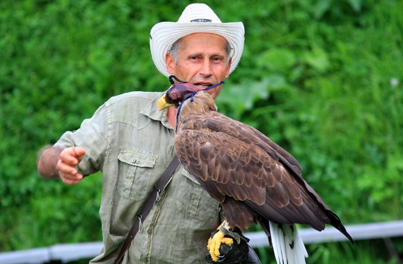
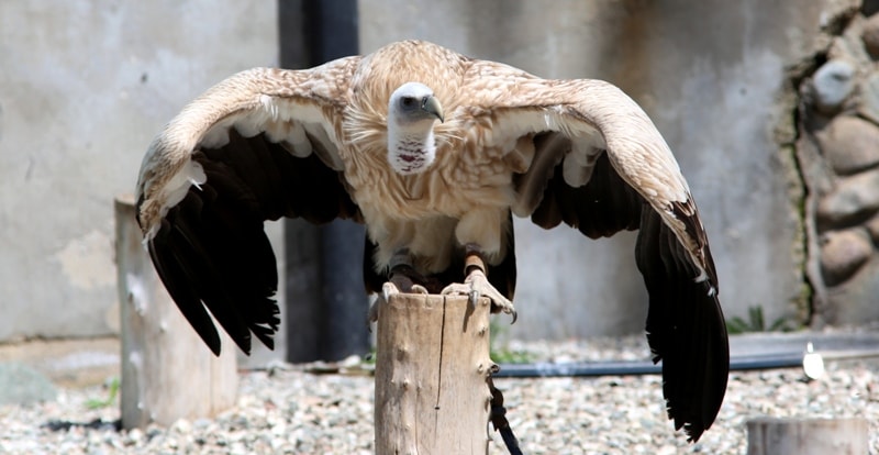
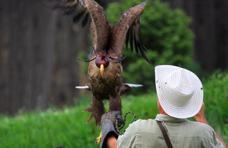
Walk in vicinities of lake. Picnic on a glade above lake. Returning in Almaty. On the way visit to Unique in Kazakhstan of show with birds of prey. Some kinds of the birds of prey showing participate in representation, under direction of man of experience hawker-berkutchi, various ways of hunting. Spectators learn about history of a falconry, biological features and a way of life of birds of prey.
After the show with birds further transfer to Almaty on the area of the Republic. Walk on vicinities and sights of the main square of the city. End of walk. Transfer to hotel. Free time. Dinner and overnight.
Day 12. Almaty.
Accompanying service at departure to airport.
Note:
Representation with birds of prey in vicinities of Almaty are to conduct daily from 17.00, except for Monday.


Note:
Author program of Alexander Petrov. Copying and introduction - from the sanction of the author .
Alexander Petrov
photos by: