You are here
Ridge Lineyskiy Belok.


Nature of Western Altai in Kazakhstan.
“In the Vth century, as now, the sun rose every morning and every evening it went to bed. In the morning, when the first rays kissed the dew, the earth came to life, the air was filled with the sounds of joy, delight and hope, and in the evening the same earth calmed down and sank into severe darkness. Day was like day, night was like night. From time to time a cloud would come up and thunder would thunder angrily, or a gaping star would fall from the sky.
A.P. Chekhov. "Untitled".
Journeys in Lineyskiy belok range.
The meridional ridge Lineysky Belok is located between the western slopes of the Koksusky ridge and between the valley of the Kuchikha river in the west, 18 kilometers northeast of the village of Poperchnoye, on the territory of the administration of the city of Ridder in the northwestern part of the East Kazakhstan region.
The Linear Squirrel Ridge is located between the Chernaya Uba and at the headwaters of the Kuchikha of the Belaya Uba basin and the Korshunovka of the Chernaya Uba basin. The Lineysky Beelok ridge stretches from north to south for 22 kilometers.
The dominant height of the ridge is Mount Vasilievsky protein with a height of 2187.6 meters above sea level, located in its central part. The southern borders of the ridge are the northern spurs of the Ivanovsky ridge. In the north, the ridge borders on the valley of the Black Uba River.
The rivers of the eastern slope of the ridge belong to the Black Uba basin: Korshunovka, Popov Klyuch, Bezymyannaya, Krutma. The rivers of the western slope of the ridge belong to the basin of the Belaya Uba: Kalmytsky stream, Gonny, Lineychikha, Svetly Klyuch, Kuchikha.
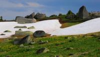
The Lineysky Belok Ridge differs from other ridges in the nature of bedrock occurrence: on helmet-shaped rocky peaks, flat slabs form lat-shaped sloping coverings. At the southern end of the ridge there is a unique geo-architectural complex of granite sculptures Liney Pillars or Stone Tale.
An amazing landmark of nature with unusual remnants that look like recognizable and fantastic animals and people. Numerous alpine ultramarine colors, with delicate shades of the lake, noisy, running down from the mountains, with rocky riverbeds.
There are vast swampy high and mid-mountain valleys that create striking contrasts and unique landscape beauty. The abundance of snowfields and precipitation contributes to the development of a rich hydrological network. The rivers flow through the mountains most of the way.
Their banks are steep, there are many rifts and rapids. Riverbeds, branching, form channels and oxbows. The run-up from the mountain peaks from a height of one and a half to two thousand meters makes the power of the water enormous: after the rains, the rivers roll large multi-pood stones along the bottom, like small plastic balls.
Geographical coordinates of Lineyskiy Belok ridge: N50°27'50.89" E84°02'56.76"
Authority and photos by
Alexander Petrov.


