You are here
Place of Anyrakai battle.

Historical places of Kazakhstan.
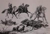
"They make their raids for the most part at night, by accident and without any order, but with an amazing desire and cry, having with them all sorts of weapons, such as: sabers, guns, arrows, sticks, stones, finally, lasso or ropes for capturing the enemy. The first blow or the first attack is always strong, and it is not easy to resist it. In it they combine all their courage."
Alexey Levshin.
Historical victories of Kazakh people.
According to the folklore sources we have reviewed, the last battle of the Kazakh-Oirot war of 1723 - 1730. occurred in the area, which is located between the Anyrakai Range and the Alakol Plain. Consequently, the historical field of the decisive clash of the Kazakhs with the enemy is only the north-eastern part of the Anyrakai tract.
The natural boundaries of the site of the Anyrakay battle should be considered in the southwest - the watershed line and the northeastern slopes of the Anyrakay mountains, in the west - the valleys of the Kopala river and the Karakemer channels. in the northeast - the Beskol tract, and in the east - the valley of the Sarybulak river.
It was this area, with an area of about 210 square kilometers, which has subtriangular outlines in plan, and became the main theater of military operations at the final stage of the nationwide resistance of the Kazakhs against the Dzungars conquerors at the end of the first third of the XVIIIth century.
As studies have shown, the geographic space of the Anyrakay battle field is characterized by a complex geomorphological structure. In the historical past, this important natural landmark of the central part of the Anyrakai Mountains made them a reliable shield or, on the contrary, a tenacious trap, or a “stone bag” for the nomadic inhabitants of the northeastern foothill zone of the Anyrakai valley during military operations, since in the first case, the mountains served as a natural barrier to the advance of enemy troops to the plain, and in the second, they were an insurmountable barrier during the forced flight of the pursued enemy in the direction of the Chui valley.
The right bank of the river is much higher than the left, so there are also only two convenient crossing points to the opposite side of the canyon. In view of the noted features of the geomorphological structure of the Anyrakay tract, the field of the Anyrakay battle has a clearly pronounced triangle shape, the base of which is the steep northeastern slopes of the Anyrakay Mountains, and the two flanks are the deep canyons of the Kopala and Sarybulak rivers.
From these three sides, the inhabitants of the "Anyrakai Triangle" were at one time reliably protected by natural boundaries from an external enemy, and only from the northeast, on the lowest and flat sections of the Kopala, Karakemer and Sarybulak valleys, did the terrain remain more or less open to the penetration of enemy armed detachments.
In that historical period, 19 or more military-defensive posts of the Dzungars were located in the most strategically important areas of this geographical space, controlling the routes of movement to the winter headquarters of the Oirat nomadic nobility and the “big urge”.
In the middle of 1728, the Dzungar Khan Galdan-Tseren (1727 - 1745) appointed his son-in-law, an experienced commander Latsang-Tserem, as the “chief commander” over the armed detachments of the Oirats stationed in them, who had more than 5,000 people at his disposal.
By the end of the first third of the XVIIIth century, the fortified area of the "Anyrakai Triangle" was the southernmost outpost of the Dzungarian military-political control in the North-Western Semirechye by the end of the first third of the XVIIIth century.
Geographical coordinates of site of Anyrakai battle: N44°04'16,92" E75°14'56,62"
Authority:
"Anyrakay Triangle Historical-Geographical Area and Chronicle of the Great Battle". I.V. Erofeeva, B.Zh. Aubekerov, A.E. Rogozhinsky, B.N. Kaldybekov, B.T. Zhanaev, L.L. Kuznetsova, R.D. Sala, S.A. Nigmatova, J.M.P. Deom. Almaty, 2008. "Dyke Press".


